Related Research Articles
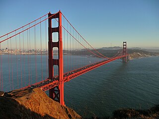
The Golden Gate Bridge is a suspension bridge spanning the Golden Gate, the one-mile-wide (1.6 km) strait connecting San Francisco Bay and the Pacific Ocean. The structure links the U.S. city of San Francisco, California—the northern tip of the San Francisco Peninsula—to Marin County, carrying both U.S. Route 101 and California State Route 1 across the strait. It also carries pedestrian and bicycle traffic, and is designated as part of U.S. Bicycle Route 95. Being declared one of the Wonders of the Modern World by the American Society of Civil Engineers, the bridge is one of the most internationally recognized symbols of San Francisco and California. It was initially designed by engineer Joseph Strauss in 1917. The bridge was named for the Golden Gate strait, the channel that it spans.

Washington Dulles International Airport, typically referred to as Dulles International Airport, Dulles Airport, Washington Dulles, or simply Dulles, is an international airport in the Eastern United States, located in Loudoun County and Fairfax County in Virginia, 26 miles (42 km) west of Downtown Washington, D.C.

Road transport or road transportation is a type of transport using roads. Transport on roads can be roughly grouped into the transportation of goods and transportation of people. In many countries licensing requirements and safety regulations ensure a separation of the two industries. Movement along roads may be by bike or automobile, truck, or by animal such as horse or oxen. Standard networks of roads were adopted by Romans, Persians, Aztec, and other early empires, and may be regarded as a feature of empires. Cargo may be transported by trucking companies, while passengers may be transported via mass transit. Commonly defined features of modern roads include defined lanes and signage. Various classes of road exist, from two-lane local roads with at-grade intersections to controlled-access highways with all cross traffic grade-separated.

A toll road, also known as a turnpike or tollway, is a public or private road for which a fee is assessed for passage. It is a form of road pricing typically implemented to help recoup the costs of road construction and maintenance.
Turnpike often refers to:

Hamilton is a city in and the county seat of Marion County, Alabama, United States. It incorporated in 1896 and since 1980 has been the county's largest city, surpassing Winfield. It was previously the largest town in 1910. At the 2020 census, the population was 7,042.

Pickerington is a city in Fairfield and Franklin counties in the central region of the U.S. state of Ohio. It was founded in 1815 as Jacksonville, named after Andrew Jackson. Pickerington was known as Jacksonville until 1827, when the citizens petitioned the state legislature to change the name to Pickerington in honor of its founder, Abraham Pickering. It is a suburb of Columbus. The population was 23,094 at the 2020 census. As land annexation, development, and immigration into the Columbus area continues, the city of Pickerington has generally followed suit. Pickerington is also home to the Motorcycle Hall of Fame, located at 13515 Yarmouth Dr. off of Interstate 70.

The River Weaver is a river, navigable in its lower reaches, running in a curving route anti-clockwise across west Cheshire, northern England. Improvements to the river to make it navigable were authorised in 1720 and the work, which included eleven locks, was completed in 1732. An unusual clause in the enabling Act of Parliament stipulated that profits should be given to the County of Cheshire for the improvement of roads and bridges, but the navigation was not initially profitable, and it was 1775 before the first payments were made. Trade continued to rise, and by 1845, over £500,000 had been given to the county.

Electronic toll collection (ETC) is a wireless system to automatically collect the usage fee or toll charged to vehicles using toll roads, HOV lanes, toll bridges, and toll tunnels. It is a faster alternative which is replacing toll booths, where vehicles must stop and the driver manually pays the toll with cash or a card. In most systems, vehicles using the system are equipped with an automated radio transponder device. When the vehicle passes a roadside toll reader device, a radio signal from the reader triggers the transponder, which transmits back an identifying number which registers the vehicle's use of the road, and an electronic payment system charges the user the toll. A major advantage is the driver does not have to stop, reducing traffic delays. Electronic tolling is cheaper than a staffed toll booth, reducing transaction costs for government or private road owners. The ease of varying the amount of the toll makes it easy to implement road congestion pricing, including for high-occupancy lanes, toll lanes that bypass congestion, and city-wide congestion charges. The payment system usually requires users to sign up in advance and load money into a declining-balance account, which is debited each time they pass a toll point.
On April 5–6, 1936, an outbreak of at least 12 tornadoes struck the Southeastern United States. Approximately 454 people were killed by these tornadoes—419 by two tornadoes alone. This outbreak is the second deadliest ever recorded in US history. Although the outbreak was centered on Tupelo, Mississippi, and Gainesville, Georgia, where the fourth and fifth deadliest tornadoes in U.S. history respectively occurred, other destructive tornadoes associated with the outbreak struck Columbia, Tennessee; Anderson, South Carolina; and Acworth, Georgia.

Gates of the Arctic National Park and Preserve is an American national park that protects portions of the Brooks Range in northern Alaska. The park is the northernmost national park in the United States, situated entirely north of the Arctic Circle. The park is the second largest in the U.S. at 8,472,506 acres, slightly larger in area than Belgium.
Becher's Brook is a fence jumped during the Grand National, a National Hunt horse race held annually at Aintree Racecourse near Liverpool, England. It is jumped twice during the race, as the 6th and 22nd fence, as well as on four other occasions during the year. It has always been a notorious and controversial obstacle, because of the size and angle of the 6 ft 9in drop on the landing side. Some jockeys have compared it to "jumping off the edge of the world."

Turnpike trusts were bodies set up by individual acts of Parliament, with powers to collect road tolls for maintaining the principal roads in Britain from the 17th but especially during the 18th and 19th centuries. At the peak, in the 1830s, over 1,000 trusts administered around 30,000 miles (48,000 km) of turnpike road in England and Wales, taking tolls at almost 8,000 toll-gates and side-bars.

Sparrows Herne Turnpike Road from London to Aylesbury was an 18th-century English toll road passing through Watford and Hemel Hempstead. The route was approximately that of the original A41 road; the Edgware Road, through Watford, Kings Langley, Apsley, the Boxmoor area of Hemel Hempstead, Berkhamsted, Northchurch, Cow Roast and Tring. Much of this part is now numbered the A4251 road. It linked in with other turnpikes to the north forming a route to Birmingham.
The Port Kent and Hopkinton Turnpike was a 19th-century toll road in the North Country of New York in the United States. It began in the town of Hopkinton and ended at the hamlet of Port Kent, located on the western shore of Lake Champlain. The turnpike was constructed in the early 1830s and was completed in 1833. The tolls along the road were removed just five years later; however, parts of the former turnpike later became the basis for several 20th century state highways. One, the former New York State Route 99 (NY 99), is still known today as the "Port Kent–Hopkinton Turnpike".
Tollgate is an unincorporated community in Umatilla County, Oregon, United States. It lies between Weston and Elgin on Oregon Route 204.

A high-occupancy toll lane is a type of traffic lane or roadway that is available to high-occupancy vehicles and other exempt vehicles without charge; other vehicles are required to pay a variable fee that is adjusted in response to demand. Unlike toll roads, drivers have an option to use general purpose lanes, on which a fee is not charged. Express toll lanes, which are less common, operate along similar lines, but do not exempt high-occupancy vehicles.

Dolph is an unincorporated community in Tillamook County, Oregon, United States, near the Yamhill County line. It lies at the junction of Oregon Route 22 and Oregon Route 130 between Grande Ronde and Hebo, on the Little Nestucca River. It is within the Siuslaw National Forest in the Northern Oregon Coast Range.
Toll Gate is an unincorporated community in Ritchie County, West Virginia, United States. Toll Gate is 3 miles (4.8 km) east-southeast of Pennsboro.