Vestnes is a municipality in Møre og Romsdal county, Norway. Vestnes is part of the traditional district of Romsdal. The administrative centre of the municipality is the village of Vestnes. Other villages in the municipality include Vikebukt, Vik, Øverås, Fiksdal, Tomrefjord, and Tresfjord.

Selbu is a municipality in Trøndelag county, Norway. The administrative centre of the municipality is the village of Mebonden. Other villages in Selbu include Flora, Fossan, Hyttbakken, Innbygda, Selbustrand, Trøa, Tømra, and Vikvarvet.

Sandane is the administrative centre of the municipality of Gloppen in Sogn og Fjordane county, Norway. It is located at the end of the Gloppefjorden, along the European route E39 highway. Sandane is 20 kilometres (12 mi) south of the village of Nordfjordeid and about 16 kilometres (9.9 mi) west of the village of Byrkjelo. Sandane Airport, Anda is located 10 kilometres (6.2 mi) northwest of Sandane along highway E39. Sandane has several suburban areas that surround the nearby fjord such as Sørstranda to the west and Vereide to the northwest.

Eidsvåg is a village in Nesset Municipality in Møre og Romsdal county, Norway. It is the administrative centre of the municipality. Eidsvåg is located at the end of the Langfjorden on the isthmus connecting the Romsdal peninsula to the Norwegian mainland. It is located about 8.5 kilometres (5.3 mi) southwest of the village of Raudsand, about 20 kilometres (12 mi) north of the village of Eresfjord, and 9 kilometres (5.6 mi) north of the village of Boggestranda. Nesset Church is located in this village.

Fiskåbygd or Fiskå is a coastal village that is also the administrative centre of Vanylven Municipality in Møre og Romsdal county, Norway. The village is located about 100 kilometres (62 mi) southwest of the city of Ålesund, about 12 kilometres (7.5 mi) east of the village of Myklebost, and about 30 kilometres (19 mi) southwest of the village of Rovdane. Fiskåbygd lies along the shores of the Vanylvsfjorden, east of the Stadlandet peninsula in Selje Municipality.

Sogndalsfjøra is the administrative center of the municipality of Sogndal in Sogn og Fjordane county, Norway. It is located where the river Sogndalselvi runs out in the Sogndalsfjorden, a branch of the large Sognefjorden. The village is located about 3.5 kilometres (2.2 mi) northwest of the village of Kjørnes, about 10 kilometres (6.2 mi) northwest of the village of Kaupanger, and about 31 kilometres (19 mi) southeast of the village of Fjærland.
Skei is the administrative centre of the municipality of Jølster in Sogn og Fjordane county, Norway. The village is located at the northeastern end of the lake Jølstravatnet. Skei is 20 kilometres (12 mi) south of the village of Byrkjelo, 25 kilometres (16 mi) northeast of the villages of Vassenden/Langhaugane, and about 13 kilometres (8.1 mi) east of the village of Ålhus. Skei is located just west of Jostedalsbreen National Park. The village lies at the intersection of two major regional highways: European route E39 and Norwegian National Road 5.

Dale or Dale i Sunnfjord is the administrative centre of the municipality of Fjaler in Sogn og Fjordane county, Norway. The village is located at the mouth of the river Vassdalselva on the southern shore of the Dalsfjorden in the northern part of Fjaler, about 6.5 kilometres (4.0 mi) northeast of the village of Flekke and about 20 kilometres (12 mi) west of the village of Bygstad.

Selbusjø or Selbusjøen is the 17th largest lake in Norway. It is located in Trøndelag county, primarily in the municipality of Selbu, although the western end of it lies in Klæbu. The 58.26-square-kilometre (22.49 sq mi) lake is the largest lake in the southern part of Trøndelag county. Selbusjø is part of the Nea-Nidelv watershed, with the Nea River flowing into it on the eastern end and the Nidelva River flowing out the western end. The deepest part of the lake reaches 206 metres (676 ft) below the surface. The villages of Selbustrand, Fossan, Tømra, Trøa, Innbygda, Mebonden, Vikvarvet, and Sjøbygda lie around the lake.

Vikedal or Vikadal is a village in Vindafjord municipality in Rogaland county, Norway. The village is located along the krosfjorden, about 7 kilometres (4.3 mi) south of the village of Sandeid and about 8 kilometres (5.0 mi) northwest of the village of Imslandsjøen. Vikedal Church is located in this village.

Bru or Ploganes is a village in the municipality of Kvam in Hordaland county, Norway. It's located in the Strandebarm area, on the northern shore of the Hardangerfjorden. It is located about 6 kilometres (3.7 mi) north of the village of Omastranda and about 10 kilometres (6.2 mi) northwest from the village of Kysnesstranda in Jondal Municipality.

Fiksdal or Fiksdalen is a village in Vestnes Municipality in Møre og Romsdal county, Norway. The village is located on the west side of the Tomrefjorden, about 8 kilometres (5.0 mi) northwest of the village of Tomra. The 0.31-square-kilometre (77-acre) village has a population (2013) of 258, giving the village a population density of 832 inhabitants per square kilometre (2,150/sq mi). Fiksdal Church is located in this village. Fiksdal is also the hometown of Norwegian international footballer Kjetil Rekdal.

Trøa is a village in the municipality of Selbu in Trøndelag county, Norway. It is located along the eastern end of the lake Selbusjøen, just north of the village of Innbygda, about 5 kilometres (3.1 mi) north of the municipal center of Mebonden, and about 4 kilometres (2.5 mi) south of the village of Tømra.
Tomrefjorden is a fjord in Vestnes Municipality in Møre og Romsdal county, Norway. The 9-kilometre (5.6 mi) long fjord branches off of the main Romsdalsfjorden and it is one of the two big fjords that cut into the municipality. The fjord is located about 8 kilometres (5.0 mi) west of the village of Vestnes. The Norwegian County Road 661 follows the shoreline around most of the fjord and it passes through the villages of Fiksdal, Tomra, and Vik.
Fossan is a village in the municipality of Selbu in Trøndelag county, Norway. It is located about 5 kilometres (3.1 mi) north of the municipal center of Mebonden, across the lake Selbusjøen. Fossan is located about halfway between the villages of Selbustrand and Tømra.

Hermansverk or Leikanger is a large village in the municipality of Leikanger in Sogn og Fjordane county, Norway. The village serves as the administrative centre of both the municipality of Leikanger and also Sogn og Fjordane county.
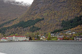
Vestnes is the administrative centre of Vestnes Municipality in Møre og Romsdal county, Norway. The village is located on the western shore of the Tresfjorden, near where the fjord empties into the main Romsdal Fjord. The village lies along the European route E39 highway. The 1.87-square-kilometre (460-acre) village has a population (2013) of 2,241 which gives the village a population density of 1,198 inhabitants per square kilometre (3,100/sq mi), and making it the largest settlement in the whole municipality.

Tingvollvågen or Tingvoll is the administrative centre of Tingvoll Municipality in Møre og Romsdal county, Norway. The village is located on a small inlet off the Tingvollfjorden, directly across the fjord from the village of Angvika. Tingvollvågen lies about 10 kilometres (6.2 mi) north of Meisingset and about 20 kilometres (12 mi) south of Straumsnes. The historic Tingvoll Church is located in this village. Norwegian National Road 70 runs through the village on its way from Kristiansund to Oppdal.

Jondal is the administrative centre of Jondal municipality in Hordaland county, Norway. The village is located on the southern shore of the Hardangerfjorden, about 55 kilometres (34 mi) southeast of the city of Bergen. It is located on the Folgefonna peninsula, about 12 kilometres (7.5 mi) northwest of the Folgefonna glacier in Folgefonna National Park. The village of Kysnesstranda lies about 15 kilometres (9.3 mi) to the south. The 0.59-square-kilometre (150-acre) village has a population (2013) of 379, giving the village a population density of 642 inhabitants per square kilometre (1,660/sq mi).