Torbane, New South Wales

Last updated

Torbane was a privately-owned village lying within the area now known as Capertee, [1] in the Local Government Area of the City of Lithgow, within the Central West region of New South Wales, Australia. There was also another village, Airly, nearby. Both villages were associated with the mining of oil shale. The mine associated with Torbane was known as the New Hartley Mine. and that associated with Airly was known as the Genowlan Mine. There were retorts that produced crude shale oil at Torbane. Both Torbane and Airly are now ghost towns.

Contents

History

Aboriginal presence

The area lies within the traditional lands of Wiradjuri people. [2] There are Aboriginal heritage sites in the area. [3]

Mining, oil production, and mining villages

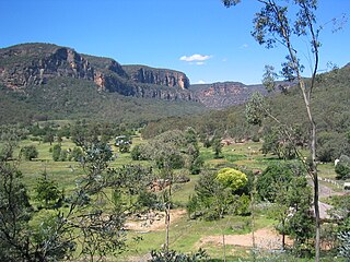
Torbane takes its name from Torbane Hill in Bathgate, Scotland, and shares a similar etymology with Torbanite, a type of oil shale that is found there. It was the mining of oil shale that first led to the establishment of the villages of Tobane and Airly. The area is dominated by two mountains, actually mesas, Mount Airly and Genowlan Mountain, that rise from the broad floor of the Capertee Valley. Between the two is the Airly Gap. [4] [5] The mining was mainly on the eastern side of Airly Mountain, the western side of Airly Gap. The village of Torbane was on the western side of Airly Mountain, whereas the village of Airly was to its east. Airly and Mount Airly are supposed to have been named after Airlie Castle in Scotland. [5]

Prospectors found workable deposits of oil shale and took out leases on the eastern side of Mount Airly, but apparently lacked finance and the leases were cancelled.The first mining of oil shale began in 1883, when a German syndicate, The Genowlan Shale Company, took up the leases and began to send the highest grade shale to Germany, for enrichment of town gas. The village of Airly developed as a result. [5] The shale was hauled in drays to the railway at Capertee. Later a horse-drawn tramway and a rope-haulage rail track, over the southern end of Mount Airly, toward the railway line, was used. [5]

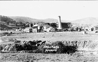
A second mine developed to the north, with a separate rope-haulage line over the northern end of Mount Airly to a site near where the village of Torbane developed. This second mine was originally known as 'King's Mine'; it became known as the 'New Hartley Mine' when it was purchased by the New South Wales Shale and Oil Company, operator of the shale oil mines at Hartley Vale, in 1896. Forty vertical retorts and other structures were erected in 1900. Crude oil produced in the retorts was sold to the Australian Gas Light Co, for gas enrichment, but was also railed to the company's existing shale oil refinery at Hartley Vale, for further processing by fractional distillation. The retorts required coal as fuel, and this was obtained from the Wongawilli coal seam, which also outcropped at Mount Airly. Later, a tunnel, cut into the coal seam and passing right through the mountain, was used to accommodate the rope-haulage tramway, replacing the steep route over the mountain. [5] [6] [7]

In the meantime, by 1903, the Glenowlan mine had been leased to the Australian Shale Syndicate and was being mined by the Australian Kerosene Oil and Mineral Company, operator of the old Joadja works, for the payment a royalty fee on each ton mined. The two mines—New Hartley and Genowlan—were mining the same seam of oil shale, and a dispute arose, [8] which was won by New South Wales Shale and Oil Company. [9] By mid 1904, A.K.O. & M. operations at the Genowlan mine had ceased. [10] Shareholders of Australian Kerosene Oil and Mineral Co. voted to voluntarily wind up that company in 1906. [11] The leases held by the Australian Shale Syndicate were sold to the British Australian Oil Company in 1910, and that company operated a mine at Airly, for some years thereafter, to supply the Torbane retorts. [12]

Newly-completed Pumpherson retorts, with a train of oil tanker wagons in the foreground, Torbane, 1908. Torbane, N.S.W. - Newly completed oil shale retorts (Lithgow Mercury, 5 June 1908, p.3).jpg
Newly-completed Pumpherson retorts, with a train of oil tanker wagons in the foreground, Torbane, 1908.

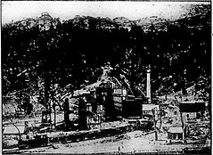
In April 1906, the assets of the New South Wales Shale and Oil Company were bought by the Commonwealth Oil Corporation. In 1908, it erected 32 new vertical retorts at Torbane, built to a Scottish design, [14] [13] [15] the Pumpherson retort, while continuing to operate the 40 existing retorts. [15]

There was a siding and railway station, on the Gwarbegar line, named Torbane, from which crude oil for refining and oil shale were dispatched. The siding opened in 1897, followed by the station (a platform and waiting shed), in 1900, which was enlarged in 1912. It closed in 1974. The station was located a little to the south of where the turn out for the rail loading loop of the Airly Mine is now. [16] [17] [18] [19] [20] From the siding, a steam-hauled standard-gauge private railway ran about three kilometres to the retorts site at Torbane. [5] Two locomotives were used on the branch line, ex-NSWGR 69x and 360x. [21]

There was a post office at Torbane, known as Torbane Mines, between 1902 and 1920. [22] and a school, known as Torbane, between 1899 and 1920. [23] At the neighbouring village of Airly, from 1897, there was a school, known as Genowlan, until 1910, and then known as Airly, until it closed in 1920. [24] Airly had a post office of that name, from 1897 to 1920. [25]

From January 1903, Airly had a church hall constructed of stone; it was intended to be reusable as the basement of a larger church building in the event that it would be needed in future. [26] Whether or not the church hall was operated as a Union Church, it may have been used by at least three denominations. Services at Airly were conducted by a Catholic priest based at Sofala, an Anglican minister based at Running Stream, [27] and probably by a Methodist minister based in Ryalstone. [28]

In May 1896, a cave on Glenowlan Mountain was where a Spanish man, who spoke no English, John Terossa, better known as the notorious outlaw 'Slippery Jack', was captured by police. He had lived in the bush, for around two years, and survived by burgling and stealing food from farms. He was sentenced to five years for burglary. [29] [30] [31]

Both Mount Airly and Genowlan Mountain are capped in basalt in places, and under these caps are deep lead deposits that contained gold and diamonds, which have been mined on a small scale. [5]

Decline and closure

In 1913, by then operated by Commonwealth Oil Corporation Ltd, the oil shale works at Torbane was closed down, [32] probably due to the difficulties the company found itself facing at their newer and far larger site at Newnes. The closure reduced Torbane's population to around 35, mostly families of men seeking work elsewhere. Some mining continued at Airley, taking shale for use by the railways in gas-making. [33]

The Torbane retorts were reopened in 1916, before finally closing in 1918, [34] during the time that COC was under the management of John Fell. Mining had ceased in June 1918. [35] It is likely that this later period of operation was facilitated by government subsidies paid for local oil production in wartime. In 1920, most of the buildings in the Torbane township were pulled down and relocated to Newnes. [36]

Another company, Torquay and Anglesea Oil Co. erected retorts and other structures there in 1925-1926, [37] [38] but the proposed operation seems not to have started production. Around the same time, Commonwealth Oil Corporation removed firebricks from its old retorts, for use at the new oil refinery, at Clyde in Sydney, that was being built by John Fell. [39] The dismantling work, including lifting of the private railway line was completed by 1930, [40] the same year in which the Commonwealth Oil Company was deregistered. [41]

During the Second World War, Genders, the owners of the Great Cobar Colliery at Lithgow, erected new shale retorts at Torbane to produce petrol for their own vehicle fleet. [42]

Remnants

The area, where the mines, retorts and villages were, is east of the Castlereagh Highway and north of Glen Davis Road. Part of the area is part of the Mugii Murum-ban State Conservation Area. Little remains of the village of Torbane, which now lies on private land. The old manager's house at Torbane survives as a private residence. There are ruins of retorts, industrial buildings and storage tanks at the old retorts site at Torbane, which also lie on private land.

There are ruins at Airly, including of some miners' huts that made use of natural cavities in the rock face and the village's German-style bakery. [43] [44] [45] [40] Part of the site and the area extending west to the railway line is occupied by the Airly Mine, where thermal coal is mined by Centennial Coal. [46] The road running from Glen Davis Road across the Airly Mine's land is still known as Torbane Road. [47]

See also

Reference section

  1. "Capertee · New South Wales 2846, Australia". Google Maps. Retrieved 9 October 2021.
  2. Studies, Australian Institute of Aboriginal and Torres Strait Islander (10 January 2021). "Map of Indigenous Australia". aiatsis.gov.au. Retrieved 16 October 2021.
  3. "CENTENNIAL COAL - AIRLY MINE ANNUAL REVIEW" (PDF). Centennial Coal. March 2017. pp. 25, 26.
  4. "Mount Airly · Capertee NSW 2846, Australia - Terrain view". Google Maps. Retrieved 13 March 2022.
  5. 1 2 3 4 5 6 7 Brown, Jim W. Bent Backs - An illustrated social and technological history of the Western Coal Field. Lithgow: Industrial printing Company. pp. 146, 147, 148, 151, 153–162.
  6. "MINING". Evening News. 18 June 1896. p. 3. Retrieved 19 July 2022.
  7. "THE NEW OIL CONTRACT". Lithgow Mercury. 30 January 1900. p. 2. Retrieved 13 March 2022.
  8. "ALLEGED TRESPASS ON A SHALE MINE". Lithgow Mercury. 4 September 1903. p. 5. Retrieved 19 July 2022.
  9. "VERDICT FOR £2000". Evening News. 9 September 1903. p. 5. Retrieved 19 July 2022.
  10. "THE MINES REPORT FOR 1903". Lithgow Mercury. 27 May 1904. p. 5. Retrieved 19 July 2022.
  11. "THE AUSTRALIAN KEROSENE OIL AND MINERAL COMPANY (LIMITED)". Government Gazette of the State of New South Wales. 5 September 1906. p. 5044. Retrieved 19 July 2022.
  12. "Two Townships Wiped Out". Cobar Herald. 27 June 1913. p. 3. Retrieved 20 July 2022.
  13. 1 2 "THE TORBANE RETORTS". Lithgow Mercury. 5 June 1908. p. 3. Retrieved 13 March 2022.
  14. "COMMONWEALTH OIL CORPORATION". Sydney Morning Herald. 18 December 1906. p. 9. Retrieved 26 April 2022.
  15. 1 2 "NEW RETORTS AT TORBANE". Daily Telegraph (Sydney) . 28 May 1908. p. 4. Retrieved 6 November 2022.
  16. "Torbane Station". nswrail.net. Retrieved 9 October 2021.
  17. "Torbane". Mudgee Guardian and North-Western Representative. 27 April 1900. p. 7. Retrieved 13 March 2022.
  18. "NO. 1 GANG". Mudgee Guardian and North-Western Representative. 5 September 1912. p. 23. Retrieved 13 March 2022.
  19. "33°06'44.6"S 149°59'15.7"E · Capertee NSW 2846, Australia". Google Maps. Retrieved 16 October 2021.
  20. "Mines and Miners". Worker. 5 December 1903. p. 2. Retrieved 13 March 2022.
  21. "The Shale Railways of New South Wales - book review". lrrsa.org.au. Retrieved 22 July 2022.
  22. "View Post Office Details - Torbane Mines". www.phoenixauctions.com.au. Retrieved 6 March 2022.
  23. "Torbane". nswgovschoolhistory.cese.nsw.gov.au. Retrieved 6 March 2022.
  24. "Airly". nswgovschoolhistory.cese.nsw.gov.au. Retrieved 6 March 2022.
  25. "View Post Office Details - Airly". www.phoenixauctions.com.au. Retrieved 6 March 2022.
  26. "CHURCH HALL FOR AIRLY". Lithgow Mercury. 20 January 1903. p. 3. Retrieved 29 January 2023.
  27. "AIRLY". Lithgow Mercury. 12 May 1909. p. 1. Retrieved 29 January 2023.
  28. "AIRLY". Lithgow Mercury. 28 April 1909. p. 3. Retrieved 29 January 2023.
  29. "COUNTRY NEWS. (FROM OUR CORRESPONDENTS.) CAPTURE OF " SLIPPERY JACK."". Sydney Morning Herald. 23 May 1896. p. 9. Retrieved 13 March 2022.
  30. ""SLIPPERY JACK."". Evening News. 28 July 1896. p. 6. Retrieved 13 March 2022.
  31. "Notes of the Week". Sydney Mail and New South Wales Advertiser. 1 August 1896. p. 224. Retrieved 13 March 2022.
  32. "TORBANE OIL WORKS". Daily Telegraph. 20 June 1913. Retrieved 9 October 2021.
  33. "AIRLY AND TORBANE". Lithgow Mercury. 13 February 1914. p. 4. Retrieved 20 July 2022.
  34. "Photograph of 'Shale retorts and condensers, Commonwealth Oil Corporation, Torbane, near Capertee, New South Wales'". collection.maas.museum. Retrieved 13 March 2022.
  35. "Airly Shale Mine Closed". Mudgee Guardian and North-Western Representative. 17 June 1918. p. 2. Retrieved 20 July 2022.
  36. "CAPERTEE". Lithgow Mercury. 9 April 1920. p. 3. Retrieved 20 July 2022.
  37. "OIL ACTIVITIES". Mudgee Guardian and North-Western Representative. 22 April 1926. Retrieved 9 October 2021.
  38. "TORQUAY AND ANGLESEA OIL CO". Age. 3 March 1926. p. 18. Retrieved 13 March 2022.
  39. "COMMONWEALTH OIL CO". Mudgee Guardian and North-Western Representative. 16 November 1925. Retrieved 9 October 2021.
  40. 1 2 "National Trust Register, Industrial Heritage Listing Report - Airly Shale Mine and Torbane Refinery Remains".
  41. Register of Defunct Companies. Springer. 1 March 1990. p. 130. ISBN   978-1-349-11271-5.
  42. Pells, Philip J.; Hammon, Philip J. (2009). The burning mists of time: a technological and social history of mining in Katoomba. Blackheath: Writelight. p. 125. ISBN   978-0-9775639-6-8.
  43. "Satellite View 33°06'07.2"S 150°00'59.0"E · Capertee NSW 2846, Australia". Google Maps. Retrieved 29 March 2022.
  44. "Airly Gap campground". NSW National Parks. Retrieved 14 March 2022.
  45. "Torbane Oil Works". dingogap.net.au. Retrieved 13 March 2022.
  46. "Mining Operations & Energy Solutions In Airly: Centennial". Centennial Coal. Retrieved 16 October 2021.
  47. "Satellite view -Torbane Rd · Capertee NSW 2846, Australia". Google maps. Retrieved 25 September 2022.

33°06′07.2″S150°00′59″E / 33.102000°S 150.01639°E / -33.102000; 150.01639

Related Research Articles

<span class="mw-page-title-main">Newnes, New South Wales</span> Town in New South Wales, Australia

Newnes, an abandoned oil shale mining site of the Wolgan Valley, is located in the Central Tablelands region of New South Wales, Australia. The site that was operational in the early 20th century is now partly surrounded by Wollemi National Park. The settlement was originally built by the Commonwealth Oil Corporation.

<span class="mw-page-title-main">Glen Davis, New South Wales</span> Town in New South Wales, Australia

Glen Davis is a village in the Central Tablelands of New South Wales, Australia. The village is located in the local government area of the City of Lithgow. It is located 250 km north-west of Sydney and approximately 80 kilometres north of Lithgow. The name is also applied to the surrounding area, for postal and statistical purposes. In the 2006 census, Glen Davis had a population of 354 but this fell to 115 in the 2016 census.

Kandos is a small town in the Central Tablelands of New South Wales, Australia, within the Mid-Western Regional Council. The area is the traditional home of the Dabee tribe of the Wiradjuri people. The town sits beneath Cumber Melon Mountain, in a district formerly known as Coomber. Kandos shares its locality, employment and infrastructure with the neighbouring town Rylstone, 6 kilometres away. At the 2021 census, Kandos had a population of 1263.

<span class="mw-page-title-main">Gwabegar railway line</span>

The Gwabegar railway line is a railway line in the Central West and North West Slopes of New South Wales, Australia, which passes through the towns of Mudgee, Gulgong, Dunedoo, Coonabarabran and terminates at Gwabegar.

<span class="mw-page-title-main">Hartley Vale, New South Wales</span> Town in New South Wales, Australia

Hartley Vale is a small village in the Blue Mountains area of New South Wales, Australia. It is approximately 150 kilometres west of Sydney and 12 kilometres south-east of Lithgow. It is in the local government area of the City of Lithgow.

<span class="mw-page-title-main">Capertee Valley</span>

The Capertee Valley is a large canyon in New South Wales, Australia, 135 km (84 mi) north-west of Sydney that is noted to be the second widest of any canyon in the world, exceeding The Grand Canyon. It is located 135 km (84 mi) kilometres north-west of Sydney, between Lithgow and Mudgee, in the Central Tablelands, just above the Blue Mountains.

<span class="mw-page-title-main">Wollar</span> Town in New South Wales, Australia

Wollar is a village in New South Wales, Australia. The town is located 316 kilometres (196 mi) north west of the state capital Sydney and 48 kilometres (30 mi) north-east of the regional centre of Mudgee, near the Goulburn River National Park. At the 2006 census, Wollar and the surrounding region had a population of 304. By the 2016 census the village of Wollar and district was reduced to 69 persons living in 50 private dwellings.

<span class="mw-page-title-main">William Wall (Australian politician)</span> Australian politician (1845–1926)

William Chandos Wall was an Australian politician. He was also a prospector, geologist, minerals surveyor, commission / mining agent, inventor and a quarry and mine operator before and after entering politics. In June 1886 he was elected to the New South Wales Legislative Assembly to succeed the former NSW premier Sir John Robertson KCMG as one of the members for Mudgee. In 1894 Wall transferred to Rylstone and in July 1895 he lost the Rylstone seat.

Kerosene Vale is a historic locality within the City of Lithgow Local Government Area of New South Wales, Australia. Kerosene Vale lies near Lidsdale and Wallerawang. It is considered part of Lidsdale for census purposes. It should not be confused with Hartley Vale, another locality with a history of shale oil production, which is also within the City of Lithgow. The name Kerosene Vale is now only used infrequently.

There are oil shale deposits in Australia which range from small deposits to large reserves. Deposits, varying by their age and origin, are located in about a third of eastern Australia. In 2012, the demonstrated oil shale reserves were estimated at 58 billion tonnes. The easiest to recover deposits are located in Queensland.

<span class="mw-page-title-main">Glen Davis Shale Oil Works</span> Oil extraction plant

The Glen Davis Shale Oil Works was a shale oil extraction plant, in the Capertee Valley, at Glen Davis, New South Wales, Australia, which operated from 1940 until 1952. It was the last oil-shale operation in Australia, until the Stuart Oil Shale Project in the late 1990s. For the period of 1965–1952, it provided one fifth of the shale oil produced in Australia.

Commonwealth Oil Corporation Limited was a British-owned Australian company associated with the production and refining of petroleum products derived from oil shale, during the early years of the 20th century. It is associated with Newnes, Hartley Vale, and Torbane, all in New South Wales. It should not be confused with Commonwealth Oil Refineries, which was a completely separate company, established in 1920, that refined imported crude oil from 1924.

Clandulla is a village in New South Wales, Australia, within the Mid-Western Regional Council, about 225 kilometres north-west of Sydney. At the 2016 census Clandulla and the surrounding rural district had a population of 197, living in 61 private dwellings. The township and district also included 22 unoccupied private dwellings. Clandulla is bounded to the west and north by the Clandulla State Forest.

<span class="mw-page-title-main">John Fell (industrialist)</span>

John Wilson Fell (1862–1955) was an industrialist involved in the shale oil operations at Newnes, New South Wales and the establishment of two early oil refineries, on Gore Bay at Greenwich and at Clyde, both suburbs of Sydney. He was the principal of John Fell & Company and was, for many years, the Managing Director of Commonwealth Oil Corporation, which he revived from receivership.

<span class="mw-page-title-main">British Australian Oil Company</span> Former shale oil company of Australia

The British Australian Oil Company Limited was a British-owned company—incorporated in 1910—that mined oil shale and produced shale oil and refined oil products, in New South Wales, Australia, during the years from 1911 to 1915.

The New South Wales Shale and Oil Company — established in 1872, by the merging of two earlier ventures — mined and processed oil shale to produce kerosene, paraffin wax and candles, and other petroleum products, in New South Wales Australia. It is particularly associated with the sites of its former works, at Hartley Vale and Torbane. Its assets were bought by Commonwealth Oil Corporation in 1906.

<span class="mw-page-title-main">Mugii Murum-ban State Conservation Area</span> Protected area in New South Wales, Australia

Mugii Murum-ban State Conservation Area is north of Lithgow, north-east of Capertee and south-east of Mudgee.

Australian Kerosene Oil Company or 'A.K.O' mined and processed oil shale to produce kerosene, paraffin wax and candles, lubricating oil and greases, and other petroleum-based products, in New South Wales Australia. It is particularly associated with the site of its mine and works, at Joadja. At times, it also had other mining operations, at Airly and near Katoomba, and a soap and candle factory at Camellia. The company used the brand name 'Southern Cross' for its kerosene products.

Lidsdale is a locality within the City of Lithgow Local Government Area of New South Wales, Australia. It lies to the north of Wallerawang. Its area, as defined for postal and statistical purposes, includes the historic locality of Kerosene Vale and the small rural areas known as Springvale and Angus Place. In 2021, its population was 471.