Torfinnstindene is a mountain with three summits in Norway, the highest at 2120 m above sea level. It is located within the municipality of Vang, Innlandet, in the southernmost part of the Jotunheimen mountain area. It is situated on the northern shore of lake Bygdin on the western side of the Svartdalen Valley and is the southernmost and most prominent summit on a rather long ridge containing twelve more 2000 m peaks. The summit can be observed from most of the mountain areas south of Jotunheimen.
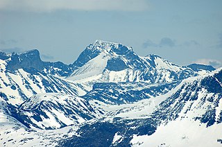
The three Torfinnstindene summits seen from Kalvehøgde.
The mountain consists of three summits, named Østre, Midtre and Vestre Torfinnstind (Eastern, Middle and Western). The name probably derives from the Norwegian male name Torfinn, but some sources claim that the name derives from the local name of a type of grass and has during the last 100 years been transformed into Torfinn, which is close to the name of the grass, Turfing. The name is also found in the valley due west of the summits, the small glacier covering parts of the extremely steep north wall, the sharp ridge pointing northwards from the Western summit and the tourist lodge situated on lake Bygdin south of the mountain.
The summits are the southernmost 2000 m peaks in Norway, but one, and is made of the extremely hard gabbro rock. The gabbro in Torfinnstindene is partly of the normal "gray-with-black-specs" variety, but parts of the eastern summit are of a red variety. The view from the summits, particularly the Eastern, is one of the best in southern Norway. On a clear day, you can see almost as far as Oslo.
The Eastern and Western summits can be reached after a rather strenuous hike, but the Middle summit can only be climbed - normally as part of a traverse of all the summits. The following is a brief description of the trip. The first part of the hike follows the grass- and flower-covered slope on the southeast flank of the Eastern summit. A number of ravines, dug out by meltwater from the Ice Age on, leads towards the summit. Only one of them leads all the way to the eastern shoulder of the summit. This is a steep climb, but with good weather conditions no equipment is needed.
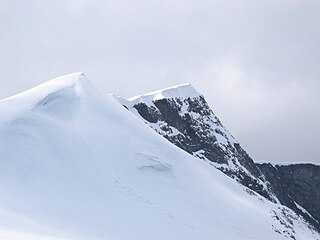
The vertical western wall of Eastern Torfinnstind towards the steep wall of Middle Torfinnstind.
From the eastern summit, a long rappel is needed to reach the very steep and narrow pass between the two summits. The climb to the middle summit needs no equipment. From the middle summit three rappels are needed to get all the way down to the even more steep and narrow pass between the two last summits. The climb up the lowest, western summit, is quite easy, but many would prefer to use a rope on a short part of the climb. From the western summit, a sharp edge leads down to the long ridge turning northwards towards lake Gjende. The rest of the descent is long talus slopes.
The climb of the eastern summit has gained popularity in the last years of increased peak bagging in Norway, and guided tours are arranged. The traverse is also popular, but the number who completes it is much lower than the number of visitors on the eastern summit. The western, easiest and lowest summit is visited rather rarely except by those traversing.
Related Research Articles
Galdhøpiggen is the highest mountain in Norway, Scandinavia and Northern Europe, at 2,469 m (8,100 ft) above sea level. It is in the municipality of Lom in Innlandet county and in the Jotunheimen mountain area.
Sgùrr Dearg is a mountain in the Cuillin on the Isle of Skye, Scotland. It is topped by the Inaccessible Pinnacle, a fin of rock measuring 50 metres (150 feet) along its longest edge. The top of the Inaccessible Pinnacle, which at 985.8 m (3,234 ft) is the highest point of Sgùrr Dearg and the only Munro with a peak that can only be reached by rock climbing. This makes it the biggest hurdle for many Munro baggers.
The Watzmann is a mountain in the Bavarian Alps south of the village of Berchtesgaden. It is the third highest in Germany, and the highest located entirely on German territory.
The Aiguille de Bionnassay is a mountain in the Mont Blanc massif of the Alps in France and Italy. It has been described as "one of the most attractive satellite peaks of Mont Blanc", and is located on its western side. The mountain's south and east ridges form the frontier between the two countries, and its summit is a knife-edge crest of snow and ice. Reaching it via any route provides a "splendid and serious snow and ice climb".
Glittertind is the second highest mountain in Norway, at 2,465 m above sea level, including the glacier at its peak. It is in the municipality of Lom, in the Jotunheimen mountain area.
White Mountain Peak, at 14,252-foot (4,344 m), is the highest peak in the White Mountains of California, the highest peak in Mono County, and the third highest peak in the state after Mount Whitney and Mount Williamson.
JotunheimenNational Park is a national park in Norway, recognized as one of the country's premier hiking and fishing regions. The national park covers 1,151 square kilometres (444 sq mi) and is part of the larger area Jotunheimen. More than 250 peaks rise above an elevation of 1,900 metres (6,200 ft), including Northern Europe's two highest peaks: Galdhøpiggen at 2,469 metres (8,100 ft), and Glittertind at 2,465 metres (8,087 ft).
Bitihorn is a mountain in the southernmost outskirts of Jotunheimen, Norway. It is situated due west of national route 51, and is therefore a landmark for tourists following that popular route.
Store Styggedalstind, is the fourth-highest summit in Norway, located within the Hurrungane mountains, which are part of the Jotunheimen mountain range. The mountain is located in the eastern part of the municipality of Luster in Vestland county, Norway. This mountain is directly between the mountains Sentraltind and Jervvasstind.
The Nautgardstind is a mountain in Norway, at 2,258 m above sea level. It is located within the municipality of Lom in Innlandet county and in the Jotunheimen mountain area. It is situated on the absolute eastern flank of Jotunheimen between the Veodalen and Sjodalen Valleys and is the southernmost and highest summit on a rather long ridge containing six more 2,000-m peaks. The summit can be observed along parts of National Route 51 from Båtskaret in the south to Hindsæter in the north.
Gjende is a lake in the Jotunheimen mountains in Norway's Jotunheimen National Park. The proglacial lake shows typical characteristics of glacial formation, being long and narrow, with steep walls—18 km in length and only 1.5 km in width at the broadest point. Gjende has a characteristic light-green color resulting from the large quantity of rock flour which is discharged into the Gjende by the Muru river. The river Sjoa provides the outlet from Gjende at Gjendesheim, and flows eastward into the Gudbrandsdalslågen river.
Kalvehøgde is a 10 km long massif in the southernmost part of the Jotunheimen mountain range. The northern part of the massif lies within Jotunheimen National Park. The massif rises quite slowly from lake Bygdin, and ends in an extremely steep wall to the north. The wall is about 500 to 700 m high. On the northern side of the massif, there are several glaciers, with Leirungsbrean as the greatest. On the southern slopes there are two smaller glaciers - the Kalveholobrean glaciers. All the glaciers have retreated in the later years.
Skarstind is a prominent part of the Galdhøpiggen mountain range in northwestern Jotunheimen, Norway, and is the sixth highest summit in the country. The mountain has three summits, the main summit at 2,373 meters above sea level, Nåle, the Needle, at 2,310 m and the small western summit at 2,215 m. It is located within the municipality of Lom, on the eastern side of the Leirdalen valley, and the summit can be seen from the road along the valley floor. There are several other peaks in the vicinity, but only Galdhøpiggen, a few kilometers to the east, is higher. The mountain can be seen from most of the higher peaks in Jotunheimen and Breheimen to the northwest.
Rasletind is a mountain with two summits in Norway, the highest at 2105 m above sea level. It is located on the border between the municipalities of Vang and Vågå, in Innlandet county, but the northwestern corner of the municipality of Øystre Slidre reaches the summit of Øystre Rasletind. It is the southeasternmost summits in the Jotunheimen mountain area. It is situated on the western side of the high mountain plain of Valdresflyi. It is the eastern end of the long east-west-trending Kalvehøgde massif. The summit can be observed from most of the mountain areas south and east of Jotunheimen.
Sgùrr MhicChoinnich is a mountain on the Isle of Skye in Scotland. It is in the Black Cuillin range of mountains and is classified as a Munro. Like all the other Black Cuillin mountains it is made predominantly of gabbro rock and has little vegetation. The mountain is named after the mountain guide, John MacKenzie.
The Pfeifferhorn is the 11,331 feet (3,454 m) triangularly-shaped peak located in the most isolated part of the Lone Peak Wilderness Area of the Wasatch Mountains in northern Utah, United States. This rugged Utah mountain, commonly referred to as the Little Matterhorn, is the fifth-highest peak in the Wasatch Range. The summit can be reached by hiking, though some scrambling is required. There are several technical rock climbing routes with the north ridge being the most popular. This summit also makes an excellent winter mountaineering adventure.
Williams Peak, at 10,636 feet (3,242 m) high is the 6th highest peak in the Sawtooth Mountains of Idaho and is located within the Sawtooth Wilderness portion of the Sawtooth National Recreation Area. The peak lies 0.75 mi (1,210 m) north-northeast of Thompson Peak, the highest peak in the range.
Mount Tagapo, also known as Susong Dalaga mountain, is a conical peak on the lake island of Talim on Laguna de Bay, the largest lake in the Philippines. The mountain ridge is 438 m (1,437 ft) in elevation and the highest point of Talim Island. The peak falls under the jurisdiction of the towns of Binangonan and Cardona in Rizal province.
The Wilkinson Memorial Trail is a public footpath in the Hudson Highlands region of the U.S. state of New York. It generally follows the Dutchess–Putnam county line along the latter's northwest corner, from the banks of the Hudson River near Breakneck Ridge to North Highland, just south of the county line in Philipstown. At 9.5 miles (15.3 km) in length it is the longest trail in the Hudson Highlands State Park system; although parts of the trail are on other public and private parcels in the area.
Breccia Peak is a mountain in the southern Absaroka Range of the Rocky Mountains. It is located in Teton County in the U.S. state of Wyoming, close to the southwest border of the Teton Wilderness within the Bridger-Teton National Forest.
This page is based on this Wikipedia article Text is available under the CC BY-SA 4.0 license; additional terms may apply. Images, videos and audio are available under their respective licenses.