Alt Camp is a comarca (county) in Catalonia, Spain. It is one of the three comarques into which Camp de Tarragona was divided in the comarcal division of 1936.

Masllorenç is a municipality in the comarca of the Baix Penedès in Catalonia, Spain. It is situated on the slopes of the Miramar range (864 m). A local road links the municipality with El Pla de Santa Maria, and with the A-2 autopista and the T-200 road. Masllorenç became part of the Baix Penedès in the comarcal revision of 1990: previously it formed part of the Alt Camp.

El Pla de Santa Maria is a municipality in the comarca of the Alt Camp in Catalonia, Spain. It is situated at the foot of the Miramar range. The municipality is served the A-2 autopista and is linked to Valls by the T-200 road.

Ports de Tortosa-Beseit, also known as Ports de Beseit, or simply as Els Ports[əls ˈpɔɾts] or Lo Port[lu ˈpɔɾt] by locals, is a limestone mountain massif located at the north-eastern end of the Sistema Ibérico, a complex system of mountain ranges and massifs in the centre of the Iberian Peninsula. Its highest point is Mont Caro, 1,441 m. Rivers such as the Matarranya and the Sénia have their source in these mountains.

Matagalls is one of the highest mountains of the Montseny Massif, Catalonia, Spain. It has an elevation of 1,697.9 metres above sea level.

Sant Miquel de Solterra or Sant Miquel de les Formigues is the highest mountain of the Guilleries Massif, Catalonia, Spain. It has an elevation of 1,201.9 metres above sea level.

Roca Centella is a mountain of Catalonia, Spain. It has an elevation of 1,000 metres above sea level. This mountain is part of the Catalan Pre-Coastal Range.

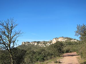
Creu de Santos or Xàquera is the highest mountain of the Serra de Cardó range, Catalonia, Spain. The Serra de Cardó is part of the Massís de Cardó, Catalan Pre-Coastal Range. This mountain has an elevation of 941 metres above sea level.

Tossal Gros de Vallbona is a mountain of the Catalan Central Depression, Catalonia, Spain. It has an elevation of 802 metres above sea level.

Serra de Montsant is a mountain chain in Catalonia, Spain. The main populated area in the range is La Morera de Montsant.

The Catalan Transversal Range is a system of minor mountain ranges at the eastern end of the Pre-Pyrenees, between the Osona and Garrotxa comarques. The existence of the Catalan Transversal Range has made communications in the northern areas of Catalonia difficult in the past, especially between Northeastern Catalonia and Western Catalonia, a problem that has been partly solved with the development of the Eix Transversal.

The Coll de Balaguer is a mountain pass in Catalonia, Spain. It is located at the point where the Catalan Pre-Coastal Range reaches the sea, in L'Almadrava, within the Vandellòs i l'Hospitalet de l'Infant municipality, Baix Camp.

Vallbona de les Monges is a municipality in the comarca of the Urgell in Catalonia, Spain. It is located at the southern end of the comarca, north of the Serra del Tallat, Catalan Pre-Coastal Range, where many wind turbines have been installed.

Serra de Pàndols is a limestone mountain chain located at the southern end of the Catalan Pre-Coastal Range, in Catalonia, Spain.
Serra del Tallat is a mountain range of the Catalan Central Depression, Catalonia, Spain. It has an elevation of 802 metres above sea level.
Prades Mountains, also known as Muntanyes de Prades, is a large calcareous mountain massif straddling the comarcas of Alt Camp, Baix Camp, Conca de Barberà, Garrigues and Priorat, in Catalonia, Spain. They are a Site of Community Importance.
Buinaca or Punta de la Buinaca, also spelt Boinaca, is one of the highest mountains of the Cardó Massif, Catalan Pre-Coastal Range, Catalonia, Spain. This mountain has an elevation of 764 metres above sea level.

Serra de Llaberia is a mountain chain in Catalonia, Spain located between the Prades and the Tivissa-Vandellòs Mountains.

Mola de Colldejou is a mountain chain in Catalonia, Spain located north of the Serra de Llaberia in the Catalan Pre-Coastal Range. The highest point is 921.8 m above sea level.
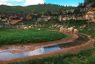
The Gaià is a 59 km long river in Tarragona Province, Catalonia.