
Totnes is a market town and civil parish at the head of the estuary of the River Dart in Devon, England within the South Devon Area of Outstanding Natural Beauty. It is about 21 miles (34 km) south-southwest of Exeter and is the administrative centre of the South Hams District Council.

The Barossa Valley is a valley in South Australia located 60 kilometres (37 mi) northeast of Adelaide city centre. The valley is formed by the North Para River. It is notable as a major wine-producing region and tourist destination.

The River Dart is a river in Devon, England which rises high on Dartmoor, and releases to the sea at Dartmouth.

Yass Valley Council is a local government area in the Southern Tablelands region of New South Wales, Australia. The area is located adjacent to the Hume and Barton Highways and the Main Southern railway line.

South Hams is a local government district on the south coast of Devon, England. Services divide between those provided by its own Council headquartered in Totnes, and those provided by Devon County Council headquartered in the city of Exeter.

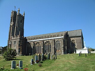
Buckfastleigh is a small market town and civil parish in Devon, England situated beside the Devon Expressway (A38) at the edge of the Dartmoor National Park. It is part of Teignbridge and, for ecclesiastical purposes, lies within the Totnes Deanery. It is 18 miles east-northeast of Plymouth, 20 miles southwest of Exeter and has a population of 3,661. It is a centre of tourism and is home to Buckfast Abbey, the South Devon Railway, the Buckfastleigh Butterfly Farm and Otter Sanctuary, the Tomb of Squire Richard Cabell and The Valiant Soldier.

Clarence Valley Council is a local government area in the Northern Rivers region of New South Wales, Australia.

Nambucca Valley Council is a local government area in the mid north coast region of New South Wales, Australia.
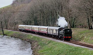
The South Devon Railway is a 6.64 miles (10.69 km) heritage railway from Totnes to Buckfastleigh in Devon. Mostly running alongside the River Dart, it was initially known as the Dart Valley Railway. The railway is now operated by the South Devon Railway Trust, a registered charity.

The Bega Valley Shire is a local government area located adjacent to the south-eastern coastline of New South Wales, Australia. The Shire was formed in 1981 with the amalgamation of the Municipality of Bega, Imlay Shire and Mumbulla Shire. The estimated population as at the 2016 census was 33,253.

Richmond Valley Council (RVC) is a local government area on the Northern Rivers region of north-eastern New South Wales, Australia. RVC services an area of 3,051 square kilometres (1,178 sq mi) and draws its name from the Richmond River, which flows through most of the council area. The area under management is located adjacent to the Bruxner Highway, Pacific Highway, and the North Coast railway line.

Totnes is a Parliamentary constituency represented in the House of Commons of the UK Parliament since December 2019 by Conservative Anthony Mangnall. Mangnall defeated incumbent Dr Sarah Wollaston who had originally been elected as a Conservative but defected to the Liberal Democrats earlier that year.

The suburbs of Canberra are organised into a hierarchy of districts, town centres, group centres, local suburbs and other industrial areas and villages. While these divisions have no formal role in the governance or administration of the city, they formed a basis for the planning and development of the city and are significant to the city's commercial and social activities.

Glenworth Valley is a suburb of the Central Coast Council local government area in the Central Coast region of New South Wales, Australia. About 73 km (45 mi) north of Sydney and 20 km (12 mi) west of Gosford, at the 2016 census it had a population of 10 people. Popran Creek runs through the entire valley and rises in the locality of Central Mangrove and then flows for approximately 24 km in a mostly southern direction till it reaches Mangrove Creek.

South Hams was a county constituency based on the South Hams district of Devon. It returned one Member of Parliament to the House of Commons of the Parliament of the United Kingdom. The constituency was created for the 1983 general election, and abolished for the 1997 general election. The constituency covered a vast part of the English Riviera on the south Devon coast.

Upper Kangaroo River is a small village in the Southern Highlands of New South Wales, Australia, in Shoalhaven City Council. It is located on the Kangaroo River, a tributary of the Shoalhaven River. At the 2016 census, it had a population of 122.
Harberton is a village, civil parish and former manor 3 miles south west of Totnes, in the South Hams District of Devon, England. The parish includes the village of Harbertonford situated on the main A381 road. In the 2001 census the parish had a population of 1,285. The village is a major part of the electoral ward of Avon and Harbourne. At the 2011 census the ward population was 2,217.
Littlehempston is a village and civil parish in the South Hams District of Devon in England consisting of 83 households, with a population of 207 in the parish. It has also been called Little Hempston and Hempston Arundel.
The Rural Municipality of Snipe Lake No. 259 is a rural municipality (RM) in the Canadian province of Saskatchewan within Census Division No. 8 and SARM Division No. 3.

Rob Hopkins is an activist and writer on environmental issues, based in Totnes, England. He is best known as the founder and figurehead of the Transition movement, which he initiated in 2005. Hopkins has written four books on environmentalism and activism.
