Tottleben

Last updated
Tottleben
Location of Tottleben within Unstrut-Hainich-Kreis district
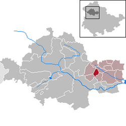
Tottleben in UH.pngBlankenburgKörnerVogtei
Germany adm location map.svg
Red pog.svg
Tottleben
Thuringia location map.svg
Red pog.svg
Tottleben
Coordinates: 51°10′N10°45′E / 51.167°N 10.750°E / 51.167; 10.750 Coordinates: 51°10′N10°45′E / 51.167°N 10.750°E / 51.167; 10.750
Country Germany
State Thuringia
District Unstrut-Hainich-Kreis
Government
   Mayor (202228) Jens Scheidig [1]
Area
  Total5.04 km2 (1.95 sq mi)
Elevation
210 m (690 ft)
Population
 (2020-12-31) [2]
  Total133
  Density26/km2 (68/sq mi)
Time zone UTC+01:00 (CET)
  Summer (DST) UTC+02:00 (CEST)
Postal codes
99947
Dialling codes 036043
Vehicle registration UH
Website www.tottleben.info

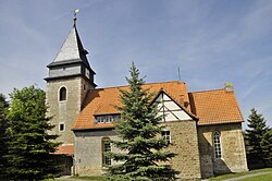
Tottleben is a municipality in the Unstrut-Hainich-Kreis district of Thuringia, Germany.

Contents

Geography

The municipality Tottleben is 7 km away from the western edge of Bad Tennstedt at an altitude of 210–315 meters. Through the village leads the L 2127, which connects Tottleben with the neighboring Großurleben in the southeast and with Kirchheilingen in the northwest.

History

The municipality was mentioned for the first time in 988. The place belonged to 1815 to Saxon Office Langensalza and after his assignment to Prussia from 1816 to 1944 to district Langensalza in the Province of Saxony.

Politics

Council

The local council of Tottleben has 6 members.

(Stand: local elections on June 7, 2009)

Mayor

The honorary mayor Steffen Mörstedt was re-elected on June 6, 2010 [3]

Things

Tottleben-St. Anna Kirche Tottleben-Kirche-1.JPG
Tottleben-St. Anna Kirche

The most striking sight in the area is the village church of St. Anna. The parish is part of the parish Kirchheilingen. The most famous son of the place was Gottlieb Heinrich Totleben (1715-1773), officer, general and adventurer, who was in Saxon and Russian service.

Related Research Articles

Unstrut-Hainich-Kreis is a Kreis (district) in the north of Thuringia, Germany. Neighboring districts are the districts Eichsfeld, Kyffhäuserkreis, Sömmerda, Gotha, Wartburgkreis and the district Werra-Meißner in Hesse.

Wartburgkreis is a Kreis (district) in the west of Thuringia, Germany. Neighboring districts are the districts Unstrut-Hainich-Kreis, Gotha, Schmalkalden-Meiningen, and the districts Fulda, Hersfeld-Rotenburg and Werra-Meißner-Kreis in Hesse.

<span class="mw-page-title-main">Bad Langensalza</span> Town in Thuringia, Germany

Bad Langensalza is a spa town of 17,500 inhabitants in the Unstrut-Hainich district, Thuringia, central Germany.

<span class="mw-page-title-main">Dieterode</span> Municipality in Thuringia, Germany

Dieterode is a municipality in the district Eichsfeld, Thuringia, Germany. It is part of the municipal association Ershausen/Geismar.

<span class="mw-page-title-main">Jonaswalde</span> Municipality in Thuringia, Germany

Jonaswalde is a municipality in the Thuringian district of Altenburger Land. It belongs to the Verwaltungsgemeinschaft of Oberes Sprottental.

<span class="mw-page-title-main">Thonhausen</span> Municipality in Thuringia, Germany

Thonhausen is a municipality in the district of Altenburger Land in Thuringia, Germany. It belongs to the Verwaltungsgemeinschaft of Oberes Sprottental.

<span class="mw-page-title-main">Hirschberg, Thuringia</span> Town in Thuringia, Germany

Hirschberg is a town in the Saale-Orla-Kreis district, in Thuringia, Germany. It is situated on the river Saale, 20 km south of Schleiz, 12 km northwest of Hof (Bavaria), and 25 km southwest of Plauen (Saxony).

<span class="mw-page-title-main">Orlamünde</span> Town in Thuringia, Germany

Orlamünde is a small town in the Saale-Holzland district, in Thuringia, Germany. It is part of the Verwaltungsgemeinschaft Südliches Saaletal.

<span class="mw-page-title-main">Großengottern</span> Ortsteil of Unstrut-Hainich in Thuringia, Germany

Großengottern is a village and a former municipality in the Unstrut-Hainich-Kreis district of Thuringia, Germany. Since 1 January 2019, it is part of the municipality of Unstrut-Hainich.

<span class="mw-page-title-main">Bruchstedt</span> Municipality in Thuringia, Germany

Bruchstedt is a municipality in the Unstrut-Hainich-Kreis district of Thuringia, Germany.

<span class="mw-page-title-main">Kirchheilingen</span> Municipality in Thuringia, Germany

Kirchheilingen is a municipality in the Unstrut-Hainich-Kreis district of Thuringia, Germany.

<span class="mw-page-title-main">Westhausen, Hildburghausen</span> Municipality in Thuringia, Germany

Westhausen is a municipality in the region Heldburger Land in the district of Hildburghausen, in Thuringia, Germany.

<span class="mw-page-title-main">Schweickershausen</span> Municipality in Thuringia, Germany

Schweickershausen is a municipality in the region Heldburger Land in the district of Hildburghausen, in Thuringia, Germany.

<span class="mw-page-title-main">Nohra, Thuringia</span> Ortsteil of Bleicherode in Thuringia, Germany

Nohra is a village and a former municipality in the district of Nordhausen, in Thuringia, Germany. As of 2018, Nohra had a population of 799.

<span class="mw-page-title-main">Weißbach, Thuringia</span> Municipality in Thuringia, Germany

Weißbach is a municipality in the district Saale-Holzland, in Thuringia, Germany. The name of the location was vouched first about 1400, according to other sources in 1072. Meat production is dominating in local business.

Unstrut-Hainich-Kreis II is an electoral constituency represented in the Landtag of Thuringia. It elects one member via first-past-the-post voting. Under the current constituency numbering system, it is designated as constituency 9. It covers the central, southern, and eastern part of Unstrut-Hainich-Kreis.

<span class="mw-page-title-main">Höngeda</span> Ortsteil of Mühlhausen in Thuringia, Germany

Höngeda is a village and quarter of the town of Mühlhausen in Thuringia, central Germany.

<span class="mw-page-title-main">Bollstedt</span> Ortsteil of Mühlhausen in Thuringia, Germany

Bollstedt is a village and a quarter of the town of Mühlhausen in Thuringia, central Germany, situated on the left bank of the Unstrut.

<span class="mw-page-title-main">Grabe, Mühlhausen</span> Ortsteil of Mühlhausen in Thuringia, Germany

Grabe is a village and a quarter of the town of Mühlhausen in Thuringia, central Germany. It consists of the settlements Kleingrabe and Großgrabe.

<span class="mw-page-title-main">Nägelstedt</span> Ortsteil of Bad Langensalza in Thuringia, Germany

Nägelstedt is a village and a quarter of the town of Bad Langensalza in Thuringia, central Germany, with about 700 inhabitants.

References

  1. Gewählte Bürgermeister - aktuelle Landesübersicht, Freistaat Thüringen, accessed 10 November 2022.
  2. "Bevölkerung der Gemeinden, erfüllenden Gemeinden und Verwaltungsgemeinschaften in Thüringen Gebietsstand: 31.12.2020". Thüringer Landesamt für Statistik (in German). June 2021.
  3. "Kommunalwahlen in Thüringen am 6. Juni 2010. Wahlen der Gemeinde- und Stadtratsmitglieder. Vorläufige Ergebnisse" (in German). Der Landeswahlleiter.