
Jerilderie Shire was a local government area in the Murray region of southern New South Wales, Australia. The Shire was located adjacent to the Newell Highway. The Shire was declared in 1918 after the amalgamation of the former Municipality of Jerilderie and Wunnamurra Shire. It was dissolved in 2016 after its amalgamation with Murrumbidgee Shire to create Murrumbidgee Council
The Greater Taree City Council (GTCC) was a local government area on the Mid North Coast of New South Wales, Australia, until 12 May 2016 when it was amalgamated to form part of the Mid-Coast Council. It was originally formed in 1981 from the Manning Shire, and the Taree and Wingham Municipal Councils. The council was centred on Taree, located adjacent to the Manning River, the Pacific Highway and the North Coast railway line.

Berrigan Shire is a local government area in the southern Riverina region of New South Wales, Australia. The Shire lies on the New South Wales State border with Victoria formed by the Murray River. The Shire is adjacent to the Newell and Riverina Highways. The Shire is a mainly agricultural region, with dairying, cattle raising, woolgrowing and cropping the main activities. The vast majority of the Shire is irrigated. Tourism is another major activity, concentrated on the river towns of Tocumwal and Barooga.
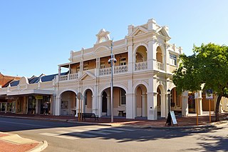
The Shire of Narrogin is a local government area in the Wheatbelt region of Western Australia, about 190 kilometres (118 mi) south-east of the state capital, Perth. The seat of government is in the town of Narrogin. Until 2016, when the two entities merged, the Narrogin townsite was governed by a separate local government area, the Town of Narrogin.

Blayney Shire is a local government area in the Central West region of New South Wales, Australia. The Shire is located adjacent to the Mid-Western Highway and the Main Western railway line, and is centred on the town of Blayney.

The Shire of Northam is a local government area in the Wheatbelt region of Western Australia, beyond the northeastern fringe of the Perth metropolitan area centred on the town of Northam itself. The Shire covers an area of 1,431 square kilometres (553 sq mi). In 2007, it merged with the Town of Northam, almost tripling its population in the process from a previous size of 3,794.

Walcha Shire is a local government area located in the New England region of New South Wales, Australia. The Shire is situated adjacent to the junction of the Oxley Highway and Thunderbolts Way and is 20 kilometres (12 mi) east of the Main North railway line passing through Walcha Road. The shire was formed on 1 June 1955 through the amalgamation of Apsley Shire and the Municipality of Walcha.

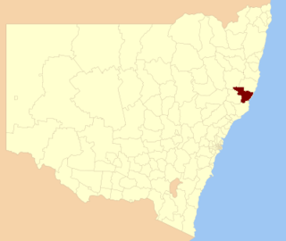
Dungog Shire is a local government area in the Hunter region of New South Wales, Australia. The Shire is situated adjacent to the Barrington Tops and consists predominantly of very rugged to hilly country which becomes less rugged from north to south.

Young Shire was a local government area in the South West Slopes region of New South Wales, Australia. The Shire was located adjacent to the Olympic Highway.

Harden Shire was a local government area in the South West Slopes region of New South Wales, Australia. The Shire included the twin towns of Harden and Murrumburrah and the small towns of Galong, Jugiong, Wombat and Kingsvale.

Lockhart Shire is a local government area in the Riverina region of New South Wales, Australia. The Shire was created in 1906 and is an agricultural and pastoral area.

The Shire of Tammin is a local government area in the Wheatbelt region of Western Australia. Its seat of government is the town of Tammin, about 80 kilometres (50 mi) west of Merredin and about 180 kilometres (112 mi) east of Perth, the state capital.

The City of Geraldton was a local government area in the Mid West region of Western Australia, 424 kilometres (263 mi) north of the state capital, Perth on the Indian Ocean. The City covered an area of 46.3 square kilometres (17.9 sq mi), and its seat of government was the town of Geraldton.
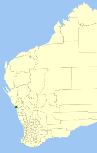
The Shire of Greenough was a local government area in the Mid West region of Western Australia, 420 kilometres (261 mi) north of the state capital, Perth surrounding the city of Geraldton. The Shire covered an area of 1,752 square kilometres (676.5 sq mi), and its seat of government was the outer Geraldton suburb of Utakarra.
The City of Geraldton-Greenough was a local government area in the Mid West region of Western Australia, 424 kilometres (263 mi) north of the state capital, Perth on the Indian Ocean. It covered an area of 1,798.3 square kilometres (694.3 sq mi), and its seat of government was the town of Geraldton.
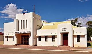
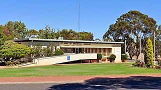
The Shire of Morawa is a local government area in the Mid West region of Western Australia, about 170 kilometres (106 mi) east-southeast of the city of Geraldton and about 390 kilometres (242 mi) north of the state capital, Perth. The Shire covers an area of 3,516 square kilometres (1,358 sq mi), and its seat of government is the town of Morawa.
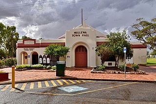
The Shire of Mullewa was a local government area in the Mid West region of Western Australia, about 100 kilometres (62 mi) east of the city of Geraldton and about 450 kilometres (280 mi) north of the state capital, Perth. The Shire covered an area of 10,827 square kilometres (4,180 sq mi), and its seat of government was the town of Mullewa. It amalgamated with the City of Geraldton-Greenough on 1 July 2011 to become part of the City of Greater Geraldton.

The Shire of Perenjori is a local government area in the Mid West region of Western Australia, about 360 kilometres (224 mi) north of the state capital, Perth. The Shire covers an area of 8,313 square kilometres (3,210 sq mi), and its seat of government is the town of Perenjori.
The Shire of Broomehill-Tambellup is a local government area in the Great Southern region of Western Australia, 320 kilometres (200 mi) south-southeast of the state capital, Perth. The Shire covers an area of 2,609.1 square kilometres (1,007.4 sq mi), and its seat of government is the town of Tambellup. It came into existence in 2008 through the amalgamation of the former Shire of Broomehill and Shire of Tambellup.

The City of Greater Geraldton is a local government area in the Mid West region of Western Australia, 424 kilometres (263 mi) north of the state capital, Perth on the Indian Ocean. It covers an area of 12,625.5 square kilometres (4,874.7 sq mi), and its seat of government is the town of Geraldton.
