
Abel Janszoon Tasman was a Dutch seafarer, explorer, and merchant, best known for his voyages of 1642 and 1644 in the service of the Dutch East India Company (VOC). He was the first known European explorer to reach New Zealand and the islands of Fiji and Van Diemen's Land.

Batavia was a ship of the Dutch East India Company (VOC). Built in Amsterdam in 1628 as the company's new flagship, she sailed that year on her maiden voyage for Batavia, capital of the Dutch East Indies. On 4 June 1629, Batavia was wrecked on the Houtman Abrolhos, a chain of small islands off the western coast of Australia.

Batavia is a historical and geographical region in the Netherlands, forming large fertile islands in the river delta formed by the waters of the Rhine and Meuse rivers. During the Roman empire, it was an important frontier region and source of imperial soldiers. Its name is possibly pre-Roman.

The maritime European exploration of Australia consisted of several waves of European seafarers who sailed the edges of the Australian continent. Dutch navigators were the first Europeans known to have explored and mapped the Australian coastline. The first documented encounter was that of Dutch navigator Willem Janszoon, in 1606. Dutch seafarers also visited the west and north coasts of the continent, as did French explorers.

Dirk Hartog was a 17th-century Dutch sailor and explorer. Dirk Hartog's expedition was the second European group to land in Australia and the first to leave behind an artefact to record his visit, the Hartog Plate. His name is sometimes alternatively spelled Dirck Hartog or Dierick Hartochszch. Ernest Giles referred to him as Theodoric Hartog. The Western Australian island Dirk Hartog Island is named after Hartog.
The human history of Western Australia commenced between 40,000 and 60,000 years ago with the arrival of Indigenous Australians on the northwest coast. The first inhabitants expanded across the east and south of the continent.

Willem Hesselsz de Vlamingh was a Dutch sea captain who explored the central west coast of New Holland (Australia) in the late 17th century, where he landed in what is now Perth on the Swan River. The mission proved fruitless, but he charted parts of the continent's western coast.
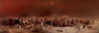
Jeronimus Cornelisz was a Frisian-Dutch apothecary and Dutch East India Company merchant who sailed aboard the merchant ship Batavia which foundered near Australia. Cornelisz then led one of the bloodiest mutinies in history.

A castaway is a person who is cast adrift or ashore. While the situation usually happens after a shipwreck, some people voluntarily stay behind on a deserted island, either to evade captors or the world in general. A person may also be left ashore as punishment (marooned).
François Thijssen or Frans Thijsz was a Dutch-French explorer who explored the southern coast of Australia.

Sir Charles Hardy Islands is in the reef of the same name adjacent to Pollard Channel & Blackwood Channel about 40 km east of Cape Grenville off Cape York Peninsula.

Booby Island is located 45 km (28 mi) northwest of Muttee Heads at the tip of Cape York Peninsula in Queensland, Australia. This island is in the Torres Strait, 32 km (20 mi) west of Thursday Island and 23 km (14 mi) west of Prince of Wales Island. Booby Island is also known as Ngiangu by the Kuarareg people of the western Torres Strait, its traditional owners, named for the giant Ngiangu who was forced from a neighbouring island It has been called Booby Island by a number of European explorers, including Captain Cook, for the presence of the booby birds.

Herman Diedrich Spöring Jr. (1733–1771) was a Finnish explorer, draughtsman, botanist and a naturalist.
28°28′S113°42′E

Batavia Road was a passenger boat used from 1946 for commercial tourist operation in the Houtman Abrolhos, a group of islands off the coast of Western Australia.
In fact the Batavia was wrecked in the Wallabi Group, 60 kilometres (40 mi) to the north. The wreckage seen by the Beagle was either that of the Zeewyk, or the unidentified wreck seen by the Zeewyks crew. The name Batavia Road is thus a misnomer, as are a number of other places named by Stokes, including Pelsaert Island, the Pelsaert Group, and Wreck Point. Stokes' erroneous view was accepted without question for over fifty years, and it has been claimed that the confusion caused the discovery of the Batavia shipwreck to be set back by over a century.
Lady Elliot was a ship that was probably wrecked off the coast near Cardwell, Queensland, Australia in 1816. It was a ship of 353 tons and had been constructed in Bengal, India, completed in 1815.

Wiebbe Hayes was a Dutch soldier known for his leading role in the suppression of the murderous mutiny led by Jeronimus Cornelisz in 1629, after the merchant ship Batavia was wrecked in the Houtman Abrolhos, a chain of coral islands off the west coast of Australia.

Max Cramer OAM was an Australian scuba diver who became famous as the co-discoverer of the wreck of the Batavia on 4 June 1963. He was involved in a number of maritime archaeology projects pertaining to historic shipwrecks in Western Australia.

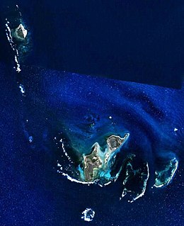
The Wiebbe Hayes Stone Fort on West Wallabi Island is the oldest surviving European building in Australia and was built by survivors of the Batavia shipwreck and massacre. West Wallabi Island is 63 km (39 mi) from the coast of Western Australia.
