There are many forms of transport in Lethbridge, Alberta, Canada, including highways and public transit. Lethbridge's airport is Lethbridge Airport (YQL), which is south of the city boundary. Lethbridge also has an intricate cycling-and-pedestrian pathway that meets several destinations in the city, including the urban park system in the Oldman River valley.
In 2003, Lethbridge College conducted a public opinion survey regarding commuting choice in Lethbridge.[1] This survey found that less than 20% of Lethbridge residents regularly used the public transit system.
In 2006, the Lethbridge Public Library released a study that stated in part up to 130,000 people commute to Lethbridge from a radius of 100km (62mi).[2] Since the local public transit system does not extend outside city boundaries, presumably these commuters use automobiles.[citation needed]
Public transit
The downtown Lethbridge transit terminal allows the buses to stop curbside to transfer passengers between routes
Mass transit in Lethbridge consists of 40 buses (with an average age of 10 years) covering most of the city on 16 routes and managed by Lethbridge Transit. Traditionally, all bus routes in the city started and ended downtown. In the early 21st century, however, cross-town and shuttle routes were introduced. For example, there is now service from the University of Lethbridge to Lethbridge College, University of Lethbridge to the North Lethbridge terminal, and from Lethbridge College to the North Lethbridge terminal. Two of those routes make brief stops downtown.
The transit system does not use zone fares, and the cost of fare is the same regardless of the number of transfers made. Buses meet at four transit terminals: downtown, University of Lethbridge, Lethbridge College, and the North Lethbridge terminal. Although not a terminal, several routes also converge near the Chinook Regional Hospital.
In addition to the transit system, Lethbridge has several taxicab and limousine companies offering service throughout the city and to destinations outside city limits (including the Lethbridge Airport). Lethbridge also has a Red Arrow depot, providing bus service to Calgary.[3]
The Parks and Recreation department maintains the citywide 30-kilometre (19mi) pedestrian-and-cyclist Coal Banks Trail system (map). The system was designed to connect the Oldman River valley with other areas of the city, including Pavan Park in the north, Henderson Park in the east, Highways4 and 5 in the south, and a loop in West Lethbridge (including University Drive and McMaster Blvd).
Rail service
Lethbridge is very close to the CPR rail yards in Kipp. The rail yards were moved to Kipp, just west of the city, from downtown Lethbridge in 1983 to make way for commercial expansion.
The city is on a mainline of the Canadian Pacific Railway with trackage east to Toronto, south to the United States, west to Vancouver, and north to Calgary. Despite the marshalling yard being in Kipp, there are full freight-handling facilities in the city. In addition, spur trackage serves the industrial areas, and a rail-loading facility is available to all businesses.
Rail service in Lethbridge includes the well known Lethbridge Viaduct or High Level Bridge. It is one of the highest and longest steel railway truss bridges in the world.
Passenger rail service stopping in Lethbridge was discontinued in 1971 by CPR.[citation needed]
Airport
The Lethbridge Airport provides commercial flights to Calgary, as well as private and charter flights to other destinations. The airport provides customs services for any flights coming in from the United States. The airport is 2km (1mi) south of the city, on Highway5.[4]
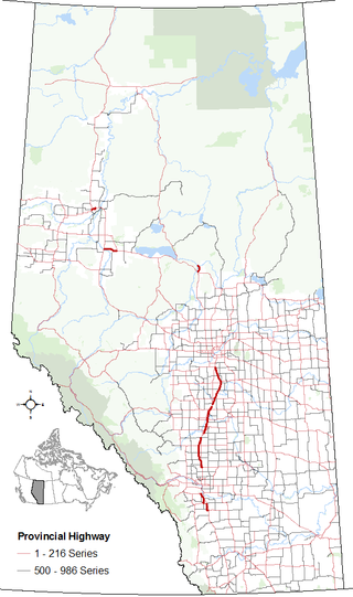
Four provincial highways (3, 4, 5, and 25) run through or terminate in Lethbridge. This has led to the creation of major arterial roads (including Mayor Magrath Drive, University Drive and Scenic Drive) and an expressway (Crowsnest Trail). This, and the fact Lethbridge is on the CANAMEX Corridor, has led to Lethbridge being a major shipping destination, with over a dozen trucking firms having depots in the city.[4]
Lethbridge is approximately 100km (62mi) north of the United States border via Highways4 and 5; and 210km (130mi) south of Calgary via Highways 2 and 3. Highways2, 3 and 4 form part of the CANAMEX trade route between Mexico, the United States, and Canada.[4]
Highway5 leads out to the Lethbridge Airport, satellite communities (such as Magrath and Welling), Waterton Lakes National Park, and the Canada-United States border via Highway2. In the city limits, it intersects with Highway4 and becomes Mayor Magrath Drive, which later intersects with Crowsnest Trail.
Highway4 leads out to satellite communities (such as Stirling and Warner) and the Canada-United States border, where it meets Interstate 15, connecting eventually to Salt Lake City, Las Vegas and San Diego. In the city limits, it intersects with Highway5 and becomes Scenic Drive, which later intersects with Whoop-up Drive (the busiest road in Lethbridge) and Crowsnest Trail.
Highway 3—also known as the Crowsnest Highway—provides east–west service to British Columbia and Medicine Hat, where it meets up with the Trans-Canada Highway. Fort Macleod is only 51km (32mi) west of Lethbridge and provides service to Calgary via Highway2. Several satellite communities (such as Coalhurst and Coaldale) are located on Highway3. Of all the highways servicing Lethbridge, only Highway 3 does not terminate in the city.
Highway 25 provides service to satellite communities (such as Picture Butte and Diamond City). In the city, the highway turns into University Drive and services a major retail centre and the University of Lethbridge. It intersects with Whoop-up Drive and the Crowsnest Highway.
A long-term plan would involve construction of a freeway bypass north and east of Lethbridge, from Monarch on existing Highway 3 east across Highway 25, the Oldman River, then south to cross Highway 3 between Coaldale and Lethbridge, and join Highway 4 southeast of Lethbridge. No timeline for construction has been established.[5]
Major roads
Lethbridge road network
The following are arterial and collector roads in Lethbridge. The numbers listed are the maximum number of vehicle traffic during weekdays for 2010.[6] Only roads reaching at least 6,000 vehicles per day, which is the cut off for a "major collector" classification, are listed below.
Since 2000, several major infrastructure projects have been implemented in the city to accommodate current and planned traffic use. From 2001 to 2005, Mayor Magrath Drive, the second busiest roadway in Lethbridge, was upgraded to six lanes from 3 Avenue South to 34 Avenue South.
In 2006, Whoop-up Drive, the busiest roadway in the city, was extended to 24 Avenue West. This extension provided direct service for the residential community of Sunset Acres and service for The Crossings, the planned commercial core of West Lethbridge, and the residential neighbourhood of Copperwood. In addition, University Drive was widened from Whoop-up Drive to the location of the proposed sports arena, making the roadway six lanes in areas, including multiple turning lanes onto access roads for the University of Lethbridge.
In the fall of 2013, Scenic Drive was extended from 9th Avenue North to meet Stafford Drive North and continuing north out of the city. Current projects are improving capacity along a route comprising Mayor Magrath Drive North (from the CPR underpass to 5th Avenue), 5th Avenue North (from Mayor Magrath to 28th Street), and 28th Street North (from 5th Avenue northward).
In regard to future projects, discussions have taken place regarding the creation of Metis Trail in West Lethbridge (paralleling University Drive) and Chinook Trail, a ring-road intersecting with Crowsnest Trail on the Westside and connecting with 43 Street South in the east. Chinook Trail would include a third crossing of the Oldman River.
Lethbridge is a city in the province of Alberta, Canada. With a population of 106,550 in the 2023 municipal census. Lethbridge became the fourth Alberta city to surpass 100,000 people. The nearby Canadian Rocky Mountains contribute to the city's warm summers, mild winters, and windy climate. Lethbridge lies southeast of Calgary on the Oldman River.
The Crowsnest Highway is an east-west highway in British Columbia and Alberta, Canada. It stretches 1,161 km (721 mi) across the southern portions of both provinces, from Hope, British Columbia to Medicine Hat, Alberta, providing the shortest highway connection between the Lower Mainland and southeast Alberta through the Canadian Rockies. Mostly two-lane, the highway was officially designated in 1932, mainly following a mid-19th-century gold rush trail originally traced out by an engineer named Edgar Dewdney. It takes its name from the Crowsnest Pass, the location at which the highway crosses the Continental Divide between British Columbia and Alberta.
Alberta Provincial Highway No. 2, commonly referred to as Highway 2 or the Queen Elizabeth II Highway, is a major highway in Alberta that stretches from the Canada–United States border through Calgary and Edmonton to Grande Prairie. Running primarily north to south for approximately 1,273 kilometres (791 mi), it is the longest and busiest highway in the province carrying more than 170,000 vehicles per day near Downtown Calgary. The Fort Macleod—Edmonton section forms a portion of the CANAMEX Corridor that links Alaska to Mexico. More than half of Alberta's 4 million residents live in the Calgary–Edmonton Corridor created by Highway 2.
Alberta Provincial Highway No. 2A is the designation of six alternate routes off Highway 2 in Alberta, Canada. In general, these are original sections of Highway 2, such as the southern portion of Macleod Trail in Calgary. They passed through communities before limited-access freeways were built to shorten driving distance, accommodate heavier volumes and to bypass city traffic. Portions of the alignment of Highway 2A follow the route of the former Calgary and Edmonton Trail.
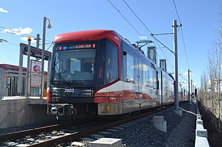
Chinook station is a CTrain light rail station in Manchester Industrial, Calgary, Alberta. The station opened on May 25, 1981, as part of the original South line on the Red Line.
Alberta Provincial Highway No. 3, commonly referred to as Highway 3 and officially named the Crowsnest Highway, is a 324-kilometre (201 mi) highway that traverses southern Alberta, Canada, running from the Crowsnest Pass through Lethbridge to the Trans-Canada Highway in Medicine Hat. Together with British Columbia Highway 3 which begins in Hope, it forms an interprovincial route that serves as an alternate to the Trans-Canada from the Lower Mainland to the Canadian Prairies.
Stirling is a village in southern Alberta, Canada that is surrounded by the County of Warner No. 5. The village is located on Highway 4, approximately 31 km (19 mi) southeast of Lethbridge and 72 km (45 mi) northwest of the Canada–US border.
Alberta Provincial Highway No. 4, commonly referred to as Highway 4, is a 103-kilometre (64 mi) highway in southern Alberta, Canada that connects Highway 3 in Lethbridge to Interstate 15 in Montana. The highway was designated in 1999 as the First Special Service Force Memorial Highway in honour of elite soldiers who travelled to Helena, Montana for training before World War II. The highway continues into the United States retaining that name.
Alberta Provincial Highway No. 5, commonly referred to as Highway 5, is a 129-kilometre (80 mi) highway that connects Lethbridge to Waterton Lakes National Park in southern Alberta, Canada. It begins as an east–west highway in Waterton and transitions to a north–south route before ending at Crowsnest Trail (Highway 3) in Lethbridge.
Transportation in the Canadian city of Toronto forms the hub of the road, rail and air networks in the Greater Toronto Area and much of southern Ontario. There are many forms of transport in the city, including railways, highways, and public transit. Toronto also has an extensive network of bicycle lanes and multi-use trails and paths.
The city of Calgary, Alberta, has a large transportation network that encompasses a variety of road, rail, air, public transit, and pedestrian infrastructure. Calgary is also a major Canadian transportation centre and a central cargo hub for freight in and out of north-western North America. The city sits at the junction between the "Canamex" highway system and the Trans-Canada Highway.
Mayor Magrath Drive is the busiest north–south roadway and the second busiest roadway overall in Lethbridge, Alberta. In 2011, it saw roughly 34,000 vehicles per day in weekday traffic. Most retail and hospitality establishments in the city are concentrated on this roadway, and it serves as a major transportation corridor for the city and region.
Downtown Lethbridge is the central business district of Lethbridge, Alberta, Canada, hosting most of the city's banks and several accounting and law practices, including national firms.
Transport in Edmonton is fairly typical for a Canadian city of its size, involving air, rail, road and public transit. With very few natural barriers to growth and largely flat to gently rolling terrain bisected by a deep river valley, the city of Edmonton has expanded to cover an area of nearly 768 km2 (297 sq mi), of which only two-thirds is built-up, while the metropolitan area covers around 9,430 km2 (3,640 sq mi).
Alberta Provincial Highway No. 3A, commonly referred to as Highway 3A, is the designation of four alternate routes of Highway 3 in southern Alberta, Canada. All four segments are former alignments of Highway 3, also known as the Crowsnest Highway.
West Lethbridge, is one of three geographical areas in Lethbridge, Alberta, Canada. It is the newest and the fastest growing. It is the home of the University of Lethbridge and is a residential area primarily.
The Red Coat Trail is a 1,300-kilometre (810 mi) route that approximates the path taken in 1874 by the North-West Mounted Police in their March West from Fort Dufferin to Fort Whoop-Up.
16 Avenue N is a major road in Calgary, Alberta, that forms a 26.5-kilometre (16.5 mi) segment of Highway 1 and connects Calgary to Banff and Medicine Hat. It is a four to six-lane principal arterial expressway at its extremities, but is an urban arterial road between the Bow River and Bowness Road, and also between Crowchild Trail and Deerfoot Trail. Due to Calgary's quadrant system, it is known as 16 Avenue NW west of Centre Street and 16 Avenue NE to the east.
The Blue Line, also known as Route 202, is a light rail transit (LRT) line in Calgary, Alberta, Canada. Partnered with the Red Line, and future Green Line it makes up Calgary's CTrain network. Following its initial approval in 1976, the Red Line opened in 1981, with the first trains running on what is now the Blue Line in 1985.
This page is based on this Wikipedia article Text is available under the CC BY-SA 4.0 license; additional terms may apply. Images, videos and audio are available under their respective licenses.