
The federative units of Brazil are subnational entities with a certain degree of autonomy and endowed with their own government and constitution, which together form the Federative Republic of Brazil. There are 26 states and one federal district. The states are generally based on historical, conventional borders which have developed over time. The states are divided into municipalities, while the Federal District assumes the competences of both a state and a municipality.
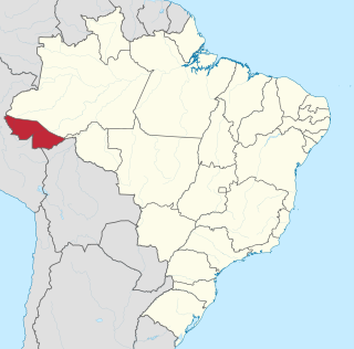
Acre is a state located in the west of the North Region of Brazil and the Amazonia Legal. Located in the westernmost part of the country, at a two-hour time difference from Brasília, Acre is bordered clockwise by the Brazilian states of Amazonas and Rondônia to the north and east, along with an international border with the Bolivian department of Pando to the southeast, and the Peruvian regions of Madre de Dios, Ucayali and Loreto to the south and west. Its capital and largest city is Rio Branco. Other important places include Cruzeiro do Sul, Sena Madureira, Tarauacá and Feijó. The state, which has 0.42% of the Brazilian population, generates 0.2% of the Brazilian GDP.

Amazonas is a state of Brazil, located in the North Region in the north-western corner of the country. It is the largest Brazilian state by area and the ninth-largest country subdivision in the world. It is the largest country subdivision in South America, being greater than the areas of Chile, Paraguay, and Uruguay combined. Mostly located in the Southern Hemisphere, Amazonas is the third-largest country subdivision in the Southern Hemisphere after the Australian states of Western Australia and Queensland. Located entirely in the Western Hemisphere, it is the fourth-largest country subdivision in the Western Hemisphere after Greenland, Nunavut, and Alaska. If independent, Amazonas could become the sixteenth-largest country in the world, slightly larger than Mongolia. Neighbouring states are Roraima, Pará, Mato Grosso, Rondônia, and Acre. It also borders the nations of Peru, Colombia and Venezuela. This includes the Departments of Amazonas, Vaupés and Guainía in Colombia, as well as the Amazonas state in Venezuela, and the Loreto Region in Peru.

José Maria da Silva Paranhos Júnior, 2nd Viscount of Rio Branco was a Brazilian noble, diplomat, geographer, historian, politician and professor, considered to be the "father of Brazilian diplomacy". He was the son of statesman José Paranhos, Viscount of Rio Branco. The Baron of Rio Branco was a member of the Brazilian Academy of Letters, occupying its 34th chair from 1898 until his death in 1912. As a representative of Brazil, he managed to peacefully resolve all Brazil's border disputes with its South American neighbours and incorporate 900 thousand square kilometers through his diplomacy alone.
Galvez – Imperador do Acre is a book published in 1976 by Brazilian author Márcio Souza about an episode in the history of Acre State (Brazil). This short novel mixes the historical novel and feuilleton styles. The book was a great success in the eighties.

The Riograndense Republic, often called the Piratini Republic, was a de facto state that seceded from the Empire of Brazil and roughly coincided with the present state of Rio Grande do Sul. It was proclaimed on 11 September 1836 by general Antônio de Sousa Neto as a direct consequence of the victory obtained by gaúcho oligarchic forces at the Battle of Seival (1836) during the Ragamuffin War (1835–1845). It had a constitution adopted in 1843 and was recognised only by the United Kingdom, France, and Uruguay.
The Treaty of Petrópolis, signed on November 11, 1903, in the Brazilian city of Petrópolis, ended the Acre War between Bolivia and Brazil over the then-Bolivian territory of Acre, a desirable territory in Bolivia-Brazil border during the contemporary rubber boom.

José Manuel Inocencio Pando Solares was a Bolivian soldier and explorer who served as the 25th President of Bolivia from 1899 to 1904. During his government, the Acre War (1899-1903) began, in which Bolivia clashed with Brazil.

The Acre River is a 680 kilometres (420 mi) long river in central South America.

Porto Acre is a municipality located in the northeast of the Brazilian state of Acre. The economy is mainly based on agriculture. As of 2020 the municipality had an estimated population of 18,824.

The Republic of Acre or the Independent State of Acre were the names of a series of separatist governments in then Bolivia's Acre region between 1899 and 1903. The region was eventually annexed by Brazil in 1903 and is now the State of Acre.

The Acre War, known in Brazil as Acrean Revolution and in Spanish as Guerra del Acre was a border conflict between Bolivia and the First Brazilian Republic over the Acre Region, which was rich in rubber and gold deposits. The conflict had two phases between 1899 and 1903 and ended with an Acrean victory and the subsequent Treaty of Petrópolis, which ceded Acre to Brazil. The outcome also affected territories disputed with Peru.

Events in the year 1899 in Brazil.
The Bolivia–Brazil border is the international border between the territories of Bolivia and Brazil. It extends from Corumbá, Mato Grosso do Sul, to Assis Brasil, in Acre.

José Plácido de Castro was a Brazilian soldier, surveyor, rubber producer and politician who led the armed revolt during the Acre War of 1902–3, when the Republic of Acre broke away from Bolivia. He was the president of the state of Acre just before and after it was purchased by Brazil. After the war he became extremely wealthy as a rubber producer, and made many enemies. He was assassinated in 1908. He is considered a hero of Brazil.
Silvério José Nery was a Brazilian soldier and politician who was a federal deputy from 1897 to 1899, governor of the state of Amazonas from 1900 to 1903 and a senator from 1904 to 1930.

Luis Gálvez Rodríguez de Arias (1864-1935) was a Spanish journalist, diplomat and adventurer who proclaimed the Republic of Acre in 1899. He ruled Acre between July 14, 1899 and January 1, 1900 for the first time, and between January 30 and March 15, 1900, for the second and last time.

The Colombian–Peruvian territorial dispute was a territorial dispute between Colombia and Peru, which, until 1916, also included Ecuador. The dispute had its origins on each country's interpretation of what Real Cedulas Spain used to precisely define its possessions in the Americas. After independence, all of Spain's former territories signed and agreed to proclaim their limits in the basis of the principle of uti possidetis juris, which regarded the Spanish borders of 1810 as the borders of the new republics. However, conflicting claims and disagreements between the newly formed countries eventually escalated to the point of armed conflicts on several occasions.

The Bolivian–Peruvian territorial dispute was a territorial dispute between Bolivia and Peru that lasted from the former's independence in 1825 to the signing of the Polo–Bustamante Treaty in 1909.
The History of Acre refers to the history of the Brazilian northern state, and also reveals important aspects of Brazilian history, especially during the 19th and 20th centuries.
