
Gardening is the practice of growing and cultivating plants as part of horticulture. In gardens, ornamental plants are often grown for their flowers, foliage, or overall appearance; useful plants, such as root vegetables, leaf vegetables, fruits, and herbs, are grown for consumption, for use as dyes, or for medicinal or cosmetic use.

Ashdown Forest is an ancient area of open heathland occupying the highest sandy ridge-top of the High Weald Area of Outstanding Natural Beauty. It is situated some 30 miles (48 km) south of London in the county of East Sussex, England. Rising to an elevation of 732 feet (223 m) above sea level, its heights provide expansive vistas across the heavily wooded hills of the Weald to the chalk escarpments of the North Downs and South Downs on the horizon.

Bocage is a terrain of mixed woodland and pasture characteristic of parts of Northern France, Southern England, Ireland, the Netherlands and Northern Germany, in regions where pastoral farming is the dominant land use.

Rathcroghan is a complex of archaeological sites near Tulsk in County Roscommon, Ireland. It is identified as the site of Cruachan, the traditional capital of the Connachta, the prehistoric and early historic rulers of the western territory. The Rathcroghan Complex is a unique archaeological landscape with many references found in early Irish medieval manuscripts.

Falmer is a small village and civil parish in the Lewes District of East Sussex, England, lying between Brighton and Lewes, approximately five miles (8 km) north-east of the former. It is also the site of Brighton & Hove Albion's Falmer Stadium.

A hedge or hedgerow is a line of closely spaced shrubs and sometimes trees, planted and trained to form a barrier or to mark the boundary of an area, such as between neighbouring properties. Hedges that are used to separate a road from adjoining fields or one field from another, and are of sufficient age to incorporate larger trees, are known as hedgerows. Often they serve as windbreaks to improve conditions for the adjacent crops, as in bocage country. When clipped and maintained, hedges are also a simple form of topiary.

In landscaping, an avenue, alameda, or allée, is traditionally a straight path or road with a line of trees or large shrubs running along each side, which is used, as its Latin source venire indicates, to emphasize the "coming to," or arrival at a landscape or architectural feature. In most cases, the trees planted in an avenue will be all of the same species or cultivar, so as to give uniform appearance along the full length of the avenue.

Highdown Hill is a hill in the South Downs, with a height of 81 metres (266 ft). The summit of the hill and its western slopes lie in the parish of Ferring in the Arun district, while its eastern slopes lie in the borough of Worthing. It is a popular spot for picnickers, dog-walkers and local riders. It overlooks Littlehampton, Angmering, Ferring and Worthing with views, when the weather is good, east as far as the Seven Sisters and west to the Isle of Wight. It is the property of the National Trust. To the north the ancient hill forts of Cissbury Ring and Chanctonbury Ring can be seen, and the remains of an ancient hill fort exist on the summit of Highdown Hill. Highdown Hill is the traditional burial-place of the kings of Sussex.

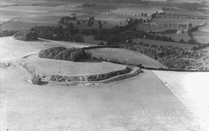
Chanctonbury Ring is a prehistoric hill fort atop Chanctonbury Hill on the South Downs, on the border of the civil parishes of Washington and Wiston in the English county of West Sussex. A ridgeway, now part of the South Downs Way, runs along the hill. It forms part of an ensemble of associated historical features created over a span of more than 2,000 years, including round barrows dating from the Bronze Age to the Saxon periods and dykes dating from the Iron Age and Roman periods.

Savernake Forest stands on a Cretaceous chalk plateau between Marlborough and Great Bedwyn in Wiltshire, England. Its area is approximately 4,500 acres.
Wittenham Clumps are a pair of wooded chalk hills in the Thames Valley, in the civil parish of Little Wittenham, in the historic county of Berkshire, although since 1974 administered as part of South Oxfordshire district.
Founded in 1967, Earth Trust is an environmental charity which was originally known as the Northmoor Trust for Countryside Conservation. Earth Trust was initially established by the British engineer Sir Martin Wood to promote environmental conservation through land management, education, and land science. It is a registered charity under English law.
Long Wittenham is a village and small civil parish about 3 miles (5 km) north of Didcot, and 3.5 miles (5.6 km) southeast of Abingdon. It was part of Berkshire until the 1974 boundary changes transferred it from Berkshire to Oxfordshire, and from the former Wallingford Rural District to the new district of South Oxfordshire.

The Falls of Bruar are a series of waterfalls on the Bruar Water in Scotland, about 8 miles from Pitlochry in the council area of Perth and Kinross. They have been a tourist attraction since the 18th century and were immortalized in a poem by Robert Burns, The Humble Petition of Bruar Water to the Noble Duke of Atholl, supposedly from the river itself entreating the Duke to plant some trees in the then barren landscape.

The woodlands of the Iberian Peninsula are distinct ecosystems on the Iberian Peninsula. Although the various regions are each characterized by distinct vegetation, the borders between these regions are not clearly defined, and there are some similarities across the peninsula.

The Poem Tree was a beech tree with a poem carved into it by Joseph Tubb, located on Castle Hill at Wittenham Clumps in Oxfordshire, England. The tree was believed to be around 300 years old, with Tubb's poem being carved in the 1840s. The tree died in the 1990s and rotted completely while standing, before collapsing during a period of inclement weather in July 2012.

Ashdown Forest, a former royal hunting forest situated some 30 miles south-east of London, is a large area of lowland heathland whose ecological importance has been recognised by its designation as a UK Site of Special Scientific Interest and by the European Union as a Special Protection Area for birds and a Special Area of Conservation for its heathland habitats, and by its membership of Natura 2000, which brings together Europe's most important and threatened wildlife areas.

Tregrug Castle or Llangibby Castle is a ruin in Monmouthshire, Wales, located about 1 mile (1.5 km) to the north of the village of Llangybi, close to the settlement of Tregrug.

Lawthorn is a hamlet near Perceton in Strathannick, Irvine, North Ayrshire, Scotland. The settlement lies on the old Irvine to Stewarton toll road.

The Seven Sisters is a clump of beech trees on Cothelstone Hill in the Quantock Hills, England. Originally planted in the 18th century, they form a well-known and prominent landmark visible from large areas of Somerset and South Wales. The hill is currently leased to the South West Heritage Trust by its owner Somerset County Council, and managed by the Quantock Hills AONB Service under a Higher Level Stewardship Scheme. Three large trees remain from the original planting, while recently planted replacements grow nearby.


