Lancing Ring

Last updated
Lancing Ring
Lancing Ring Footpath - geograph.org.uk - 613991.jpg
Lancing Ring
TypeLocal Nature Reserve
LocationLancing, West Sussex
OS grid TQ 182 062
Area29.4 hectares (73 acres)
Managed byArdur District Council
Website Ardur District Council Lancing Ring webpage

Lancing Ring is a 29.4-hectare (73-acre) Local Nature Reserve in Lancing in West Sussex. It is owned and managed by Adur District Council. [1] [2]

Contents

This chalk grassland site is notable for butterflies, adders, and common lizards. There is also deciduous woodland with wildflowers including early purple orchids and a dew pond, the habitat of dragonflies such as the broad-bodied chaser, Libellula depressa, and numerous newts. [1]

The Dew Pond The Dewpond on Lancing Ring - geograph.org.uk - 1551457.jpg
The Dew Pond
A spacious car park Lancing Ring Car Park - geograph.org.uk - 613985.jpg
A spacious car park

There is access from Mill Road via the main car park and Halewick Lane has an area for parking beside the children's play area at the foot of the hill.

There is a volunteer group that assists Adur District council with conservation management, the Friends of Lancing Ring, formed in 1989.

History

Archaeological research at Lancing Ring has identified it as the likely site of an Iron Age shrine and Romano-Celtic temple. [3] The Romano-Celtic temple site has been identified as the large sloping field above the recycling centre and children's play area at the top of Halewick Lane; [4] this land is now used for agricultural purposes. An Anglo-Saxon burial ground has also been identified to the east of Lancing Ring, towards Hoe Court. [4] Iron Age, Roman and Anglo-Saxon coins have been discovered at Lancing Ring. [3] The track passing through Lancing Ring from Cissbury Ring in the west to the river crossing in Shoreham in the east is likely prehistoric and would once have been an important route for those travelling through the area. [5]

The name Lancing Ring was inspired by the planting of beech trees in a ring layout during the late 18th century, inspired by neighbouring Cissbury Ring. [6] These are likely to have been planted by the Lloyd family after their acquisition of Lancing Manor in an attempt to gentrify the land. [7] The 1987 storm caused extensive damage to many of the original trees. [6]

A disused chalkpit is situated to the west of the car park at the top of Mill Road. Opened around 1805, it was described as a "public chalk pit" for local people to quarry chalk for construction work, building maintenance and for use in manure. [8] It was permanently closed at the beginning of the 20th century following the death of a person collecting chalk from the site. [8] The chalk pit is a geologically important feature as it contains a layer of Tarrant chalk and has yielded important fossil discoveries such as Pelmatopora lancingensis, a Bryozoan (moss animal) of the Cribrilinidae family; and a Crinoid, Bourgueticrinus cf. fritillus. Fossil discoveries from the site are now in the care of the British Museum. [8]

At least one windmill stood at the eastern end of the chalkpit, with the most recent mill to occupy this site having been demolished in 1905. It is uncertain when the first windmill was erected at Lancing Ring, but there is mention of a mill in Lancing in the Domesday Book. [7]

Lancing Ring was used by the Canadian Army during World War II. [7]

In 1949, the land was sold to the local council by the Trustees of Lancing College for use as a permanent public open space for local people. [7] The Friends of Lancing Ring group was established in 1989 with a view to protecting and conserving the land, performing restoration and maintenance work in conjunction with Adur Council and private organisations, and promoting the space to the people of Lancing. [7] The group was instrumental in protesting the development of the A27 road through the area, which would have destroyed the site entirely. [7]

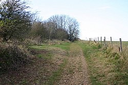
Flora, fauna, and funga

Lancing Ring is host to a great many species. This is helped by the wide range of habitats available within the nature reserve, including woodland, meadowland, pastureland, a dew pond and an old chalk pit.

Notable plants include reed mace, yellow flag iris, purple loosestrife, early purple orchids, wood anemones, arum lilies, spurge laurel and sweet violet. [9] [10] The county flower of Sussex, round-headed rampion, also grows here. [8] Beech trees are abundant although there are also ash, common hawthorn (Crataegus monogyna), blackthorn, elder, wild cherry, sycamore and field maples present. [9] [8] Buddleja can be seen growing in the chalk pit and makes a beautiful display in early summer, attracting pollinating insects. [8] North of the Lancing Manor allotments, McIntyres Field has been designated as a wildflower meadow; [11] this is complemented by other meadowland interspersed throughout the site.

Dragonflies and damselflies can be observed around the dew pond. [10] More rarely, adders and lizards can be spotted, particularly in the chalk pit. [8]

The area is a popular foraging spot among locals. Blackberries are abundant during the late summer months and several species of fungi can be found in the woodland in autumn, such as puffballs, Auricularia auricula-judae ('jelly ear mushrooms'), Macrolepiota procera ('parasol mushrooms') and 'shaggy pholiota' (either Pholiota squarrosa or P. squarrosoides). [9]

Lancing Ring is also a popular spot for birdwatching, with a range of resident and migratory birds frequenting the area. Great spotted woodpeckers, skylarks, redwings and jays have all reportedly been observed, and more common garden birds such as blue tits and robins can also be seen. [9]

Community use

Lancing Ring is a popular site for dog walkers, picnics, birdwatching and foraging. The site also lends itself to landscape photography with stunning panoramic views across Adur Valley and the south coast, from Brighton in the east and towards the Isle of Wight in the west. Friends of Lancing Ring host events such as guided flower walks and volunteer sessions which focus on maintenance and conservation of the reserve. [12]

Lancing Ring is also popular with walkers. From it, an extensive network of paths lead to Steyning, Coombes, Cissbury Ring and the River Adur, as well as further afield.

Related Research Articles

<span class="mw-page-title-main">Shoreham-by-Sea</span> Town in West Sussex, England

Shoreham-by-Sea is a coastal town and port in West Sussex, England.

<span class="mw-page-title-main">Lancing, West Sussex</span> Human settlement in England

Lancing is a large coastal village and civil parish in the Adur district of West Sussex, England, on the western edge of the Adur Valley. It occupies part of the narrow central section of the Sussex coastal plain between smaller Sompting to the west, larger Shoreham-by-Sea to the east, and the parish of Coombes to the north. Excluding definitive suburbs it may have the largest undivided village cluster in Britain. However, its economy is commonly analysed as integral to the Brighton/Worthing/Littlehampton conurbation. Its settled area beneath the South Downs National Park covers 3.65 square miles, the majority of its land.

<span class="mw-page-title-main">South Downs</span> Range of chalk hills in southeast England

The South Downs are a range of chalk hills in the south-eastern coastal counties of England that extends for about 260 sq mi (670 km2) across the south-eastern coastal counties of England from the Itchen valley of Hampshire in the west to Beachy Head, in the Eastbourne Downland Estate, East Sussex, in the east. The Downs are bounded on the northern side by a steep escarpment, from whose crest there are extensive views northwards across the Weald. The South Downs National Park forms a much larger area than the chalk range of the South Downs, and includes large parts of the Weald.

Clay Pit Ponds State Park Preserve is 265-acre (1.07 km2) state park located near the southwestern shore of Staten Island, New York. It is the only state park located on Staten Island.

<span class="mw-page-title-main">Moseley Bog</span>

Moseley Bog and Joy's Wood Local Nature Reserve, formerly The Dell, is a Local Nature Reserve in the Moseley area of Birmingham, England, with an area of about 12 ha. Along with the nearby Sarehole Mill, and a number of other sites, it forms part of the Shire Country Park.

<span class="mw-page-title-main">Cissbury Ring</span> Prehistoric sites near Worthing, West Sussex, England

Cissbury Ring is an 84.2-hectare (208-acre) biological Site of Special Scientific Interest north of Worthing in West Sussex. It is owned by the National Trust and is designated a Scheduled monument for its Neolithic flint mine and Iron Age hillfort.

<span class="mw-page-title-main">Upper Beeding</span> Human settlement in England

Upper Beeding is a village and civil parish in the Horsham District of West Sussex, England. It is located at the northern end of the River Adur gap in the South Downs, four miles (6.4 km) north of Shoreham-by-Sea and has a land area of 1,877 hectares. The site is a bridging point over the river: on the opposite bank are Bramber and Steyning, making the whole area somewhat built-up. The civil parish also includes the smaller village of Small Dole to the north, and the village of Edburton to the northeast.

<span class="mw-page-title-main">Hamsey</span> Village in East Sussex, England

Hamsey is a civil parish in the Lewes District of East Sussex, England. The parish covers a large area and consists of the villages of Hamsey, Offham and Cooksbridge. The main centres of population in the parish are now Offham and Cooksbridge. Around the main settlements are enlarged fields, isolated old cottages and farms. The winding and undulating parish lanes between banks, old hedge rows, trees, flowery verges and ditches are popular with cyclists and give good views of the Downs.

<span class="mw-page-title-main">Queen's Wood</span> 52-acre wood in Haringey, London

Queen's Wood is a 52-acre area of ancient woodland in the London Borough of Haringey, abutting Highgate Wood and lying between East Finchley, Highgate, Muswell Hill and Crouch End. It was originally part of the ancient Forest of Middlesex which covered much of London, Hertfordshire and Essex and was mentioned in the Domesday Book. It is now one of three Local Nature Reserves in the London Borough of Haringey. It is situated a few minutes' walk from Highgate tube station.

<span class="mw-page-title-main">Ditchling Beacon</span> Hill in East Sussex, England

Ditchling Beacon is the highest point in East Sussex, England, with an elevation of 248 m (814 ft). It is south of Ditchling and to the north-east of Brighton. It is a large chalk hill with a particularly steep northern face, covered with open grassland and sheep-grazing areas. It is the third-highest point on the South Downs, behind Butser Hill and Crown Tegleaze.

<span class="mw-page-title-main">Lesnes Abbey Woods</span> Area of ancient woodland in southeast London, England

Lesnes Abbey Woods, sometimes known as Abbey Wood, is a 73 ha ancient woodland in southeast London, England. It is located near to, and named after, the ruined Lesnes Abbey in the London Borough of Bexley and gives its name to the Abbey Wood district. The woods are adjacent to Bostall Woods.

<span class="mw-page-title-main">Lavender Pond</span> Nature reserve in Rotherhithe, London

Lavender Pond is a 2.5 acre local nature reserve in Rotherhithe in the London Borough of Southwark. It is owned by Southwark Council and managed by The Conservation Volunteers. The nature reserve has an area of woodland as well as the pond.

<span class="mw-page-title-main">Harlow Marsh</span>

Harlow Marsh is a 13.8 hectare Local Nature Reserve in Harlow in Essex. It is owned and managed by Harlow District Council.

<span class="mw-page-title-main">Limekiln Close and East Pit</span>

Limekiln Close and East Pit is a 10 hectare Local Nature Reserve (LNR) in Cherry Hinton, on the south-eastern outskirts of Cambridge. It is managed by the Wildlife Trust for Bedfordshire, Cambridgeshire and Northamptonshire as Cherry Hinton Chalk Pits. East Pit is part of the Cherry Hinton Pit biological Site of Special Scientific Interest, which excludes Limekiln Close but includes the neighbouring West Pit.

<span class="mw-page-title-main">Englemere Pond</span>

Englemere Pond is a 26.1-hectare (64-acre) biological Site of Special Scientific Interest on the southern outskirts of North Ascot in Berkshire. The site is also a Local Nature Reserve. It is owned by the Crown Estate and managed by Bracknell Forest Borough Council.

<span class="mw-page-title-main">Mill Hill, Shoreham</span> Nature reserve in West Sussex, England

Mill Hill is a 13.5-hectare (33-acre) Local Nature Reserve on the northern outskirts of Shoreham-by-Sea in West Sussex. It is owned by Adur District Council and managed by the council and the South Downs Joint Committee.

<span class="mw-page-title-main">Watlington and Pyrton Hills</span>

Watlington and Pyrton Hills is a 112.7-hectare (278-acre) biological Site of Special Scientific Interest east of Watlington in Oxfordshire. An area of 1.6 hectares is Watlington Chalk Pit, which is a Local Nature Reserve.

References

  1. 1 2 "Lancing Ring". Local Nature Reserves. Natural England. Retrieved 25 July 2019.
  2. "Map of Lancing Ring". Local Nature Reserves. Natural England. Retrieved 25 July 2019.
  3. 1 2 "Heritage Gateway - Results". www.heritagegateway.org.uk. Retrieved 2022-04-04.
  4. 1 2 "Magic Map Application". magic.defra.gov.uk. Retrieved 2022-04-04.
  5. "Lancing". British History Online | www.british-history.ac.uk. Retrieved 2022-04-04.
  6. 1 2 Trust, Woodland. "Lancing Ring". Woodland Trust. Retrieved 2022-04-04.
  7. 1 2 3 4 5 6 "Lancing Ring". www.glaucus.org.uk. Retrieved 2022-04-04.
  8. 1 2 3 4 5 6 7 FoLR Admin; Sarah Costeloe (2009-03-22). "The Chalk Pit | Reply of 2012 at 7:20 pm". Friends of Lancing Ring. Retrieved 2022-04-04.
  9. 1 2 3 4 "The Woodland". Friends of Lancing Ring. 22 March 2009. Retrieved 2022-04-04.
  10. 1 2 "The Dew Pond". Friends of Lancing Ring. 22 March 2009.
  11. "McIntyres Field". Friends of Lancing Ring. 2009-03-22. Retrieved 2022-04-04.
  12. "Lancing Ring Local Nature Reserve". The Adur & Worthing Wildflower Trail. 2021-01-05. Retrieved 2022-04-04.

50°50′35″N0°19′23″W / 50.843°N 0.323°W / 50.843; -0.323