Brandy Hole Copse

Last updated
Brandy Hole Copse
Bridge at Brandy Hole Copse - geograph.org.uk - 48322.jpg
Brandy Hole Copse
TypeLocal Nature Reserve
LocationChichester, West Sussex
OS grid SU 852 065
Area6.5 hectares (16 acres)
Managed byChichester District Council

Brandy Hole Copse is a 6.5-hectare (16-acre) Local Nature Reserve on the western outskirts of Chichester in West Sussex. It is owned and managed by Chichester District Council. [1] [2] Part of it is a Scheduled Monument, Chichester Dyke. [3]

This site has broadleaved and coniferous woodland, open water, marshland, heath, tall fern and herbs. Fauna includes pipistrelle bats. [1]

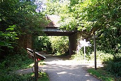
There is access from Brandy Hole Lane and the Centurion Way runs through the site.

Related Research Articles

<span class="mw-page-title-main">Pilsey Island</span>

Pilsey Island is a 17.8-hectare (44-acre) Local Nature Reserve in Chichester Harbour in West Sussex. It is owned by the Ministry of Defence and managed by the Royal Society for the Protection of Birds. It is part of the Chichester Harbour Site of Special Scientific Interest and Nature Conservation Review site, Grade I*, the Chichester and Langstone Harbours Ramsar site and Special Protection Area, and the Solent Maritime Special Area of Conservation.

<span class="mw-page-title-main">Hayling Billy</span>

Hayling Billy is a 42-hectare (100-acre) Local Nature Reserve on Hayling Island in Hampshire. It is owned by Hampshire County Council and managed by Hampshire Countryside Service. It is part of Chichester and Langstone Harbours Ramsar site and Special Protection Area, Solent Maritime Special Area of Conservation and Langstone Harbour Site of Special Scientific Interest.

<span class="mw-page-title-main">Kingley Vale National Nature Reserve</span> Nature reserve in the United Kingdom

Kingley Vale is a 204.4-hectare (505-acre) biological Site of Special Scientific Interest north of Chichester in West Sussex. It is also a Special Area of Conservation and a Nature Conservation Review site, Grade I. An area of 147.9 hectares is a national nature reserve.

<span class="mw-page-title-main">Rowhill Nature Reserve</span>

Rowhill Nature Reserve or Rowhill Copse is a 26.6-hectare (66-acre) Local Nature Reserve (LNR) which straddles the border between Aldershot in Hampshire and Farnham in Surrey. It is owned by Rushmoor Borough Council, was declared an LNR by Waverley Borough Council and is managed by Rowhill Nature Reserve Society.

<span class="mw-page-title-main">Chichester to Silchester Way</span> Roman road in England

The Chichester to Silchester Way is a Roman Road between Chichester in South-East England, which as Noviomagus was capital of the Regni, and Silchester or Calleva Atrebatum, capital of the Atrebates. The road had been entirely lost and forgotten, leaving no Saxon place names as clues to its existence, until its chance discovery through aerial photography in 1949. Only 6 kilometres (3.7 mi) of the 62 kilometres (39 mi) long road remain in use.

<span class="mw-page-title-main">Farley Copse</span> Nature reserve in Bracknell, Berkshire, England

Farley Copse is a 3.3-hectare (8.2-acre) Local Nature Reserve on the western outskirts of Bracknell in Berkshire. It is owned and managed by Bracknell Forest Borough Council.

<span class="mw-page-title-main">Temple Copse</span> Nature reserve in Berkshire, United Kingdom

Temple Copse is a 1.9-hectare (4.7-acre) Local Nature Reserve on the northwestern outskirts of Bracknell in Berkshire. It is owned and managed by Bracknell Forest Borough Council. Along with Jock's Copse and Tinkers Copse it forms part of what is known locally as The Three Copses.

<span class="mw-page-title-main">Tinkers Copse</span>

Tinkers Copse is a 1.9-hectare (4.7-acre) Local Nature Reserve on the northwestern outskirts of Bracknell in Berkshire. It is owned and managed by Bracknell Forest Borough Council. Along with Jock's Copse and Temple Copse it forms part of what is known locally as The Three Copses.

<span class="mw-page-title-main">Holt Copse & Joel Park</span> Local Nature Reserve in Berkshire, England

Holt Copse & Joel Park is a 5.3-hectare (13-acre) Local Nature Reserve (LNR) in Wokingham in Berkshire. It is owned by Wokingham Town Council and managed by the council and Holt Copse Conservation Volunteers.

<span class="mw-page-title-main">Eames Farm</span> Nature reserve in West Sussex

Eames Farm is a 132.5-hectare (327-acre) Local Nature Reserve on Thorney Island in West Sussex. It is owned by the Chichester Harbour Conservancy, West Sussex County Council and the Ministry of Defence and managed by the Chichester Harbour Conservancy. It is part of Chichester and Langstone Harbours Ramsar site and Special Protection Area and Chichester Harbour Site of Special Scientific Interest.

<span class="mw-page-title-main">Nutborne Marshes</span>

Nutborne Marshes is a 386.9-hectare (956-acre) Local Nature Reserve east of Thorney Island in West Sussex. It is owned and managed by Chichester Harbour Conservancy. It is part of the Chichester Harbour Site of Special Scientific Interest and Nature Conservation Review site, Grade I*, the Chichester and Langstone Harbours Ramsar site and Special Protection Area, and the Solent Maritime Special Area of Conservation.

<span class="mw-page-title-main">Martin and Tidpit Downs</span>

Martin and Tidpit Downs is a 367.5-hectare (908-acre) biological Site of Special Scientific Interest north-west of Fordingbridge in Hampshire. Martin Down is a 341-hectare (840-acre) national nature reserve and an area of 115 hectares is a Nature Conservation Review site, Grade I. Bokerley Dyke, a prehistoric linear earthwork and scheduled monument, runs through the site.

<span class="mw-page-title-main">Gutner Point</span>

Gutner Point is a 69-hectare (170-acre) Local Nature Reserve on Hayling Island in Hampshire. It is owned by Hampshire County Council and managed by Hampshire Countryside Service. It is part of Chichester and Langstone Harbours Ramsar site and Special Protection Area, of Solent Maritime Special Area of Conservation, and of Chichester Harbour Site of Special Scientific Interest.

<span class="mw-page-title-main">West Hayling</span>

West Hayling is a 76.2-hectare (188-acre) Local Nature Reserve on Hayling Island in Hampshire. It is owned by Havant Borough Council and managed by the council and the Royal Society for the Protection of Birds. It is part of Langstone Harbour, which is a Site of Special Scientific Interest. It is also part of Solent Maritime Special Area of Conservation and of Chichester and Langstone Harbours Ramsar site and Special Protection Area.

References

  1. 1 2 "Brandy Hole Copse". Local Nature Reserves. Natural England. Retrieved 24 July 2019.
  2. "Map of Brandy Hole Copse". Local Nature Reserves. Natural England. Retrieved 24 July 2019.
  3. Historic England. "Chichester Dyke, Broyle earthwork, section extending 430yds (393m) through East Broyle Copse, to railway, and earthwork extending 400yds (365m) from Brandy Hole Lane, New Fishbourne (1005853)". National Heritage List for England . Retrieved 24 July 2019.

50°51′07″N0°47′28″W / 50.852°N 0.791°W / 50.852; -0.791