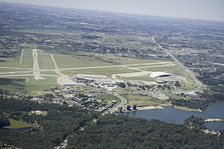
Carrasco/General Cesáreo L. Berisso International Airport is the international airport of Montevideo, the capital city of Uruguay. It also is the country's largest airport and is located in the namegiving Carrasco neighborhood located in the adjoining department of Canelones. It has been cited as one of the most efficient and traveler-friendly airports in Latin America and the world.

Capitán Corbeta C. A. Curbelo International Airport, formerly called Laguna del Sauce International Airport, is an airport serving Punta del Este, Uruguay, located in the adjoining municipality of Maldonado. It is operated by Consorcio Aeropuertos Internacionales S.A. (CAISA). The airport is 14 kilometres (8.7 mi) northwest of Maldonado.

Colonia International Airport is a general aviation airport serving Colonia del Sacramento, capital of the Colonia Department of Uruguay.
Pres. Gral. Óscar D. Gestido International Airport, formerly called Cerro Chapeu International Airport, is an airport serving Rivera, the capital of Rivera Department in Uruguay, and also serving Santana do Livramento, Brazil. The airport is in the countryside 8 kilometres (5 mi) southeast of Rivera.
Nueva Hespérides International Airport is an airport serving Salto, the capital of Salto Department in Uruguay. The airport is 3 kilometres (2 mi) south of the city.

Artigas International Airport is an airport serving Artigas, capital of the Artigas Province of Uruguay. The airport is 2 kilometres (1 mi) west of the city, and is close to the border with Brazil.
Tydeo Larre Borges International Airport is a general aviation airport serving Paysandú, capital of the Paysandú Department of Uruguay. The airport is 3 kilometres (2 mi) south of the city.
Ángel S. Adami Airport is a controlled general aviation airport serving Montevideo, Uruguay, located in the northwestern outskirts of the metropolitan area. The airport and its surrounding area are commonly known as "Aviación" or, due to its location in the neighborhood of Lezica-Melilla, as "Aeródromo de Melilla".

Santa Bernardina International Airport is a military and general aviation airport serving Durazno, capital of the Durazno Department of Uruguay.
Cerro Largo International Airport is an airport serving Melo, capital of the Cerro Largo Department of Uruguay. The airport is in the countryside 5 kilometres (3 mi) northwest of Melo.
Vichadero Airport is an airstrip serving Vichadero, a small town in the Rivera Department of Uruguay. The runway is in the countryside 10 kilometres (6 mi) northeast of the town.
Tacuarembó Airport is an airport serving Tacuarembó, the capital of Tacuarembó Department in Uruguay. The airport is in the countryside 5 kilometres (3 mi) east of the city.

El Jagüel Airport is a general aviation airport serving Maldonado, Uruguay. The airport is in the El Jagüel neighborhood of Punta del Este, 1 mile (1.6 km) east of Maldonado.
Campo Municipal de Aterrizaje Airport is an airport serving the town of Minas in Lavalleja Department, Uruguay.
Villa Independencia Airport is an airport serving the Uruguay River port town of Fray Bentos in the Río Negro Department of Uruguay. The airport is on the south edge of the town.
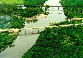
Zagarzazú International Airport is an airport serving the city of Carmelo in Colonia Department, Uruguay. The airport is 4 kilometres (2.5 mi) northwest of Carmelo, by the Río de la Plata village of Zagarzazú. South approach and departure may be over the river.
Placeres Airport is an airport serving the Uruguay River town of Bella Unión in Artigas Department, Uruguay. The airport is in the countryside 7 kilometres (4 mi) south-southeast of Bella Unión. There are 170 metres (560 ft) of unpaved overrun available on the northwest end.
Estancia Presidencial Anchorena Airport is an airport serving Anchorena National Park and the Presidential Estate at Barra de San Juan in Colonia Department, Uruguay. The airport lies along the Río San Juan, 2 kilometres (1 mi) from its confluence into the Río de la Plata estuary.
Cap. Juan Manuel Boiso Lanza Air Base is an air base of the Uruguayan Air Force located in the Montevideo Department of Uruguay. Air Brigade III, which includes the Nº7 Squadron is stationed on the field. The Air Force Command and Staff College is also on the base.