Artigas Airport

Last updated
Artigas International Airport
Aeropuerto Internacional de Artigas
Treminal de Aviones art.jpg
Summary
Airport type Public
Serves Artigas
Elevation  AMSL 125 m / 410 ft
Coordinates 30°24′03″S056°30′28″W / 30.40083°S 56.50778°W / -30.40083; -56.50778 Coordinates: 30°24′03″S056°30′28″W / 30.40083°S 56.50778°W / -30.40083; -56.50778
Map
Uruguay location map.svg
Airplane silhouette.svg
ATI
Location in Uruguay
Runways
Direction Length Surface
m ft
11/29 1,273 4,179 Asphalt
05/23 582 1,911 Grass
Sources: Great Circle Mapper [1]

Artigas International Airport( IATA : ATI, ICAO : SUAG) is the airport serving Artigas, Uruguay.

An IATA airport code, also known as an IATA location identifier, IATA station code or simply a location identifier, is a three-letter code designating many airports around the world, defined by the International Air Transport Association (IATA). The characters prominently displayed on baggage tags attached at airport check-in desks are an example of a way these codes are used.

ICAO airport code four-letter code designating many airports around the world

The ICAOairport code or location indicator is a four-letter code designating aerodromes around the world. These codes, as defined by the International Civil Aviation Organization and published in ICAO Document 7910: Location Indicators, are used by air traffic control and airline operations such as flight planning.

Artigas, Uruguay Capital city in Artigas, Uruguay

Artigas is the capital of the Artigas Department of Uruguay. Its name comes from that of the national hero, José Gervasio Artigas, who fought for the emancipation of the River Plate, and sought to create a federative nation from these colonies. As of the census of 2011, it is the eleventh most populous city of the country.

Contents

History

The airport was opened in November 1973. It is situated close to Uruguay's border with Brazil.

Uruguay republic in South America

Uruguay, officially the Oriental Republic of Uruguay, is a country in the southeastern region of South America. It borders Argentina to its west and Brazil to its north and east, with the Río de la Plata to the south and the Atlantic Ocean to the southeast. Uruguay is home to an estimated 3.44 million people, of whom 1.8 million live in the metropolitan area of its capital and largest city, Montevideo. With an area of approximately 176,000 square kilometres (68,000 sq mi), Uruguay is geographically the second-smallest nation in South America, after Suriname.

Brazil Federal republic in South America

Brazil, officially the Federative Republic of Brazil, is the largest country in both South America and Latin America. At 8.5 million square kilometers and with over 208 million people, Brazil is the world's fifth-largest country by area and the fifth most populous. Brazil borders every South American country except Chile and Ecuador. Its capital is Brasília, and its most populated city is São Paulo. The federation is composed of the union of the 26 states, the Federal District, and the 5,570 municipalities. It is the largest country to have Portuguese as an official language and the only one in the Americas; it is also one of the most multicultural and ethnically diverse nations, due to over a century of mass immigration from around the world.

Airlines and destinations

Currently no scheduled flights operate at this airport.

Accidents and incidents

Carrasco International Airport main airport serving Montevideo, Uruguay

Carrasco/General Cesáreo L. Berisso International Airport is the international airport of Montevideo, the capital city of Uruguay. It also is the country's largest airport and is located in the namegiving Carrasco neighborhood located in the adjoining department of Canelones. It has been cited as one of the most efficient and traveler-friendly airports in Latin America and the world.

Douglas DC-3 airliner and military transport aircraft family

The Douglas DC-3 is a fixed-wing propeller-driven airliner that revolutionized air transport in the 1930s and 1940s. Its lasting effect on the airline industry and World War II makes it one of the most significant transport aircraft ever produced. It has a cruise speed of 207 mph (333 km/h), capacity of 21 to 32 passengers or 6,000 lbs of cargo and a range of 1,500 mi (2,400 km).

Access

The airport is located 3 km (2 mi) from downtown Artigas.


Related Research Articles

Capitán de Corbeta Carlos A. Curbelo International Airport airport serving Punta del Este, Uruguay

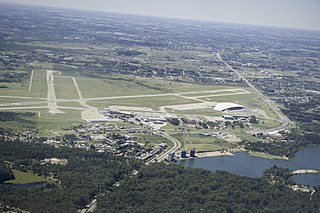
Capitán Corbeta C. A. Curbelo International Airport, formerly called Laguna del Sauce International Airport, is an airport serving Punta del Este, Uruguay, located in the adjoining municipality of Maldonado. It is operated by Consorcio Aeropuertos Internacionales S.A. (CAISA). The airport is 14 kilometres (8.7 mi) northwest of Maldonado.

Punta Gorda Airport (Belize)

Punta Gorda Airport is an airport serving Punta Gorda, a town on Amatique Bay in the Toledo District of southern Belize. The airport is within the town, and less than a kilometer from the bay.

Sarteneja Airport

Sarteneja Airport is an airport serving Sarteneja, a town in the Corozal District in northern Belize. The airport is just east of the town, which is on Chetumal Bay.

Dajabón Airport airport

Dajabón National Airport is an airport that serves Dajabón, the capital of Dajabón Province in the western Dominican Republic. The airport is 4 kilometres (2.5 mi) east of the border with Haiti.

Walterio Field airport in the Dominican Republic

Walterio Airport is a rural airport 10 kilometres (6.2 mi) south of the coastal city of Monte Cristi, Dominican Republic. It serves private aviation and air sports. Now with the Osvaldo Virgil Airport replacing most of its operations, this airport has been reverted as only a runway.

Teniente Coronel Luis A. Mantilla International Airport

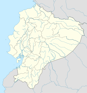
Teniente Coronel Luis A. Mantilla International Airport is a high elevation airport serving Tulcán, capital of the Carchi Province of Ecuador.

Colonia Airport airport

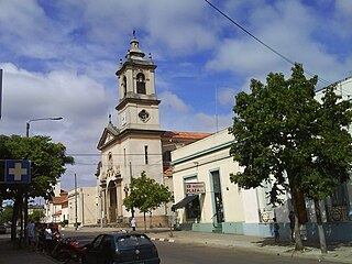
Colonia International Airport is a general aviation airport serving Colonia del Sacramento, capital of the Colonia Department of Uruguay.

Rivera International Airport airport

Pres. Gral. Óscar D. Gestido International Airport, formerly called Cerro Chapeu International Airport, is an airport serving Rivera, the capital of Rivera Department in Uruguay, and also serving Santana do Livramento, Brazil. The airport is in the countryside 8 kilometres (5 mi) southeast of Rivera.

Nueva Hesperides International Airport airport serving Salto, Uruguay

Nueva Hespérides International Airport is an airport serving Salto, the capital of Salto Department in Uruguay. The airport is 3 kilometres (2 mi) south of the city.

Paysandú Airport airport

Tydeo Larre Borges International Airport is a general aviation airport serving Paysandú, capital of the Paysandú Department of Uruguay. The airport is 3 kilometres (2 mi) south of the city.

Ángel S. Adami Airport airport

Ángel S. Adami Airport is a controlled general aviation airport serving Montevideo, Uruguay, located in the northwestern outskirts of the metropolitan area. The airport and its surrounding area are commonly known as "Aviación" or, due to its location in the neighborhood of Lezica-Melilla, as "Aeródromo de Melilla".

Cerro Largo International Airport airport

Cerro Largo International Airport is an airport serving Melo, capital of the Cerro Largo Department of Uruguay. The airport is in the countryside 5 kilometres (3 mi) northwest of Melo.

Vichadero Airport airport

Vichadero Airport is an airstrip serving Vichadero, a small town in the Rivera Department of Uruguay. The runway is in the countryside 10 kilometres (6 mi) northeast of the town.

Treinta y Tres Airport airport

Treinta y Tres Airport is an airport serving Treinta y Tres, capital of the Treinta y Tres Department of Uruguay. The airport is just northeast of the city.

Tacuarembó Airport airport

Tacuarembó Airport is an airport serving Tacuarembó, the capital of Tacuarembó Department in Uruguay. The airport is in the countryside 5 kilometres (3 mi) east of the city.

Útila Airport Airport in Honduras

Útila Airport is an airport serving Útila, Islas de la Bahía, Honduras. It handles regional and international air traffic for the town of Útila. The airport is served by several airlines on a daily schedule, as well as numerous private and charter flights.

Ibra Airport airport in Oman

Ibra is an airport serving Ibra, a town in the Ash Sharqiyah North Governorate of Oman.

Campo Municipal de Aterrizaje Airport

Campo Municipal de Aterrizaje Airport is an airport serving the town of Minas in Lavalleja Department, Uruguay.

Zagarzazú International Airport

Zagarzazú International Airport is an airport serving the city of Carmelo in Colonia Department, Uruguay. The airport is 4 kilometres (2.5 mi) northwest of Carmelo, by the Río de la Plata village of Zagarzazú. South approach and departure may be over the river.

Placeres Airport

Placeres Airport is an airport serving the Uruguay River town of Bella Unión in Artigas Department, Uruguay. The airport is in the countryside 7 kilometres (4 mi) south-southeast of Bella Unión. There are 170 metres (560 ft) of unpaved overrun available on the northwest end.

References

DAFIF or the Digital Aeronautical Flight Information File is a comprehensive database of up-to-date aeronautical data, including information on airports, airways, airspaces, navigation data and other facts relevant to flying in the entire world, managed by the National Geospatial-Intelligence Agency (NGA) of the United States.

National Oceanic and Atmospheric Administration An American scientific agency within the US Department of Commerce that focuses on the oceans and the atmosphere

The National Oceanic and Atmospheric Administration is an American scientific agency within the United States Department of Commerce that focuses on the conditions of the oceans, major waterways, and the atmosphere.

National Weather Service United States weather agency

The National Weather Service (NWS) is an agency of the United States federal government that is tasked with providing weather forecasts, warnings of hazardous weather, and other weather-related products to organizations and the public for the purposes of protection, safety, and general information. It is a part of the National Oceanic and Atmospheric Administration (NOAA) branch of the Department of Commerce, and is headquartered in Silver Spring, Maryland, within the Washington metropolitan area. The agency was known as the United States Weather Bureau from 1890 until it adopted its current name in 1970.