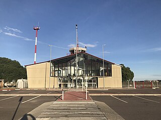
Colonia International Airport is a general aviation airport serving Colonia del Sacramento, capital of the Colonia Department of Uruguay.
Pres. Gral. Óscar D. Gestido International Airport, formerly called Cerro Chapeu International Airport, is an airport serving Rivera, the capital of Rivera Department in Uruguay, and also serving Santana do Livramento, Brazil. The airport is in the countryside 8 kilometres (5 mi) southeast of Rivera.
Artigas International Airport is an airport serving Artigas, capital of the Artigas Province of Uruguay. The airport is 2 kilometres (1 mi) west of the city, and is close to the border with Brazil.
Tydeo Larre Borges International Airport is a general aviation airport serving Paysandú, capital of the Paysandú Department of Uruguay. The airport is 3 kilometres (2 mi) south of the city.

Ángel Adami Airport is a controlled general aviation airport serving Montevideo, Uruguay, located in the northwestern outskirts of the metropolitan area. The airport and its surrounding area are commonly known as "Aviación" or, due to its location in the neighborhood of Lezica-Melilla, as "Aeródromo de Melilla".

Tela Airport is an airport serving Tela, a town in the Atlántida Department on the northern coast of Honduras.
Guápiles Airport is an airport serving Guápiles, a town in Pococí canton, Limón Province, Costa Rica. The runway is within the western section of the town.
Campo de Mayo Airport is a military airport located near San Miguel, Buenos Aires, Argentina.
Tolhuin Lago Fagnano Airport is a public use airport located 2 kilometres (1 mi) northeast of Tolhuin, a lakeside village in the Tierra del Fuego Province of Argentina.
Orange Walk Airport is a public use airport 3 kilometres (2 mi) southwest of Orange Walk Town, Orange Walk District, Belize. The airport was also known as Tower Hill Airport.
Vichadero Airport is an airstrip serving Vichadero, a small town in the Rivera Department of Uruguay. The runway is in the countryside 10 kilometres (6 mi) northeast of the town.

El Jagüel Airport is a general aviation airport serving Maldonado, Uruguay. The airport is in the El Jagüel neighborhood of Punta del Este, 1 mile (1.6 km) east of Maldonado.
Mhlume Airfield is an airstrip serving Mhlume, an agricultural town in the Lubombo Region of Eswatini. The runway is on the northwest corner of the town.
Tshaneni Airfield is an airstrip serving Tshaneni, in Eswatini.
Palcasa Airport is an airport serving the town of El Castillo in Río San Juan Department, Nicaragua. The airport is 5.5 kilometres (3.4 mi) north of El Castillo, midway between the small towns of La Palma and Las Colinas. It is surrounded by and supports the palm oil plantations of Palmares del Castillo S.A. (PALCASA).
Villa Independencia Airport is an airport serving the Uruguay River port town of Fray Bentos in the Río Negro Department of Uruguay. The airport is on the south edge of the town.
Zagarzazú International Airport is an airport serving the city of Carmelo in Colonia Department, Uruguay. The airport is 4 kilometres (2.5 mi) northwest of Carmelo, by the Río de la Plata village of Zagarzazú. South approach and departure may be over the river.
Placeres Airport is an airport serving the Uruguay River town of Bella Unión in Artigas Department, Uruguay. The airport is in the countryside 7 kilometres (4 mi) south-southeast of Bella Unión. There are 170 metres (560 ft) of unpaved overrun available on the northwest end.
Estancia Presidencial Anchorena Airport is an airport serving Anchorena National Park and the Presidential Estate at Barra de San Juan in Colonia Department, Uruguay. The airport lies along the Río San Juan, 2 kilometres (1 mi) from its confluence into the Río de la Plata estuary.
Tulloch Airfield is an airstrip serving the town of Bog Walk in the Saint Catherine Parish of Jamaica.


