Trift Glacier Foreland

Last updated
In the alpine alluvial plain and on the delta on the southern shore of Lake Trift, Alpine willowherb (Epilobium fleischeri) and yellow mountain saxifrage (Saxifraga anizoides), typical pioneer plants of alluvions and moraines, have colonised the area. Alluvial Plain Triftsee 1.jpg
In the alpine alluvial plain and on the delta on the southern shore of Lake Trift, Alpine willowherb (Epilobium fleischeri) and yellow mountain saxifrage (Saxifraga anizoides), typical pioneer plants of alluvions and moraines, have colonised the area.
The retreat of the Trift Glacier since 1864 Triftglacier since 1864.jpg
The retreat of the Trift Glacier since 1864
The Trift river cascades down from the glacier tongue over the rock step to the natural Trift lake. Triftwasser Triftglacier 05.jpg
The Trift river cascades down from the glacier tongue over the rock step to the natural Trift lake.
Protest action against the construction of a dam in the glacier forefield of the Trift Glacier, summer 2019 Protest action Trift 2.jpg
Protest action against the construction of a dam in the glacier forefield of the Trift Glacier, summer 2019

The Trift glacier foreland in the Swiss canton of Bern comprises a wide variety of geomorphological forms and habitats for pioneers and plant communities. At the southern end of Lake Trift, a delta is emerging and an alpine alluvial plain represents a biologically valuable area for a variety of species, some of which are rare and endangered. The Trift basin also harbours potential for generating electricity from a hydroelectric power plant, which is currently being planned.

Contents

Position

The Trift glacier forefield lies in the retreat area of the Trift Glacier in the municipality of Innertkirchen, Canton Bern, between the Susten Pass and the Grimsel Pass. It extends from the glacier break-off (approx. 2300 m above sea level) to the Sunnige Trift (1325 m a. sea level) below the Graaggilamm. The area is drained by the Triftwasser, which flows into the Gadmerwasser. At 1650 metres above sea level lies the Triftsee, which is dammed by a natural narrows. An alpine alluvial plain formed at its southern end, where the Triftwasser branches into several arms and forms the first meanders. [1]

Nature

Diversity of forms in the landscape

According to Mary Leibundgut, who surveyed the area in 2022 using the method developed by the Federal Office for the Environment for the inventory of alluvial zones and updated in 2021, the glacier left behind a variety of different landscape forms. Noticeable features include glacial polish areas, roches moutonnées, drainage channels in the rock and the canyon. In addition to these forms of erosion, forms of accumulation are also present, such as the lateral moraine walls that are still visible in places or the fine-grained ground moraine on the south side of the lake Trift. Outwash plaines, old courses, ponds, river delta, lake and the active, inactive and relict glaciofluvial areas document the dynamics of the Triftwasser and its tributaries. [1]

Geology

The glacier forefield lies entirely in the crystalline rocks of the Aarmassif. In addition to the primary gneisses, a narrow band of volcanic rocks outcrop is also exposed in the area of the SAC hut Trift. Volcanic conglomerates and quartz-rich vulcanites (rhyolite), can therefore also be found in the moraine material of the Trift Glacier. Particularly striking are the huge blocks of amphibolite clods deposited in the glacier foreland, which originate from the Gwächtenhorn area and were transported over long distances by the glacier. The dark amphibolite clods are embedded in a light-coloured, melted granite mass.

The Trift area is characterised by tectonic fault lines, most of which run parallel to the longitudinal extension of the Aarmassif (WSW-ENE) and transverse to the flow direction of the glacier or the valley axis of the Trift river. The dominant landscape element is the striking terrain line that runs from south-west to north-east from the Furtwangsattel over the rocky ridge of Windegg and Drosiegg towards the Steilimmi. It acts like a natural dam, behind which the ice of the Trift glacier has carved out an overdeepened basin and which is cut through by the Triftwasser in a narrow canyon. The natural Trift lake, which has been formed since around 1999, is a typical cirque lake.

Fault lines running at right angles to the valley axis also lead to a special situation in the rock step below today's glacier break-off: under high pressure under the glacier ice, they were carved out to form deep drainage channels that divert the torrent at right angles to the direction of flow. Today, the Triftwasser plunges over the rock step in a 150 m high waterfall, only to disappear into a deep channel and emerge again 200 m further east, flowing down in a series of cascades to the alluvial plain on the southern shore of the lake Trift. [2]

Vegetation

Mary Leibundgut observed a total of 27 different vegetation units in 2022. Predominant are various pioneer communities on silicate rubble, including silicate fine rubble flora, especially on the southern shore of the lake Trift in the hilly ground moraine areas. The Epilobion fleischeri with Fleischer's willowherb is widespread and is one of the habitat types worthy of protection according to the Ordinance on the Protection of Nature and Cultural Heritage. [3] Among the transitional communities are tall grass meadows with Agrostis schraderiana, Calamagrostion. In the lower area of the glacier forefield, the alpine pastures and mixed grasslands, which are grazed by sheep, are partly degenerated and species-poor. Bristlegrass (Nardus stricta) is widespread throughout the foreland, but typically formed Bristlegrass pastures are rare. Large areas in the foreland are occupied by scrub communities, including above all the green alder scrub. The green alder has a long tradition in the area. Thanks to its flexible branches, this pioneer shrub can withstand heavy snow loads and avalanches.

The area from the south bank of the lake towards the Trift Glacier forms an alpine alluvial plain. Thanks to its great dynamism and development potential, it is one of the most valuable areas of the entire glacier foreland. [1]

Fauna

In her aquatic biology report, ecologist Verena Lubini-Ferlin identifies 58 species of aquatic insects in the Triftwasser, Steiwasser and in the alluvial plain at the southern end of Lake Trift. Of these, two species are on the Red List, ten are potentially endangered, seven are national priority species, four are Alpine endemics and five species are considered vulnerable. Water beetles, bugs, caddisflies, stoneflies, mayflies and dragonflies live in the alpine alluvial plain of the glacier forefield of the Trift. Some are characteristic Alpine species such as the water beetle Hydroporus foveolatus and the water bugs (also known as water striders) Arctocarisa carinata and Gerris costae . In addition, three source types revitalise these habitats: Dictyogenus fontium, Consorophylax consors and the two-toothed goldenring ( Cordulegaster bidentata ). There is also evidence of an absolute habitat specialist, the caddisfly Stactobia moselyi, whose larvae live exclusively on trickling rock faces. [4]

Tourism

Alpinists have been interested in this area since the middle of the 19th century. The first Trift hut was built on the spur of the Telltistock in 1864. The first Windegg hut followed in 1891. Both huts were not far from the Trift glacier at the time.

Since the construction of the first pedestrian suspension bridge over the canyon at Trift lake in 2004, the former works railway, which was created with the water catchment in the Sunnigen Trift, has been open to the public. The suspension bridge known as the Triftbrücke was replaced by a new, safer one in 2009. The bridge attracts many tourists. Sport climbers use the climbing routes that have been set up in the area around the Windegghütte in recent years. [1] At around 170 m long and 100 m high, the Trift bridge is one of the largest pedestrian bridges in the Alps. [5]

Power plant project and resistance

Lake Trift was formed naturally when the Trift Glacier melted in the lower Trift basin as a result of global warming. What remained was a naturally dammed lake, the lake Trift, created by the rock barrier at Windegg/Drosiegg. For years, the company based here, Kraftwerke Oberhasli (KWO), a subsidiary of Berner Kraftwerke (BKW), has been planning to dam up around 85 million cubic metres of water with a dam wall over a hundred metres high, which corresponds to an energy content of 215 GWh. According to its own information, the plant could generate 145 GWh of additional electricity per year and store energy. [6]

KWO involved environmental protection organisations in its planning at an early stage, as the reservoir would flood large areas of valuable habitats. The negotiation process led to numerous compromises. In the end, Swiss Alpine Club, World Wide Fund for Nature, Pro Natura and the Bernese Fishing Association approved the Trift reservoir project. [6] The Naturfreunde, [7] Aqua Viva, the Grimselverein, the Triftkomitee [8] and the Klimaspuren campaign report resistance. [9] In June 2023 the Bernese cantonal parliament gave the KWO the green light to build the project. Environmental organisations remain divided, with some continuing to oppose the construction of a dam on Lake Trift. [10] On 27 December 2023, Aqua Viva and the Grimsel Association lodged an appeal with the Bern Administrative Court against the granting of the licence by the Grand Council of the Canton of Bern. [11]

See also

Related Research Articles

<span class="mw-page-title-main">Geology of the Alps</span> The formation and structure of the European Alps

The Alps form part of a Cenozoic orogenic belt of mountain chains, called the Alpide belt, that stretches through southern Europe and Asia from the Atlantic all the way to the Himalayas. This belt of mountain chains was formed during the Alpine orogeny. A gap in these mountain chains in central Europe separates the Alps from the Carpathians to the east. Orogeny took place continuously and tectonic subsidence has produced the gaps in between.

<span class="mw-page-title-main">Feldberg (Black Forest)</span> Mountain in the Black Forest, Baden-Württemberg, Germany

At 1,493 metres (4,898 ft) the Feldberg in the Black Forest is the highest mountain in Baden-Württemberg, and the highest in Germany outside of the Alps and Bavaria. The local municipality of Feldberg was named after the mountain.

<span class="mw-page-title-main">Aletsch Glacier</span> Largest glacier in the Alps

The Aletsch Glacier or Great Aletsch Glacier is the largest glacier in the Alps. It has a length of about 23 km (14 mi) (2014), a volume of 15.4 km3 (3.7 cu mi) (2011), and covers about 81.7 km2 (2011) in the eastern Bernese Alps in the Swiss canton of Valais. The Aletsch Glacier is composed of four smaller glaciers converging at Konkordiaplatz, where its thickness was measured by the ETH to be still near 1 km (3,300 ft). It then continues towards the Rhône valley before giving birth to the Massa. The Aletsch Glacier is – like most glaciers in the world today – a retreating glacier. As of 2016, since 1980 it lost 1.3 kilometres (0.81 mi) of its length, since 1870 3.2 kilometres (2.0 mi), and lost also more than 300 metres (980 ft) of its thickness.

Landforms are categorized by characteristic physical attributes such as their creating process, shape, elevation, slope, orientation, rock exposure, and soil type.

<span class="mw-page-title-main">Wisconsin glaciation</span> North American glacial ice sheet

The Wisconsin Glacial Episode, also called the Wisconsin glaciation, was the most recent glacial period of the North American ice sheet complex. This advance included the Cordilleran Ice Sheet, which nucleated in the northern North American Cordillera; the Innuitian ice sheet, which extended across the Canadian Arctic Archipelago; the Greenland ice sheet; and the massive Laurentide Ice Sheet, which covered the high latitudes of central and eastern North America. This advance was synchronous with global glaciation during the last glacial period, including the North American alpine glacier advance, known as the Pinedale glaciation. The Wisconsin glaciation extended from approximately 75,000 to 11,000 years ago, between the Sangamonian Stage and the current interglacial, the Holocene. The maximum ice extent occurred approximately 25,000–21,000 years ago during the last glacial maximum, also known as the Late Wisconsin in North America.

<span class="mw-page-title-main">Merced River</span> River in California

The Merced River, in the central part of the U.S. state of California, is a 145-mile (233 km)-long tributary of the San Joaquin River flowing from the Sierra Nevada into the San Joaquin Valley. It is most well known for its swift and steep course through the southern part of Yosemite National Park, where it is the primary watercourse flowing through Yosemite Valley. The river's character changes dramatically once it reaches the plains of the agricultural San Joaquin Valley, where it becomes a slow-moving meandering stream.

<span class="mw-page-title-main">Glacial landform</span> Landform created by the action of glaciers

Glacial landforms are landforms created by the action of glaciers. Most of today's glacial landforms were created by the movement of large ice sheets during the Quaternary glaciations. Some areas, like Fennoscandia and the southern Andes, have extensive occurrences of glacial landforms; other areas, such as the Sahara, display rare and very old fossil glacial landforms.

<span class="mw-page-title-main">Glacial lake</span> Lake formed by a melted glacier

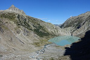
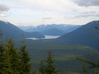
A glacial lake is a body of water with origins from glacier activity. They are formed when a glacier erodes the land and then melts, filling the depression created by the glacier.

<span class="mw-page-title-main">Riss glaciation</span>

The Riss glaciation, Riss Glaciation, Riss ice age, Riss Ice Age, Riss glacial or Riss Glacial is the second youngest glaciation of the Pleistocene epoch in the traditional, quadripartite glacial classification of the Alps. The literature variously dates it to between about 300,000 to 130,000 years ago and 347,000 to 128,000 years ago. It coincides with the Saale glaciation of North Germany. The name goes back to Albrecht Penck and Eduard Brückner who named this cold period after the river Riss in Upper Swabia in their three-volume work Die Alpen im Eiszeitalter published between 1901 and 1909.

<span class="mw-page-title-main">Swiss Plateau</span> Plateau in the European Alps

The Swiss Plateau or Central Plateau is one of the three major landscapes in Switzerland, lying between the Jura Mountains and the Swiss Alps. It covers about 30% of the Swiss surface area, and is partly flat but mostly hilly. The average height is between 400 metres (1,300 ft) and 700 metres (2,300 ft) AMSL. It is by far the most densely populated region of Switzerland, the center of economy and important transportation.

<span class="mw-page-title-main">Terminal moraine</span> Type of moraine that forms at the terminal of a glacier

A terminal moraine, also called an end moraine, is a type of moraine that forms at the terminal (edge) of a glacier, marking its maximum advance. At this point, debris that has accumulated by plucking and abrasion, has been pushed by the front edge of the ice, is driven no further and instead is deposited in an unsorted pile of sediment. Because the glacier acts very much like a conveyor belt, the longer it stays in one place, the greater the amount of material that will be deposited. The moraine is left as the marking point of the terminal extent of the ice.

<span class="mw-page-title-main">Oberhasli</span> Talschaft in Switzerland

The Oberhasli is a historical Landvogtei or Talschaft in the Bernese Highlands, Switzerland, bordering on the cantons of Obwalden (OW), Nidwalden (NW), Uri (UR) and Wallis (VS).

<span class="mw-page-title-main">Chester Morse Lake</span>

Chester Morse Lake is a lake in the upper region of the Cedar River watershed in the U.S. state of Washington. The original lake surface was 1,530 feet above sea level, but when the river was dammed in 1900, the elevation was raised to 1,560 feet. Chester Morse Lake is more than four miles (6 km) long, and is primarily fed from the east by the north and south forks of the Cedar River, and from the south by the Rex River. The lake is part of the Seattle area water supply.

<span class="mw-page-title-main">Uri Alps</span> Mountain range in central Switzerland

The Uri Alps are a mountain range in Central Switzerland and part of the Western Alps. They extend into the cantons of Obwalden, Valais, Bern, Uri and Nidwalden and are bordered by the Bernese Alps and the Emmental Alps to the west, the Schwyzer Alps to the north, the Lepontine Alps to the south and the Glarus Alps to the east (Reuss).

<span class="mw-page-title-main">Swiss Alpine Club</span> Mountaineering club

The Swiss Alpine Club is the largest mountaineering club in Switzerland. It was founded in 1863 in Olten and it is now composed of 111 sections with 160,000 members (2020). These include the Association of British Members of the Swiss Alpine Club.

<span class="mw-page-title-main">Trift Bridge</span> Footbridge in the Swiss Alps

The Trift Bridge is a pedestrian-only suspension bridge in the Swiss Alps. The bridge is a simple suspension bridge design spanning 170 metres (560 ft) at a height of 100 metres (330 ft).

The glacial series refers to a particular sequence of landforms in Central Europe that were formed during the Pleistocene glaciation beneath the ice sheets, along their margins and on their forelands during each glacial advance.

<span class="mw-page-title-main">Munich gravel plain</span> Pleistocene Outwash plain in Bavaria, Germany

The Munich gravel plain is an outwash plain in Upper Bavaria, Germany, formed during Late Pleistocene glacial periods. Characterized by its very wide extension, it comprises sandur terraces and the floodplain of the Isar river. These most recent deposits overlie the Neogene Molasse basin of the Alpine Foreland, which in contrast comprises fine-grained fluviatile and lacustrine facies.

<span class="mw-page-title-main">Kiser Lake Wetlands State Nature Preserve</span>

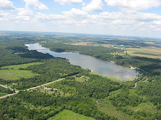
Kiser Lake Wetlands State Nature Preserve, or simply Kiser Lake Wetlands, is a 51 acres (21 ha) nature reserve located in Johnson Township, Champaign County, Ohio, United States. It is located wholly within the Kiser Lake State Park, and operated by the Ohio Department of Natural Resources.

References

  1. 1 2 3 4 Leibundgut, Mary (2022). "Gletschervorfeld Trift. IGLES mapping 2022" [Trift Glacier Foreland. IGLES mapping 2022](PDF). Rettet die Trift (in German). Triftkomittee. Retrieved 2023-12-28.
  2. Abrecht, Jürgen (2022). "Geologie und Morphologie des Triftgebiets (Kurzfassung)" [Geology and Morphology in the Trift Area (short version)](PDF) (in German). Retrieved 2023-12-30.
  3. "Ordinance on the Protection of Nature and Cultural Heritage". Fedlex - The Publication Platform of Federal Law. Swiss Confederation. 2017-06-01.
  4. Lubini-Ferlin, Verena (2023). "Gewässerbiologisches Gutachten Trift- und Steiwasser" [Water biology report on Trift river and Stei river](PDF) (in German). In collaboration with Remo Wüthrich and Emil Birnstiel (published 2023-12-18). Retrieved 2023-12-30.
  5. "Triftbrücke - spektakuläre Fussgängerbrücke". my Switzerland. Schweiz Tourismus. Retrieved 2023-11-07.
  6. 1 2 Sarah Steinmann (2023-05-25). "Triftstaumauer: Wasserkraft in Partnerschaft mit der Natur" (in German). BKW. Retrieved 2023-11-02.
  7. "Rettet die Trift" (in German). Naturfreunde Schweiz. 2020-10-02. Retrieved 2023-11-02.
  8. "Rettet die Trift" (in German). Triftkomitee. 2022. Retrieved 1 December 2023.
  9. Aschwanden, Erich (2021-07-03). "Der Kampf um das Triftgebiet. Wenn Gletscher zu Stauseen werden sollen" [The battle for the Trift area. When glaciers are to become reservoirs]. Neue Zürcher Zeitung (in German). Retrieved 2023-12-03.
  10. "Bern winkt Trift-Staumauer durch - Umweltverbände kämpfen weiter" (in Swiss German). SRF: Schweiz aktuell. 2023-06-09. Retrieved 2023-11-03.
  11. "Trift: Beschwerde für den Erhalt eines Naturjuwels" [Trift: Complaint for the preservation of a natural jewel]. Aqua viva (in German). 2023-12-29. Retrieved 2023-12-30.

46°41′40″N8°21′27″E / 46.69444°N 8.35750°E / 46.69444; 8.35750