
Mumbai Suburban district is the second most populous district of Maharashtra in the Konkan Division. With its administrative headquarters in Bandra, the district consists of three subdivisions or tehsils (townships): Kurla, Andheri, and Borivali. The district along with Mumbai City district and other suburban localities make up Greater Mumbai. The district occupies an area of 446 km2.

Nashik district, also known as Nasik district, is a district in Maharashtra, India. The city of Nashik is the administrative headquarters of the district. Nashik is well known for the production of wine. Nashik is also known as Mini Maharashtra, because the climate and soil conditions of Surgana, Peth, Igatpuri resembles with Konkan. Niphad, Sinnar, Dindori, Baglan blocks are like Western Maharashtra and Yeola, Nandgaon, Chandwad blocks are like Vidarbha Region. Nashik is the biggest city in the district while Malegaon is the second biggest city. Manmad, Igatpuri, and Sinnar are some of the big cities situated in the Nashik District. Manmad is one of the biggest railway junctions in India while the city of Malegaon is famous for its powerloom.

Bathinda district is in Malwa region of Punjab, India. The district encompasses an area of 3,385 square kilometers. By area, Bathinda district is the second-largest in Punjab, after Ludhiana district. It is bounded by Faridkot district and Moga district on the north, Muktsar district on the west, Barnala and Mansa districts on the east, and the state of Haryana on the south. Bathinda is cotton producing belt of Punjab.
Solapur South Taluka is one of the 11 tehsils of Solapur District in the Indian state of Maharashtra. This tehsil is located in the southeastern side of district and is bordered by Osmanabad District to the northeast, North Solapur and Mohol Taluka to the north, Akkalkot Taluka to the southeast, Karnataka's Kalaburagi district to the south, and Mangalvedhe Taluka to the west. The tehsil headquarters is located at Solapur, which is also the district headquarters and its largest city. Mandrup, Kumbhari, Valasang, Musti and Boramani are the biggest villages in south Solapur.

Akole taluka is a taluka in Ahmednagar district in Maharashtra state of India. Akole consists of many places like Harishchandragad, Kalsubai, Bhandardara (Wilson) Dam, Sandhan Valley, Vishramgad etc. which attract tourists. Akole is not only famous for its natural scenery but, many historical events are also associated with it. The Western Akole is a part of Sahyadri ranges which increase its important.

Rahata taluka, is a taluka in Shrirampur subdivision of Ahmednagar district in Maharashtra State of India.
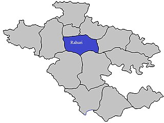
Rahuri taluka, is a taluka in the Shrirampur subdivision of the Ahmednagar district in Maharashtra, western India.

Shrirampur taluka, is a taluka in Shrirampur subdivision of Ahmednagar district in Maharashtra state of India.
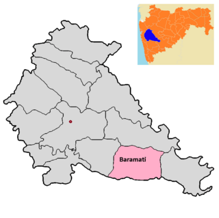
Baramati taluka is a taluka in Baramati subdivision of Pune district of state of Maharashtra in India.

Bhor taluka is a taluka in Haveli subdivision of Pune district of state of Maharashtra in India. There are 195 villages and 1 town in Bhor Taluka.

Taluka Haveli is a subdivision of the district of Pune, Maharashtra. The Pune Municipal Corporation & Pimpri Chinchwad Municipal Corporation, Pune are at the center of & entirely surrounded by the taluka for administrative purposes. The region of Pune Metropolitan Region has claimed the major part of the same.

Indapur taluka is a taluka in Baramati subdivision of Pune district of state of Maharashtra in India.

Khed taluka is a taluka in the subdivision, near Pune city in Pune district of the state of Maharashtra in India. Rajgurunagar is the headquarter of the taluka. The taluka is known for being the birthplace of Santaji Jagnade.The name of city is rajgurunagar on the name of Shaheed Shivram Hari Rajguru.

Purandar taluka is a taluka of Pune district of state of Maharashtra in India. There are 108 villages and 3 towns in Purandhar Taluka.

Shirur taluka, is a taluka in Haveli subdivision of Pune district of state of Maharashtra in India. The town is situated on the bank of river Ghod and hence it was also known as Ghodnadi in 20th Century. The town is on the border of Pune & Ahmed Nagar District and hence, main trading center for Shirur Taluka as well as Parner Taluka located in Ahmed Nagar District.
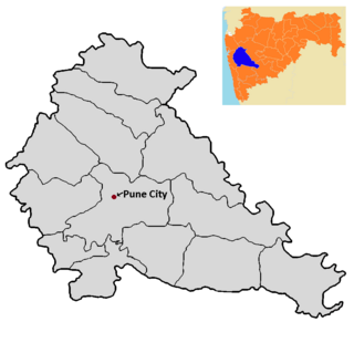
Pune City taluka is the main taluka in the Pune district of state of Maharashtra in India.

Barshi Taluka is one of the 11 talukas of Solapur District in the Indian state of Maharashtra. This tehsil occupies the Northeast corner of the district and is bordered by Osmanabad District to the north and east, Madha Taluka to the west, Mohol Taluka to the southwest and North Solapur Taluka to the south. The tehsil headquarters is located at Barshi, which is also the largest city in the tehsil.

Velhe Taluka, is a taluka in Haveli subdivision of Pune district of state of Maharashtra in India. The Taluka is entirely rural, and consists of 130 villages.

Karmala Taluka is one of the 11 talukas of Solapur district in the Indian state of Maharashtra. Parts of the movie Sairat were shot in this taluka. Its headquarters are in the town of Karmala.

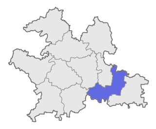
Sarangarh-Bilaigarh district is one of the four new district in the state of Chhattisgarh, India announced by Bhupesh Baghel on 15th August 2021. It is carved out from Raigarh and Baloda Bazar districts.
