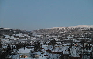
Meråker is a municipality in Trøndelag county, Norway. It is part of the Stjørdalen region. The administrative centre of the municipality is the village of Midtbygda which is about 20 kilometres (12 mi) west of Storlien in Sweden and 46 kilometres (29 mi) east of the town of Stjørdalshalsen in neighboring Stjørdal municipality. Other villages in Meråker include Gudåa, Kopperå, and Stordalen.

Snåsa (Norwegian) or Snåase (Southern Sami) is a municipality in Trøndelag county, Norway. It is part of the Innherred region. The administrative centre of the municipality is the village of Snåsa. Other villages include Agle and Jørstad.

Namsskogan is a municipality in Trøndelag, Norway. Namsskogan is located in the upper part of the long Namdalen valley region. The administrative centre of the municipality is the village of Namsskogan. Other villages in the municipality include Brekkvasselv, Smalåsen, Skorovatn, and Trones.

Verdalsøra is a town in the municipality of Verdal in Trøndelag county, Norway. The town is the administrative center of the municipality. It is located along the Trondheimsfjord at the mouth of the river Verdalselva. The village of Vinne lies 4 kilometres (2.5 mi) to the southeast, Trones lies about 5 kilometres (3.1 mi) to the north, the villages of Forbregd/Lein lie about 4 kilometres (2.5 mi) to the northeast, and the village of Stiklestad lies about 3 kilometres (1.9 mi) to the east. In 1998, the municipal council of Verdal voted to grant the urban area of Verdalsøra town status under the laws of Norway.

Stiklestad is a village and parish in the municipality of Verdal in Trøndelag county, Norway. It is located 4 kilometres (2.5 mi) east of the town of Verdalsøra and about 2 kilometres (1.2 mi) southeast of the village of Forbregd/Lein. The village is mainly known as the site of the Battle of Stiklestad on 29 July 1030. Stiklestad Church is located in the village and it is assumed to have been erected on the exact spot where King Olaf II Haraldsson fell in the battle. The king was buried in Nidaros (Trondheim), canonised there on 3 August 1031, and later enshrined in Nidaros Cathedral. Following the Lutheran reformation of 1537 the saint's remains were removed and their precise resting-place has been unknown since 1568.

Vuku is a village in the municipality of Verdal in Trøndelag county, Norway. It is located at the confluence of the rivers Helgåa and Inna where they become the Verdalselva river. The village is about 40 kilometres (25 mi) west of the village of Vera and about 15 kilometres (9.3 mi) east of the town of Verdalsøra. Vuku is also a parish covering the central part of Verdal municipality, with Vuku Church located in this village.
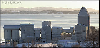
Hylla is a village in the municipality of Inderøy in Trøndelag county, Norway. Hylla is located along the Trondheimsfjord, about 2 kilometres (1.2 mi) south of the village of Røra and about 8 kilometres (5.0 mi) east of the villages of Straumen and Sakshaug. The village is home to a large limestone quarry and processing facility.
Skogmo is a village in the municipality of Overhalla in Trøndelag county, Norway. It is located along the Norwegian County Road 17, about 4 kilometres (2.5 mi) northeast of the municipal centre, Ranemsletta. The village lies just north of the river Namsen and about 5 kilometres (3.1 mi) southwest of the lake Eidsvatnet.
Breivika or Breidvik is a village in the municipality of Inderøy in Trøndelag county, Norway. It is located along the Trondheimsfjord in the northern part of the Inderøya peninsula, about 1.5 kilometres (0.93 mi) northwest of the village of Gangstadhaugen.
Forbregd and Lein are two small adjoining villages in the municipality of Verdal in Trøndelag county, Norway. Statistics Norway classifies the urban area as Forbregd/Lein. The village area is located about 4 kilometres (2.5 mi) northeast of the town of Verdalsøra and about 2 kilometres (1.2 mi) northwest of Stiklestad, along the southern shore of the lake Leksdalsvatnet. The 0.43-square-kilometre (110-acre) village has a population (2018) of 849 and a population density of 1,974 inhabitants per square kilometre (5,110/sq mi).
Støren (help·info) is the administrative centre of Midtre Gauldal municipality in Trøndelag county, Norway. The village is located in the Gauldalen valley at the confluence of the rivers Gaula and Sokna. Støren is located on the European route E06 highway, about 50 kilometres (31 mi) south of the city of Trondheim. The junction between the Dovrebanen and Rørosbanen railway lines is at Støren Station in the northern part of the village. Støren Church, a school, government services, and commercial and industrial sites are all located in the village.

Sparbu is a village in the municipality of Steinkjer in Trøndelag county, Norway. The village is located about 12 kilometres (7.5 mi) south of the town of Steinkjer. The European route E6 highway runs through the village as does the Nordlandsbanen railway line which stops at the Sparbu Station. The village of Mære lies about 2 kilometres (1.2 mi) to the north, the village of Røra lies about 8 kilometres (5.0 mi) to the south, and the lake Leksdalsvatnet lies about 8 kilometres (5.0 mi) to the east.
Spillum is a village in the municipality of Namsos in Trøndelag county, Norway. The village is located along the south side of the Namsen river about 5 kilometres (3.1 mi) directly south of the centre of the town of Namsos and about 4 kilometres (2.5 mi) north of the village of Klinga. The Norwegian Sawmill Museum is located in the village of Spillum.
Vera is a village in the municipality of Verdal in Trøndelag county, Norway. It is located on the northern shore of the lake Veresvatnet, about 4 kilometres (2.5 mi) west of the border with Sweden, about 2 kilometres (1.2 mi) south of the edge of Blåfjella–Skjækerfjella National Park, and about 40 kilometres (25 mi) east of the village of Vuku. Vera is also a parish covering the eastern part of Verdal municipality, with Vera Chapel located in this village.

Vinne is a village in the municipality of Verdal in Trøndelag county, Norway. It is located just south of the Verdalselva river, about 4 kilometres (2.5 mi) southeast of the town of Verdalsøra and about the same distance to the west of the village of Lysthaugen. Vinne is also a parish covering the southern part of western Verdal municipality, with Vinne Church located in this village. The Bergsgrav Station is a train stop in Vinne along the Nordlandsbanen railway line.
Lysthaugen is a village in the municipality of Verdal in Trøndelag county, Norway. It is located on the southern side of the river Verdalselva, about 10 kilometres (6.2 mi) east of the town of Verdalsøra and about 7 kilometres (4.3 mi) southwest of the village of Vuku. The mountain Skitholvola lies about 8 kilometres (5.0 mi) south of the village.
Trones is a village in the municipality of Namsskogan in Trøndelag county, Norway. It is located along the river Namsen about 30 kilometres (19 mi) south of the village of Namsskogan and about 15 kilometres (9.3 mi) south of the village of Brekkvasselv. The village of Skorovatn is located about 30 kilometres (19 mi) to the southeast. Trones Church is located in Trones, and it is the main church for the area. European route E6 highway and the Nordlandsbanen railway line both pass through the village.
Namsskogan is the administrative centre of Namsskogan municipality in Trøndelag county, Norway. The village is located in the Namdalen valley on an island in the middle of the river Namsen, although it also includes land on both sides of the river. The European route E06 highway and the Nordlandsbanen railway line both run through the village, with the train stopping at Namsskogan Station. The village of Brekkvasselv lies about 12 kilometres (7.5 mi) to the south. Bjørhusdal Church is located about 4 kilometres (2.5 mi) west of the village.
The movie "Edge of Darkness 1943" was made about the valour of citizens of Trones against Nazis with the help of secret British weapon supplies. A great movie.


