Tropical Evergreen forests of India

Last updated
Map all coordinates using: OpenStreetMap  
Download coordinates as: KML
Indian Forest cover map as of 2015 Indian Forest Cover.png
Indian Forest cover map as of 2015

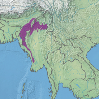
Tropical Evergreen forests of India are found in the Andaman and Nicobar Islands, [upper-alpha 1] as Western Ghats, [upper-alpha 2] which fringe the Arabian Sea, the coastline of peninsular India, and the greater Assam region in the north-east. [upper-alpha 3] Small remnants of evergreen forest are found in Odisha state. [upper-alpha 4] Semi-evergreen forest is more extensive than the evergreen formation partly because evergreen forests tend to degrade to semi-evergreen with human interference. There are substantial differences between the three major evergreen forest regions. [1]

Contents

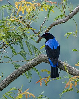
The Western Ghats monsoon forests occur both on the western (ghats) margins of the coastal and on the eastern side where there is less rainfall. These forests contain several tree species of great commercial significance (e.g. Indian rosewood (Dalbergia latifolia), Malabar Kino (Pterocarpus marsupium), teak (Tectona grandis) and Indian laurel (Terminalia crenulata)), but they have now been cleared from many areas. In the evergreen forests, there is an enormous number of tree species; at least 60 percent of the trees of the upper canopy are of species which individually contribute not more than one percent of the total number. Clumps of bamboo occur along streams or in poorly drained hollows throughout the evergreen and semi-evergreen forests of south-west India, probably in areas once cleared for transporting agriculture.

The tropical vegetation of north-east India (which includes the states of Assam, Nagaland, Manipur, Mizoram, Tripura and Meghalaya as well as the plain regions of Arunachal Pradesh) typically occurs at elevations up to 900 metres (3,000 ft). It embraces evergreen and semi-evergreen forests, moist deciduous monsoon forests, riparian forests, swamps and grasslands. Evergreen forests are found in the Assam Valley, the foothills of the eastern Himalayas and the lower parts of the Naga Hills, Meghalaya, Mizoram and Manipur, where the rain fall exceeds 2,300 mm (91 in) per annum. In the Assam Valley the giant Hollong (Dipterocarpus macrocarpus) and Shorea assamica occur singly, occasionally attaining a girth of up to 7 metres (23 ft) and a height of up to 50 metres (160 ft). The monsoon forests are mainly moist sal (Shorea robusta) forests, which occur widely in this region. [2]

The Andaman and Nicobar islands have tropical evergreen forests and tropical semi-evergreen forests as well as tropical monsoon forests. [3] The dominant species of Keruing wood is Dipterocarpus grandiflorus in hilly areas, while Dipterocarpus kerrii is dominant on some islands in the southern parts of the archipelago. The monsoon forests of the Andamans are dominated by the Andaman Redwood (Pterocarpus dalbergioides) and Terminalia spp . [4] [ better source needed ]

Tropical forests in India's east present a total contrast with the pine and coniferous woodland of the Western Himalayas. The natural cover of India varies with altitude; these evergreen forests are bounded with high alpine meadows nearer to the snowline and temperate forests of short stout trees at lower elevations. In the Himalayan foothills are deciduous trees, with shrubs, bamboo, ferns and grass.

India's northern plains, the course of the holy rivers Ganges and Yamuna; the Thar Desert in the west; the Sundarbans, the marshy swamplands, in the delta of the Ganges and the Brahmaputra, in the east; the Deccan Plateau, lying in the rain shadow of the hills and the Western Ghats with their dense; luxuriant forests – all provide fascinating variations in habitats. These forests sustain 350 species of mammals, 2,100[ citation needed ] kinds of birds (both local and migratory), nearly 350 species of reptile and countless insects. Conservation preserves the ecological diversity and our life support systems-water, air and soil. It helps reserve the genetic diversity of plants and animals for better growth of species. The need for conservation of the environment and the forests has exercised the minds of Indian rulers from the earliest of times. In recent times, it was the administrators and princely rulers who demarcated and reserved forests as private preserves. Today many of the forested regions form the nucleus of India's wildlife sanctuaries and parks. Still, increasing population, hunting and encroachments continues to threaten India's forest lands. [5] [ better source needed ]

See also

Notes

  1. Andaman and Nicobar Islands coordinates: 11°41′N92°46′E / 11.68°N 92.77°E
  2. Western Ghats coordinates: 10°10′01″N77°04′01″E / 10.167°N 77.067°E
  3. Assam coordinates: 26°08′N91°46′E / 26.14°N 91.77°E
  4. Odisha coordinates: 20°09′N85°30′E / 20.15°N 85.50°E

Related Research Articles

Geography of India Geography of the country of India

India is situated north of the equator between 8°4' north to 37°6' north latitude and 68°7' east to 97°25' east longitude. It is the seventh-largest country in the world, with a total area of 3,287,263 square kilometres (1,269,219 sq mi). India measures 3,214 km (1,997 mi) from north to south and 2,933 km (1,822 mi) from east to west. It has a land frontier of 15,200 km (9,445 mi) and a coastline of 7,516.6 km (4,671 mi).

Tropical and subtropical moist broadleaf forests Habitat type defined by the World Wide Fund for Nature

Tropical and subtropical moist forest (TSMF), also known as tropical moist forest, is a tropical and subtropical forest habitat type defined by the World Wide Fund for Nature. The habitat type is sometimes known as jungle.

Asian fairy-bluebird Species of bird

The Asian fairy-bluebird is a medium-sized, arboreal passerine bird.

Malabar Coast moist forests

The Malabar Coast moist forests is a tropical moist broadleaf forest ecoregion of southwestern India.

South Western Ghats moist deciduous forests

The South Western Ghats moist deciduous forests is a tropical moist broadleaf forest ecoregion of southern India. It covers the southern portion of the Western Ghats range and the Nilgiri Hills between 250 and 1000 meters elevation in Kerala, Karnataka and Tamil Nadu states.

South Deccan Plateau dry deciduous forests

The South Deccan Plateau dry deciduous forests is a tropical dry forest ecoregion in southern India. The ecoregion lies in the southernmost portion of the Deccan Plateau, and includes the southernmost portion of the Eastern Ghats.

Nicobar Islands rain forests

The Nicobar Islands rain forests is a tropical moist broadleaf forest ecoregion in the Nicobar Islands. The Nicobar Islands are in the Indian Ocean, lying north of Sumatra and south of the Andaman Islands. The islands are politically part of India, although physically closer to Southeast Asia. Millions of years of isolation from the mainland has given rise to a distinct flora and fauna, including many endemic species.

An evergreen forest is a forest made up of evergreen trees. They occur across a wide range of climatic zones, and include trees such as coniferous and holly in cold climates, eucalyptus, Live oak, acacias and banksia in more temperate zones, and rainforest trees in tropical zones.

Narcondam Island

Narcondam, India's easternmost Island, is a small volcanic island located in the northern Andaman Sea. The island's peak rises to 710 m above mean sea level, and it is formed of andesite. It is part of the Andaman Islands, the main body of which lie approximately 74 km (46 mi) to the west.The island is part of the Indian union territory of Andaman and Nicobar Islands. The island is small, covering an area of approximately 6.8 square kilometres. It was classified as a dormant volcano by the Geological Survey of India.

Sri Venkateswara National Park National park in Andhra Pradesh, India

Sri Venkateswara National Park is a national park and biosphere reserve in Andhra Pradesh, India. The total area of the park is 353 km2. The park is known for its many waterfalls, including the Talakona, Gundalakona and Gunjana. As the government of India declared the Seshachalam Hills as one of the biosphere reserves of India in 2010, this national park becomes the part of it.

Eastern Highlands moist deciduous forests

The Eastern Highlands moist deciduous forests, or East Deccan moist deciduous forests, is a tropical and subtropical moist broadleaf forests ecoregion in east-central India. The ecoregion covers an area of 341,100 square kilometers (131,700 sq mi), extending across portions of Andhra Pradesh, Chhattisgarh, Jharkhand, Madhya Pradesh, Maharashtra, Odisha, and Telangana states.

Mount Harriet National Park Indian national park

Mount Harriet National Park is a national park located in the Andaman and Nicobar Islands union territory of India. The park, established in 1969, covers about 4.62 km2 (18.00 mi2). Mount Harriet, which is part of the park, is the third-highest peak in the Andaman and Nicobar archipelago next to Saddle Peak in North Andaman and Mount Thullier in Great Nicobar.

Lower Gangetic Plains moist deciduous forests

The Lower Gangetic Plains moist deciduous forests is a tropical and subtropical moist broadleaf forests ecoregion of Bangladesh and India. The ecoregion covers an area of 254,100 square kilometres (98,100 sq mi), comprising most of Bangladesh and the Indian states of West Bengal, Bihar and Tripura, and extending into adjacent states of Odisha, Uttar Pradesh and a tiny part of Assam.

Brahmaputra Valley semi-evergreen forests

The Brahmaputra Valley semi-evergreen forests is a tropical moist broadleaf forest ecoregion of Northeastern India and southern Bhutan.

<i>Dipterocarpus gracilis</i> Species of tree

Dipterocarpus gracilis is a critically endangered species of tree in the family Dipterocarpaceae, native to South Asia and Southeast Asia.

Mizoram–Manipur–Kachin rain forests

The Mizoram-Manipur-Kachin rain forests is a subtropical moist broadleaf forest ecoregion which occupies the lower hillsides of the mountainous border region joining India, Bangladesh, and Burma (Myanmar). The ecoregion covers an area of 135,600 square kilometres (52,400 sq mi). Located where the biotas of the Indian Subcontinent and Indochina meet, and in the transition between subtropical and tropical regions of Asia, the Mizoram-Manipur-Kachin rain forests are home to great biodiversity. The WWF rates the ecoregion as "Globally Outstanding" in biological distinctiveness.

Sri Lanka lowland rain forests Ecoregion in Sri Lanka

The Sri Lanka lowland rain forests represents Sri Lanka's Tropical rainforests below 1,000 m (3,281 ft) in elevation in the southwestern part of the island. The year-around warm, wet climate together with thousands years of isolation from mainland India have resulted in the evolution of numerous plants and animal species that can only be found in rain forests in Sri Lanka. The thick forest canopy is made up of over 150 species of trees, some of the emergent layer reaching as high as 45 m (148 ft). The lowland rain forests accounts for 2.14 percent of Sri Lanka's land area. This ecoregion is the home of the jungle shrew, a small endemic mammal of Sri Lanka. Sri Lanka has the highest density of amphibian species worldwide. Many of these, including 250 species of tree frogs, live in these rain forests.

Dehing Patkai National Park

Dehing Patkai National Park is located in the Dibrugarh and Tinsukia districts of Assam and covers an area of 231.65 km2 (89.44 sq mi) rainforest. It was declared a wildlife sanctuary on 13 June 2004. On 13 December 2020 Government of Assam upgraded it into a national park. On 9 June 2021 Forest Department of Assam officially notified it as a national park. It is located in the Dehing patkai landscape which is a dipterocarp-dominated lowland rainforest. The rainforest stretches for more than 575 km2 (222 sq mi) in the districts of Dibrugarh, Tinsukia and Charaideo. The forest further spreads over in the Tirap and Changlang districts of Arunachal Pradesh. The Dehing Patkai forms the largest stretch of lowland rainforests in India. The Dehing Patkai Wildlife Sanctuary was declared as Dehing-Patkai Elephant Reserve under Project Elephant.

Biogeographic classification of India Wikipedia article on biogeography of India

Biogeographic classification of India is the division of India according to biogeographic characteristics. Biogeography is the study of the distribution of species (biology), organisms, and ecosystems in geographic space and through geological time. India has a rich heritage of natural diversity. India ranks fourth in Asia and tenth in the world amongst the top 17 mega-diverse countries in the world. India harbours nearly 11% of the world’s floral diversity comprising over 17500 documented flowering plants, 6200 endemic species, 7500 medicinal plants and 246 globally threatened species in only 2.4% of world’s land area. India is also home to four biodiversity hotspots—Andaman & Nicobar Islands, Eastern Himalaya, Indo-Burma region, and the Western Ghats. Hence the importance of biogeographical study of India's natural heritage.

<i>Actephila excelsa</i> Species of plant in the Phyllanthaceae family

Actephila excelsa is a species of shrub in the family Phyllanthaceae. It is native to an area in Tropical Asia and Zhōngguó/China, from Sulawesi to India and Guangxi. It is a highly variable species and leaf forms vary across adjacent ecozones. The plant is used in building houses and as a vegetable. Grey-shanked douc langurs eat the leaves.

References

  1. (IUCN, 1986 Rodges and Panwar, 1988)
  2. (IUCN, 1991)
  3. (IUCN, 1986)
  4. "Forest in India,Tropical Forest in India,Rain Forest India,Indian Forests". Wild-india.com. Retrieved 2010-08-31.
  5. "Indian Rainforest,India Rainforests,Rainforest Travel,Rain Forest,Rainforests in India". Indianwildlifeportal.com. Retrieved 2010-08-31.