Kolonia Bogoria is a village in the administrative district of Gmina Bogoria, within Staszów County, Świętokrzyskie Voivodeship, in south-central Poland. It lies approximately 4 kilometres (2 mi) south-west of Bogoria, 9 km (6 mi) north-east of Staszów, and 52 km (32 mi) south-east of the regional capital Kielce.
Kolonia Pęcławice is a village in the administrative district of Gmina Bogoria, within Staszów County, Świętokrzyskie Voivodeship, in south-central Poland. It lies approximately 3 kilometres (2 mi) east of Bogoria, 13 km (8 mi) north-east of Staszów, and 55 km (34 mi) south-east of the regional capital Kielce.
Kolonia Wysoki Małe is a village in the administrative district of Gmina Bogoria, within Staszów County, Świętokrzyskie Voivodeship, in south-central Poland. It lies approximately 4 kilometres (2 mi) north-east of Bogoria, 15 km (9 mi) north-east of Staszów, and 54 km (34 mi) south-east of the regional capital Kielce.
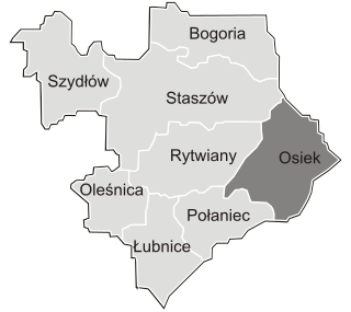
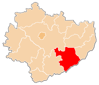
Kąty is a village in the administrative district of Gmina Osiek, within Staszów County, Świętokrzyskie Voivodeship, in south-central Poland. It lies approximately 3 kilometres (2 mi) south-east of Osiek, 23 km (14 mi) east of Staszów, and 74 km (46 mi) south-east of the regional capital Kielce.
Łęg is a village in the administrative district of Gmina Osiek, within Staszów County, Świętokrzyskie Voivodeship, in south-central Poland. It lies approximately 4 kilometres (2 mi) south of Osiek, 21 km (13 mi) east of Staszów, and 73 km (45 mi) south-east of the regional capital Kielce.
Lipnik is a village in the administrative district of Gmina Osiek, within Staszów County, Świętokrzyskie Voivodeship, in south-central Poland. It lies approximately 4 kilometres (2 mi) south-east of Osiek, 23 km (14 mi) east of Staszów, and 75 km (47 mi) south-east of the regional capital Kielce.
Matiaszów is a village in the administrative district of Gmina Osiek, within Staszów County, Świętokrzyskie Voivodeship, in south-central Poland. It lies approximately 7 kilometres (4 mi) south of Osiek, 21 km (13 mi) south-east of Staszów, and 74 km (46 mi) south-east of the regional capital Kielce.
Mucharzew is a village in the administrative district of Gmina Osiek, within Staszów County, Świętokrzyskie Voivodeship, in south-central Poland. It lies approximately 7 kilometres (4 mi) west of Osiek, 15 km (9 mi) south-east of Staszów, and 67 km (42 mi) south-east of the regional capital Kielce.
Niekrasów is a village in the administrative district of Gmina Osiek, within Staszów County, Świętokrzyskie Voivodeship, in south-central Poland. It lies approximately 6 kilometres (4 mi) south-west of Osiek, 18 km (11 mi) south-east of Staszów, and 70 km (43 mi) south-east of the regional capital Kielce.
Niekurza is a village in the administrative district of Gmina Osiek, within Staszów County, Świętokrzyskie Voivodeship, in south-central Poland. It lies approximately 10 kilometres (6 mi) south-west of Osiek, 21 km (13 mi) south-east of Staszów, and 74 km (46 mi) south-east of the regional capital Kielce.
Ossala is a village in the administrative district of Gmina Osiek, within Staszów County, Świętokrzyskie Voivodeship, in south-central Poland. It lies approximately 7 kilometres (4 mi) south-west of Osiek, 17 km (11 mi) south-east of Staszów, and 69 km (43 mi) south-east of the regional capital Kielce.
Ossala-Lesisko is a village in the administrative district of Gmina Osiek, within Staszów County, Świętokrzyskie Voivodeship, in south-central Poland. It lies approximately 9 kilometres (6 mi) west of Osiek, 14 km (9 mi) south-east of Staszów, and 67 km (42 mi) south-east of the regional capital Kielce.
Pliskowola is a village in the administrative district of Gmina Osiek, within Staszów County, Świętokrzyskie Voivodeship, in south-central Poland. It lies approximately 4 kilometres (2 mi) west of Osiek, 17 km (11 mi) east of Staszów, and 69 km (43 mi) south-east of the regional capital Kielce.
Strużki is a village in the administrative district of Gmina Osiek, within Staszów County, Świętokrzyskie Voivodeship, in south-central Poland. It lies approximately 8 kilometres (5 mi) south-west of Osiek, 17 km (11 mi) south-east of Staszów, and 70 km (43 mi) south-east of the regional capital Kielce.
Suchowola is a village in the administrative district of Gmina Osiek, within Staszów County, Świętokrzyskie Voivodeship, in south-central Poland. It lies approximately 4 kilometres (2 mi) north-west of Osiek, 18 km (11 mi) east of Staszów, and 68 km (42 mi) south-east of the regional capital Kielce.
Sworoń is a village in the administrative district of Gmina Osiek, within Staszów County, Świętokrzyskie Voivodeship, in south-central Poland. It lies approximately 5 kilometres (3 mi) south of Osiek, 21 km (13 mi) south-east of Staszów, and 73 km (45 mi) south-east of the regional capital Kielce.
Szwagrów is a village in the administrative district of Gmina Osiek, within Staszów County, Świętokrzyskie Voivodeship, in south-central Poland. It lies approximately 8 kilometres (5 mi) south of Osiek, 21 km (13 mi) south-east of Staszów, and 73 km (45 mi) south-east of the regional capital Kielce.
Trzcianka is a village in the administrative district of Gmina Osiek, within Staszów County, Świętokrzyskie Voivodeship, in south-central Poland. It lies approximately 5 kilometres (3 mi) south-west of Osiek, 20 km (12 mi) south-east of Staszów, and 72 km (45 mi) south-east of the regional capital Kielce.
Tursko Wielkie is a village in the administrative district of Gmina Osiek, within Staszów County, Świętokrzyskie Voivodeship, in south-central Poland. It lies approximately 9 kilometres (6 mi) south-west of Osiek, 19 km (12 mi) south-east of Staszów, and 72 km (45 mi) south-east of the regional capital Kielce.
Tursko Małe-Kolonia is a colony in the administrative district of Gmina Połaniec, within Staszów County, Świętokrzyskie Voivodeship, in south-central Poland. It lies approximately 6 kilometres (4 mi) east of Połaniec, 19 km (12 mi) south-east of Staszów, and 72 km (45 mi) south-east of the regional capital Kielce.