
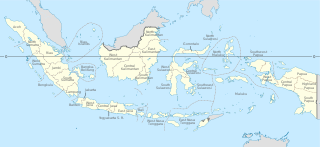
Papua is a province of Indonesia, comprising the northern coast of Western New Guinea together with island groups in Cenderawasih Bay to the west. It roughly follows the borders of Papuan customary region of Tabi Saireri. It is bordered by nation of Papua New Guinea to the east, the Pacific Ocean to the north, Cenderawasih Bay to the west, and the provinces of Central Papua and Highland Papua to the south. The province also shares maritime boundaries with Palau in the Pacific. Following the splitting off of twenty regencies to create the three new provinces of Central Papua, Highland Papua, and South Papua on 30 June 2022, the residual province is divided into eight regencies and one city (kota), the latter being the provincial capital of Jayapura. The province has a large potential in natural resources, such as gold, nickel, petroleum, etc. Papua, along with five other Papuan provinces, has a higher degree of autonomy level compared to other Indonesian provinces.
Provinces are the first-level administrative divisions of Indonesia. It is formerly called the first-level provincial region before the Reform era. Provinces have a local government, consisting of a governor and a regional legislative body. The governor and members of local representative bodies are elected by popular vote for five-year terms, but governors can only serve for two terms. Provincial governments have the authority to regulate and manage their own government affairs, subject to the limits of the central government. The average land area of all 38 provinces in Indonesia is about 49,800 km2 (19,200 sq mi), and they had an average population in mid 2023 of 7,334,111 people.

The Maoke Mountains is a mountain range in the province of Central Papua and Highland Papua. It extends over 692 km and is composed of the Sudirman and Jayawijaya ranges. It is part of the larger New Guinea Highlands or Central Cordillera.

West Papua, formerly Irian Jaya Barat, is an Indonesian province located in Indonesia Papua. It covers most of the two western peninsulas of the island of New Guinea: the eastern half of the Bird's Head Peninsula and the whole of the Bomberai Peninsula, along with nearby smaller islands. The province is bordered to the north by the Pacific Ocean, to the west by Southwest Papua Province, the Halmahera Sea and the Ceram Sea, to the south by the Banda Sea, and to the east by the province of Central Papua and the Cenderawasih Bay. Manokwari is the province's capital and largest city. With an estimated population of 569,570 in mid-2023, West Papua is the least populous province in Indonesia after South Papua, following the separation off in 2022 of the western half of the Bird's Head Peninsula to create the new province of Southwest Papua, containing 52% of what had been West Papua's population. Its population density is similar to Russia.

Puncak Trikora is a 4,730 or 4,750-metre-high (15,584 ft) mountain in the Highland Papua province of Indonesia on New Guinea. It lies in the eastern part of the Sudirman (Nassau) Range of the Maoke Mountains.

Sorong is the largest city and the capital of the Indonesian province of Southwest Papua. The city is located on the western tip of the island of New Guinea with its only land borders being with Sorong Regency. It is the gateway to Indonesia's Raja Ampat Islands, species rich coral reef islands in an area considered the heart of the world's coral reef biodiversity. It also is the logistics hub for Indonesia's thriving eastern oil and gas frontier. Sorong experienced rapid growth during the decade from 2010, and further growth is anticipated as Sorong becomes linked by road to other frontier towns in Papua's Bird's Head Peninsula. The official estimate of population as at mid 2023 was 294,978 - comprising 154,543 males and 140,435 females. The suburban area of Sorong city contains tropical rainforest and mangrove forest that has increasingly become popular as ecotourism attractions especially for birdwatching or wildlife watching.

Frans Kaisiepo was a Papuan politician and Indonesian nationalist. He served as the fourth Governor of Papua Province. In 1993, Kaisiepo was posthumously declared a National Hero of Indonesia for his lifelong efforts to unite West Irian with Indonesia. As the representative of Papua province, he was involved in the Malino Conference, where the formation of the United States of Indonesia was discussed.

Puncak Jaya Regency is one of the regencies (kabupaten) in the Indonesian province of Central Papua. It is an inland highland regency, lying directly east of Paniai Regency and west of Jayawijaya Regency and Tolikara Regency. As of 2004, it was reported that these four regencies had a population that is 93–97% ethnic Papua; however this included areas which have subsequently been formed into new regencies.
Ilaga is the name of a small town and a farming valley in Central Papua, Indonesia, with an elevation of 2,286 m (7,500 ft). It is also the capital of a government district (kecamatan) of the same name, and of the newly created (2008) Puncak Regency. Most of the residents of the area belong to the Lani tribe. It has a small airport and a tiny community of non-Papuan traders and government officials from other parts of Indonesia. A river of the same name runs through the valley, and is a tributary of the Ilorong. The valley lies about midway between the Enarotali and Baliem valleys.

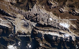
Tembagapura is a district in Mimika Regency, part of the Indonesian province of Central Papua, centered on an urban village built to support the Grasberg Mine. The district covers 2,586.86 km2, and it had a population of 16,917 at the 2010 Census and 23,022 at the 2020 Census.

Puncak Jaya or Carstensz Pyramid on the island of New Guinea, with an elevation of 4,884 m (16,024 ft), is the highest mountain peak of an island on Earth, and the highest peak in Indonesia. The mountain is located in the Sudirman Range of the highlands of Mimika Regency, Central Papua, Indonesia. Puncak Jaya is ranked 5th in the world by topographic isolation.
The West Northwall Firn was a glacial body on Mount Carstensz in the Sudirman Range on the island of New Guinea in Central Papua province, Indonesia. The glacier was situated at an elevation of approximately 4,600 metres (15,100 ft) to 4,750 metres (15,580 ft), centered a little over 3 kilometres (1.9 mi) northwest of Ngga Pulu and 5 kilometres (3.1 mi) of Puncak Jaya, the highest peak of Oceania.
The East Northwall Firn was a glacier on Mount Carstensz in the Sudirman Range on the island of New Guinea in Central Papua province, Indonesia. Situated at an elevation of approximately 4,750 metres (15,580 ft) 2.5 kilometres (1.6 mi) NNW of Puncak Jaya, the highest summit in Oceania. It broke up in three patches in or before 2017.
The Carstensz Glacier is near the peak of Puncak Jaya which is a mountain in the Sudirman Range of the island of New Guinea, territorially the eastern highlands of Central Papua, Indonesia. The glacier is situated at an elevation of approximately 4,660 metres (15,290 ft) and is 1.5 kilometres (0.93 mi) east of the summit tower of Puncak Jaya. In 2002 the Carstensz Glacier was 1.4 kilometres (0.87 mi) in length and .60 kilometres (0.37 mi) wide. In November 2023 it was only 470 metres (1,540 ft) length and 100 metres (330 ft) wide.

Lake Sentani is a tropical, shallow, and at low-altitude open lake located at the northeast extremity of the Jayapura Regency in the Indonesian province of Papua, about 20 kilometres (12 mi) from the provincial capital, Jayapura City. It is located just to the south of the town of Sentani.

Busiri Suryowinoto was an Indonesian military officer and politician who served as the Indonesian ambassador to Papua New Guinea from 1977 until 1980, and as the governor of Irian Jaya from 1981 until 1982.

Central Papua, officially the Central Papua Province is an Indonesian province located in the central region of Western New Guinea. It was formally established on 11 November 2022 from the former eight western regencies of the province of Papua. It covers an area of 61,072.91 km2 and had an officially estimated population of 1,452,810 in mid 2023. It is bordered by the Indonesian provinces of West Papua to the west, the province of Papua to the north and northeast, by Highland Papua to the east, and by South Papua to the southeast. The administrative capital is located in Wanggar District in Nabire Regency, although Timika is a larger town.

Highland Papua is a province of Indonesia, which roughly follows the borders of Papuan customary region of Lano-Pago, shortened to La Pago. It covers an area of 51,213.33 km2 (19,773.58 sq mi) and had a population of 1,448,360 according to the official estimates as at mid 2023.

Southwest Papua is the 38th province of Indonesia to be created, and was split off from West Papua on 8 December 2022. Despite being named southwest, it is a misnomer and this province is actually located in the northwest edge of Papua. The province comprises the Greater Sorong area which consists of Sorong City, Sorong Regency, South Sorong Regency, Maybrat Regency, Tambrauw Regency, and Raja Ampat Regency. The Bill (RUU) on the Establishment of the Southwest Papua Province was passed into law and therefore it became the 38th province in Indonesia with effect from 8 December 2022.

Nduga is an indigenous tribe in the Central Highlands region of southern Papua, particularly in the Nduga Regency and surrounding areas. The territory of the Nduga people borders the Dani and Lani to the north, the Asmat to the south, the Damal to the west, and the Ngalik to the east.

