Tubuai tropical moist forests

Last updated
Tubuai tropical moist forests
Tubuai depuis le mont Taita'a.jpg
View of Tubuai from Mount Taita'a
Austral isl Maria.PNG
Map of the Austral Islands
Ecology
Realm Oceanian
Biome tropical and subtropical moist broadleaf forests
Geography
Area142 km2 (55 sq mi)
Country French Polynesia
Administrative subdivisions Austral Islands
Conservation
Conservation status Critical/endangered [1]
Protected0 km² (0%) [2]

The Tubuai tropical moist forests is a tropical and subtropical moist broadleaf forests ecoregion in French Polynesia. It covers the Austral Islands.

Contents

Geography

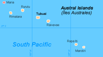
The Austral islands include two island groups, the Tubuai Group and the Bass Islands. The Tubuai Group (22–23º S, 147–152º W) includes the four inhabited islands of Rimatara, Rurutu, Tubuai, and Raivavae, along with the uninhabited Îles Maria atoll. The Bass Islands (27º 35' S, 144º W) include inhabited Rapa island (or Rapa Iti) and the uninhabited Marotiri or Bass Rocks to the southeast. Tubuai is the largest of the Austral islands at 44 km2. The total land area of the ecoregion is 142 km2. [1] [3]

The islands are volcanic in origin, formed as the Pacific Plate moved west-northwest over a geologic hotspot. [1] The inhabited islands have volcanic rocks at the center of the island, with rings of coralline limestone, known as makatea, in the coastal lowlands. Makatea was created when the islands were uplifted to expose ancient coral reefs, and often forms rough and uncultivable terrain.

Tubuai has two central peaks which rise above 400 meters, and are surrounded and separated by makatea at lower elevations. Rurutu Island has volcanic hills at the center of the island, with Manureva reaching 385 meters elevation. The island was geologically uplifted, creating a continuous makatea rim along the shore that reaches 50 to 60 meters high. Rimatara Island also has a makatea rim, with low and weathered central volcanic hills. Maria is a low coral atoll. Raivavae is an heavily eroded extinct volcano with a central peak (Hiro, 438 meters), with makatea outcrops along the shore, and surrounded by a lagoon and encircling barrier reef.

Rapa is an ancient crescent-shaped volcanic caldera. Its highest point is Perau at 633 meters, which is also the highest peak in the ecoregion. Marotiri consists of very young, steep volcanic crags with no fringing reef.

Flora

The natural vegetation includes lowland forest and montane rain forests.

There are about 185 native species of flowering plants in the Tubuai group, of which 28, or 15%, are endemic. [3] 20% of Rimatara's plants are endemic. [1] Rapa has 189 vascular plant species, of which 67, or 35%, are endemic. [3] Rapa's forests also include typical Oceanian genera like Metrosideros, Fitchia, Bidens , and Sclerotheca , as well as genera with New Zealand affinities like Hebe, Olearia, Haloragis , and Corokia . [1]

Montane forests on Tubuai include the trees Metrosideros collina, Aleurites moluccanus, Celastrus vitiensis, Myrsine spp., Ixora spp., Psychotria spp., Cantium barbatum , and Charpentiera australis , along with the tree fern Sphaeropteris medullaris and the large fern Angiopteris . [1]

Endemic flora

Plants endemic to Rapa Iti include the flowering plants Meryta choristantha, Corokia colleneettei, Astelia rapensis, Apostates rapae, Bidens meyeri, Fitchia rapensis, Oparanthus coriaceus, Oparanthus intermedius, Oparanthus rapensis, Sclerotheca margaretae, Gymnosporia pertinax, Pterophylla rapensis, Carex rapaensis, Cyperus rapaensis, Leptecophylla rapae, Vaccinium rapae, Acalypha rapensis, Claoxylon collenettei, Sophora rapaensis Trichomanes calyculatum, Trichomanes truncatum, Angiopteris rapensis, Ceodes coronata, Ceodes rapaensis, Pandanus rapensis, Glochidion longfieldiae, Glochidion rapaense, Pittosporum luteum, Pittosporum maireaui, Pittosporum perahuense, Pittosporum purpureum, Pittosporum rapense, Pittosporum takauele, Callitriche insularis, Plantago rapensis, Plantago rupicola, Veronica rapensis, Lysimachia rapensis, Myrsine rapensis, Coprosma cookei , Coprosma rapensis var. rapensis, Ixora stokesii, Kadua rapensis, Psychotria rapensis, Melicope balgooyi, Exocarpos psilotiformis , Santalum insulare var. margaretae, Allophylus rapensis, Myoporum rapense, Metatrophis margaretae, Pilea australis , and Pilea occulta . [4]

Ferns endemic to Rapa Iti include Asplenium quaylei var. rapense, Athyrium tenuipaleatum, Cyathea stokesii, Diplazium fosbergii, Diplazium rapense, Thelypteris diversisora, Thelypteris margaretae, Thelypteris stokesii, Ctenitis rapensis, Adiantum glabrum, Elaphoglossum meyeri, Elaphoglossum rapense , Lepisorus mucronatus var. durus, Polystichum rapense , and Polystichum stokesii .

Acalypha raivavensis, Sophora raivavaeensis, Pittosporum raivavaeense , Pteris tripartita var. raivavensis, Ixora raivavaensis, Psychotria raivavaensis , Santalum insulare var. raivavense, Myoporum stokesii, Pilea sykesii , and Procris pedunculata var. stokesii are endemic to Raivavae.

Cyrtandra elizabethae is endemic to Rurutu.

Bidens saint-johniana is endemic to Marotiri.

Myoporum rimatarense is endemic to Rimatara.

Macaranga raivavaeensis is native to Raivavae and Rimatara. Serianthes rurutensis is endemic to Rurutu and Raivavae. Glochidion raivavense is endemic to Raivavae, Rurutu, and Tubuai. Polystichum australium is endemic to Raivavae and Tubuai.

Fauna

The ecoregion has two endemic birds. The Rimatara reed warbler (Acrocephalus rimatarae) is limited to Rimatara, but is locally abundant. The Rapa fruit-dove (Ptilonopus huttoni), is found only in 3 km2 of mid- to high-elevation forest fragments on Rapa. [1]

Kuhl's lorikeet (Vini kuhli) once ranged across the Cook Islands and French Polynesia, but is now found only Rimatara, and on three islands in Kiribati where it was introduced by humans. The introduced Brown rat (Rattus norvegicus) preys on the bird's eggs and chicks. [1]

Conservation and threats

The lowland forests on the main high islands have mostly been destroyed by conversion to agriculture, anthropogenic fires, and uncontrolled grazing by introduced goats, pigs, cattle, and horses. Outside cultivated areas, secondary vegetation includes thickets of Hibiscus tiliaceus with introduced orange trees and common guava (Psidium guajava), Dicranopteris linearis fernlands, and grasslands. The lowland atoll forests of the uninhabited Maria Islands are relatively intact. [1]

Montane forests have also been reduced and degraded, but some relatively inaccessible or uncultivable areas remain intact. [1]

Many exotic plants are naturalized, and some are considered invasive. On Tubuai Falcataria falcata, Furcraea foetida, Hedychium flavescens, Lantana camara, Leucaena leucocephala, Melia azedarach, Merremia peltata, Psidium guajava , and Syzygium cumini are naturalized, and Melinis minutiflora, Paspalum conjugatum, Psidium cattleianum, Rubus rosifolius, Stachytarpheta urticifolia, Syzygium jambos , and Tecoma stans are considered invasive. Psidium cattleianum or Chinese guava covers many mountain ridges on Tubuai, the former habitat of Charpentiera australis and other native species. On Rapa Hedychium flavescens and Melia azedarach are considered invasive. [3]

Brown rats (Rattus norvegicus) were introduced to some of the islands by humans, and have decimated some of the local birds, including Kuhl's lorikeet. Rat control is important to the lorikeet's conservation on Rimatara. [1]

Related Research Articles

<span class="mw-page-title-main">Tubuai</span> Island in French Polynesia

Tubuai, Tubuaʻi or Tupuaʻi is the main island of the Austral Island group, located 640 km (400 mi) south of Tahiti. In addition to Tubuai, the group of islands include Rimatara, Rurutu, Raivavae, Rapa and the uninhabited Îles Maria. They are part of the Austral Islands in the far southwest of French Polynesia in the south Pacific Ocean. Tubuai island sustains a population of 2,217 people on 45 km2 of land. Due to its southerly position, Tubuai has notably cooler weather than Tahiti.

<span class="mw-page-title-main">Flag of French Polynesia</span> Flag of the French overseas country of French Polynesia

The flag of French Polynesia is the civil and state flag of the French overseas country French Polynesia. It was adopted in 1984. According to the articles of adoption, the flag of French Polynesia must be displayed with the French tricolor, and may be displayed with the flags of the component archipelagos. The French Polynesian flag must be displayed to the left of the French flag, and the flag of the archipelago must be displayed to its right.

<span class="mw-page-title-main">Austral Islands</span> Archipelago in French Polynesia

The Austral Islands are the southernmost group of islands in French Polynesia, an overseas country of the French Republic in the South Pacific. Geographically, they consist of two separate archipelagos, namely in the northwest the Tupua'i islands consisting of the Îles Maria, Rimatara, Rūrutu, Tupua'i Island proper and Ra'ivāvae, and in the southeast the Bass Islands composed of the main island of Rapa Iti and the small Marotiri. Inhabitants of the islands are known for their pandanus fiber weaving skills. The islands of Maria and Marotiri are not suitable for sustained habitation. Several of the islands have uninhabited islets or rocks off their coastlines. Austral Islands' population is 6,965 on almost 150 km2 (58 sq mi). The capital of the Austral Islands administrative subdivision is Tupua'i.

<span class="mw-page-title-main">Hawaiian tropical rainforests</span>

The Hawaiian tropical rainforests are a tropical moist broadleaf forest ecoregion in the Hawaiian Islands. They cover an area of 6,700 km2 (2,600 sq mi) in the windward lowlands and montane regions of the islands. Coastal mesic forests are found at elevations from sea level to 300 m (980 ft). Mixed mesic forests occur at elevations of 750 to 1,250 m, while wet forests are found from 1,250 to 1,700 m. Moist bogs and shrublands exist on montane plateaus and depressions. For the 28 million years of existence of the Hawaiian Islands, they have been isolated from the rest of the world by vast stretches of the Pacific Ocean, and this isolation has resulted in the evolution of an incredible diversity of endemic species, including fungi, mosses, snails, birds, and other wildlife. In the lush, moist forests high in the mountains, trees are draped with vines, orchids, ferns, and mosses. This ecoregion includes one of the world's wettest places, the slopes of Mount Waiʻaleʻale, which average 373 in (9,500 mm) of rainfall per year.

<span class="mw-page-title-main">Rapa Nui National Park</span> World Heritage Site in Easter Island

Rapa Nui National Park is a national park and UNESCO World Heritage Site located on Easter Island, Chile. Rapa Nui is the Polynesian name of Easter Island; its Spanish name is Isla de Pascua. The island is located in the southeastern Pacific Ocean, at the southeastern extremity of the Polynesian Triangle. The island was taken over by Chile in 1888. Its fame and World Heritage status arise from the 887 extant stone statues known by the name "moai", whose creation is attributed to the early Rapa Nui people who inhabited the island starting between 300 and 1200 AD. Much of the island has been declared as Rapa Nui National Park which, on 22 March 1996, UNESCO designated a World Heritage Site under cultural criteria (i), (iii), & (v). Rapa Nui National Park is now under the administrative control of the Ma´u Henua Polynesian Indigenous Community, which is the first autonomous institute on the island. The indigenous Rapa Nui people have regained authority over their ancestral lands and are in charge of the management, preservation and protection of their patrimony. On the first of December 2017, the ex-President Michelle Bachelet returned ancestral lands in the form of the Rapa Nui National Park to the indigenous people. For the first time in history, the revenue generated by the National Park is invested in the island and used to conserve the natural heritage.

Glochidion raivavense, also known by its synonym Phyllanthus raivavense or by the local name mahame on the island of Tubuai, is a species of plant in the family Phyllanthaceae. It is endemic to the Austral Islands in French Polynesia, where it is native to the islands of Rurutu, Tubuai, and Raivavae.

<i>Myoporum rapense</i> Species of flowering plant

Myoporum rapense is a plant in the figwort family, Scrophulariaceae and is endemic to French Polynesia and the Kermadec Islands. It is closely related to Myoporum laetum and there are two subspecies which are found on different island groups.

Myoporum stokesii is a plant in the figwort family, Scrophulariaceae and is endemic to the island of Raivavae in French Polynesia. It is similar to the two other members of its genus on the island, Myoporum rapense and Myoporum rimatarense although the former has serrated leaves and the latter has wider leaves and differently shaped fruits.

<span class="mw-page-title-main">Index of French Polynesia–related articles</span>

This page list topics related to French Polynesia.

This is a list of the flora of the Tubuai, an island in French Polynesia.

<i>Metrosideros collina</i> Species of flowering plant

Metrosideros collina is a species of flowering plant in the family Myrtaceae. It is a tree or shrub native to French Polynesia, the Cook Islands, and the Pitcairn Islands.

<span class="mw-page-title-main">New Caledonia dry forests</span>

The New Caledonia dry forests is a tropical dry broadleaf forest ecoregion in New Caledonia, an overseas territory of France located in the South Pacific Ocean. The dry forests cover the western side of Grand Terre, New Caledonia's largest island.

<span class="mw-page-title-main">Teuruarii IV</span> King of Rurutu

Teuruarii IV, born Epatiana a Teuruarii, was the last King of Rurutu, an island within the larger Austral Islands archipelago, who ruled from around 1886 until the annexation of the island to France in 1900. Proclaimed king upon his father's abdication while still a child, his mother ruled as regent. During this regency the Church of Moerari was consecrated and the death penalty was abolished.

<span class="mw-page-title-main">Arago hotspot</span> Hotspot in the Pacific Ocean

Arago hotspot is a hotspot in the Pacific Ocean, presently located below the Arago seamount close to the island of Rurutu, French Polynesia.

<span class="mw-page-title-main">Madeira evergreen forests</span> Ecological zone of Madeira and nearby islands

The Madeira evergreen forests is a laurissilva ecoregion of southwestern Europe. It covers the archipelago of Madeira and some nearby islands in the Atlantic Ocean. Laurel forest, known as laurissilva, once covered the islands. Over centuries the laurel forests were mostly cleared. Madeira's remaining forests are now protected.

<span class="mw-page-title-main">Cook Islands tropical moist forests</span>

The Cook Islands tropical moist forests is a tropical and subtropical moist broadleaf forests ecoregion that covers the Southern Cook Islands in the Cook Islands.

<span class="mw-page-title-main">Tuamotu tropical moist forests</span>

The Tuamotu tropical moist forests is a tropical and subtropical moist broadleaf forests ecoregion in the Tuamotu Archipelago of French Polynesia and the Pitcairn Islands.

<span class="mw-page-title-main">Yap tropical dry forests</span>

The Yap tropical dry forests is a tropical and subtropical dry broadleaf forests ecoregion in Micronesia. It includes the Yap Islands and neighboring atolls in the Federated States of Micronesia.

Santalum insulare is a species of flowering plant in family Santalaceae. It is a shrub or tree native to the south-central Pacific, including the Cook Islands, Marquesas Islands, Pitcairn Islands, Society Islands, and Tubuai Islands.

References

  1. 1 2 3 4 5 6 7 8 9 10 11 "Tubuai tropical moist forests". Terrestrial Ecoregions. World Wildlife Fund.
  2. Dinerstein, Eric; Olson, David; et al. (June 2017). "An Ecoregion-Based Approach to Protecting Half the Terrestrial Realm". BioScience. 67 (6): 534–545. doi: 10.1093/biosci/bix014 . PMC   5451287 . PMID   28608869.{{cite journal}}: CS1 maint: date and year (link) Supplemental material 2 table S1b.
  3. 1 2 3 4 Meyer, Jean-Yves (2004). "Threat of Invasive Alien Plants to Native Flora and Forest Vegetation of Eastern Polynesia". Pacific Science, July 2004
  4. Endemic plants of the Tubuai Islands. Checklist builder, World Checklist of Vascular Plants (WCVP). Retrieved 12 November 2023.