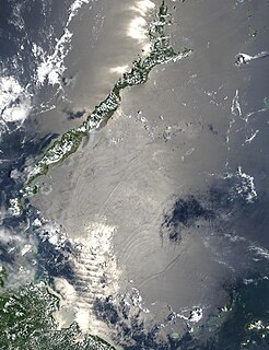
The Sulu Sea is a body of water in the southwestern area of the Philippines, separated from the South China Sea in the northwest by Palawan and from the Celebes Sea in the southeast by the Sulu Archipelago. Borneo is found to the southwest and Visayas to the northeast.

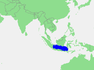
The Java Sea is an extensive shallow sea on the Sunda Shelf. It lies between the Indonesian islands of Borneo to the north, Java to the south, Sumatra to the west, and Sulawesi to the east. Karimata Strait to its northwest links it to the South China Sea. It is a part of the western Pacific Ocean.

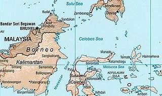
The Celebes Sea of the western Pacific Ocean is bordered on the north by the Sulu Archipelago and Sulu Sea and Mindanao Island of the Philippines, on the east by the Sangihe Islands chain, on the south by Sulawesi's Minahasa Peninsula, and on the west by northern Kalimantan in Indonesia. It extends 420 miles (675 km) north-south by 520 mi (840 km) east-west and has a total surface area of 110,000 square miles (280,000 km2), to a maximum depth of 20,300 feet (6,200 m). South of the Mangkalihat Peninsula, the sea opens southwest through the Makassar Strait into the Java Sea.

The Natuna Regency is an archipelago of 272 islands located in the south part of the South China Sea in the Natuna Sea. It is part of the larger Tudjuh Archipelago, off the northwest coast of Borneo. Administratively, the islands constitute a regency within the Riau Islands Province of Indonesia and are the northernmost non-disputed island group of Indonesia.

The Bunguran Islands are an archipelago in Riau Islands province, Indonesia, located in the Natuna Sea, the southern portion of the South China Sea. The archipelago forms the central part of the Natuna Regency, an archipelago of 272 islands in total, which is in turn included in the Tudjuh Archipelago, off the northwest coast of Borneo. The largest island of the archipelago is Bunguran or Pulau Natuna Besar, situated in the Middle Natuna Archipelago. The group covers a land area of 1,698.6 km2 and had a population of 52,013 at the 2010 Census. It is divided into nine districts (kecamatan) – seven of which are tabulated below from north to south with their areas and 2010 Census populations, plus the number of administrative villages within that district and the postcode:

Anambas Islands Regency is a small archipelago of Indonesia, located 150 nautical miles northeast of Batam Island in the North Natuna Sea between the Malaysian mainland to the west and the island of Borneo to the east. Geographically part of the Tudjuh Archipelago, it is administratively a regency within the Riau Islands Province. It covers a land area of 590.2 km2 and had a population of 37,411 at the 2010 Census. The administrative centre is at Tarempa on Siantan Island.

The Flores Sea covers 240,000 square kilometres (93,000 sq mi) of water in Indonesia. The sea is bounded on the north by the island of Celebes and on the south by Sunda Islands of Flores and Sumbawa.

The Molucca Sea is located in the western Pacific Ocean, around the vicinity of Indonesia, specifically bordered by the Indonesian Islands of Celebes (Sulawesi) to the west, Halmahera to the east, and the Sula Islands to the south. The Molucca Sea has a total surface area of 77,000 square miles. The Molucca Sea is rich in coral and has many diving sites due to the deepness of its waters. The deepness of the water explains the reasoning behind dividing the sea into three zones, which functions to transport water from the Pacific Ocean to the shallower seas surrounding it. The deepest hollow in the Molucca Sea is the 15,780-foot (4,810-meter) Batjan basin. This region is known for its periodic experiences of earthquakes, which stems from the sea itself being a micro plate, in which the Molucca Sea is being subducted in two opposite directions: one in the direction of the Eurasian Plate to the west and the other in the direction of the Philippines Sea Plate to the east.
The Solor Archipelago is a group of islands in the Lesser Sunda Islands, Indonesia, lying to the east of Flores and to the west of the Alor Strait and the Alor Archipelago. To the north is the west part of the Banda Sea, while to the south across the Savu Sea lies the island of Timor. The largest islands are, from west to east, Solor, Adonara, and Lembata, although there are many small islands as well.

Cenderawasih Bay, also known as Sarera Bay and formerly Geelvink Bay, is a large bay in northern Province of Papua and West Papua, New Guinea, Indonesia.
Tambelan archipelago is a group of 68 islands off the west coast of West Kalimantan, (Borneo), Indonesia, just north of the equator. The archipelago is located on the north opening of Karimata Strait which separates Borneo and Belitung island. Geographically it is part of the Tudjuh Archipelago, and administratively forms a district (kecamatan) of Bintan Regency within the Riau Islands Province. It covers a land area of 90.4 km2 and had a population of 4,975 at the 2010 Census. Major islands include Big Tambelan, Mendarik, Uwi, Benua, and Pejantan. The islands are divided into eight administrative villages (kelurahan) - Batu Lepuk, Kampung Hilir, Kampung Melayu, Kukup, Pengikik, Pulau Mentebung, Pulau Pinang and Teluk Sekuni.
South Natuna is an archipelago off the west coast of the island of Borneo, the southernmost group of the Natuna Islands in the South China Sea. Geographically it is part of the Tudjuh Archipelago, and administratively part of the Riau Islands province of Indonesia.
Badas Islands is a group of islands in the Tudjuh Archipelago in the South China Sea between the Malaysian mainland to the west and the island of Borneo to the east. Administratively it is part of Bintan Regency within the Riau Islands province of Indonesia.

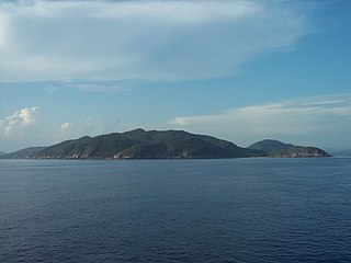
Sabi Island is an island in the Mergui Archipelago of Taninthayi Region, Burma (Myanmar). It lies between Money Island to the south and Parker Island to the north. The narrow channel between Sabi island and Money Island is rather shallow, but the half-mile wide channel between Sabi Island and Parker Island is quite deep. The island is heavily forested and has small bays with sandy beaches on the west side. The highest point is 326 m above the sea. Whaleback Reef, which lies about three-quarters of mile off the northeast part of the island, is exposed about 8 ft. at low tide.
The Rukan Islands, also known as the Three Brothers, is a group of three small islands at the south entrance of Durian Strait, in the Riau Islands Province of Indonesia, off the north coast of Sumatra near Singapore. The group extends about 7.2 km north to south, and is surrounded by many dangerous wrecks.
Little Karimun is an island in the Strait of Malacca, about 58 kilometres (36 mi) west of Batam and 35 km south-west of Singapore. It belongs to the Karimun Regency of the Riau Islands Province of Indonesia. It is located just off the east coast of Sumatra.

The Thousand Islands are a chain of islands to the north of Jakarta's coast. It forms the only regency of Jakarta, the capital of Indonesia. It consists of a string of 342 islands stretching 45 km (28 mi) north into the Java Sea at West Jakarta Bay and in fact north of Banten Province.

Soop, also known as Sop or Tsiof, is an island in West Papua, Indonesia, located in the north of Sele Strait, and off the northwestern coast of the Bird's Head Peninsula. It lies at a distance of about 4 kilometres (2.5 mi) west of the city of Sorong on the mainland, 2.5 kilometres (1.6 mi) west of the island of Doom, 3 kilometres (1.9 mi) northwest of the uninhabited island of Nana, 6 kilometres (3.7 mi) north-east of the island of Yefman, and 5 kilometres (3.1 mi) south of the island of Raam. Soop is 3.3 kilometres (2.1 mi) long and up to 1.3 kilometres (0.81 mi) wide, with an area of 2.67 square kilometres (1.03 sq mi).

Raam, also spelt Ram, is an island in West Papua, Indonesia, located off the northwestern tip of the Bird's Head Peninsula of New Guinea. It lies at a distance of about 2 kilometres (1.2 mi) from the coast of the city of Sorong, and about 5 kilometres (3.1 mi) north of the islands of Doom and Soop. About 1.6 kilometres (0.99 mi) long and up to 0.5 kilometres (0.31 mi) wide, Raam has an area of 0.5 square kilometres (0.19 sq mi). Occupying the eastern half of the island is a settlement with a population of 1,570, which forms a kelurahan within the district of Kepulauan Sorong in the urban regency of Sorong.


