
The North Cascades are a section of the Cascade Range of western North America. They span the border between the Canadian province of British Columbia and the U.S. state of Washington and are officially named in the U.S. and Canada as the Cascade Mountains. The portion in Canada is known to Americans as the Canadian Cascades, a designation that also includes the mountains above the east bank of the Fraser Canyon as far north as the town of Lytton, at the confluence of the Thompson and Fraser Rivers.

The North Santiam River is a 92-mile (148 km) tributary of the Santiam River in western Oregon in the United States. It drains 766 square miles (1,980 km2) of the Cascade Range on the eastern side of the Willamette Valley east of Salem.
The Siskiyou Mountains salamander, also called the Siskiyou Mountain salamander, exists only in isolated locations along the Klamath River in northern California and southern Oregon. It is a close relative of the Del Norte salamander, and some herpetologists believe it may be a subspecies of that animal.
The northwestern salamander is a species of mole salamander that inhabits the northwest Pacific coast of North America. These fairly large salamanders grow to 8.7 in (220 mm) in length. It is found from southeastern Alaska on May Island, through Washington and Oregon south to the mouth of the Gualala River, Sonoma County, California. It occurs from sea level to the timberline, but not east of the Cascade Divide. Its range includes Vancouver Island in British Columbia and The San Juan Islands, Cypress, Whidbey, Bainbridge, and Vashon Islands in Washington.

The genus Taricha consists of four species of highly toxic newts in the family Salamandridae. Their common name is Pacific newts, sometimes also western newts or roughskin newts. The four species within this genus are the California newt, the rough-skinned newt, the red-bellied newt, and the sierra newt, all of which are found on the Pacific coastal region from southern Alaska to southern California, with one species possibly ranging into northern Baja California, Mexico.
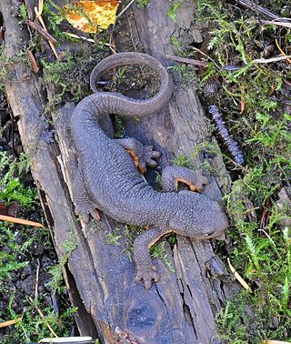
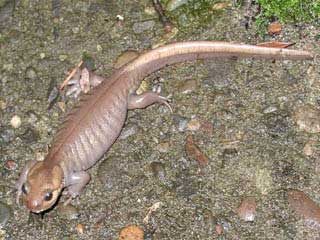
The rough-skinned newt or roughskin newt is a North American newt known for the strong toxin exuded from its skin.
The Pasayten River is a tributary of the Similkameen River, in the Canadian province of British Columbia and the U.S. state of Washington. The Pasayten River is part of the Columbia River drainage basin, being a tributary of the Similkameen River, which flows into the Okanagan River, which flows into the Columbia River.
The Crater Lake newt or Mazama newt, Taricha granulosa mazamae, is a subspecies of the rough-skinned newt. Its type locality is Crater Lake, Oregon. Similar newts have been found in Alaska, but their identity is unclear.
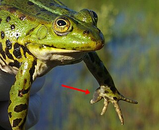
A nuptial pad is a secondary sex characteristic present on some mature male frogs and salamanders. Triggered by androgen hormones, this breeding gland appears as a spiked epithelial swelling on the forearm and prepollex that aids with grip, which is used primarily by males to grasp females during amplexus. They can also be used in male–male combat in some species.
Megalobatrachonema is a nematode genus. Species of this genus are parasites of a number of amphibians including the rough-skinned newt.
Karotomorpha is a genus of parasites with a flagellum structure. This organism can infect a variety of higher life forms including a number of amphibians. For example, this genus is known to be a parasite of the rough-skinned newt, a widespread newt in the western USA.
Cephalouterina is a genus of trematodes within the family Lecithodendriidae under the order Plagiorchiida. Individuals of this genus are known to use amphibian hosts.
Cephalouterina decamptodoni is a species of trematodes within the family Lecithodendriidae under the order Plagiorchiida. This species is sometimes known to use amphibian hosts.
Marion Lake is a subalpine lake located in Linn County of the U.S. state of Oregon. The lake is in central Oregon's Cascades within the Mount Jefferson Wilderness. The lake is approximately 300 acres (1.2 km2), at an elevation of 4,134 feet (1,260 m).
Perennibranchiate, in zoology, is the condition of an organism retaining branchae, or gills, through life. This condition is generally said of certain amphibia, such as the mudpuppy. The term is opposed to caducibranchiate. In some cases only a small proportion of a given amphibian population is perennibranchiate, but in other instances a preponderance of the individuals have an adult gill retention. For example, in the case of the Rough-skinned Newt in the Cascade Mountains populations, approximately ninety percent of the adult population is perennibranchiate.

The Hozameen Range is a mountain range in southwestern British Columbia and northern Washington, straddling the division between the Coast and Interior regions of that province. It is a subrange of the North Cascades and is neighboured on the east by the Okanagan Range and on the northwest by the unofficially-named Coquihalla Range, which lies between that river and the Fraser. In the northwest part of the range is the one named subrange, the Bedded Range.

The Bedded Range is a mountain range in the Hozameen Range subdivision of the Canadian Cascades, which are the extension of the Cascade Range into British Columbia, Canada. Located between the Coquihalla and Tulameen Rivers, the Bedded Range is a dioritic plug related to the Chilliwack batholith.

There are 14 species of amphibians and 5 species of reptiles known to occur in Mount Rainier National Park.
