Related Research Articles

Otero County is a county located in the U.S. state of New Mexico. As of the 2020 census, the population was 67,839. Its county seat is Alamogordo. Its southern boundary is the Texas state line. It is named for Miguel Antonio Otero, the territorial governor when the county was created.

Alamogordo is the County seat of Otero County, New Mexico, United States. A city in the Tularosa Basin of the Chihuahuan Desert, it is bordered on the east by the Sacramento Mountains and to the west by Holloman Air Force Base. The population was 31,384 as of the 2020 census. Alamogordo is widely known for its connection with the 1945 Trinity test, which was the first ever explosion of an atomic bomb.

La Luz is a census-designated place (CDP) in Otero County, New Mexico, United States. The population was 1,615 at the 2000 census. It is located immediately north of Alamogordo and lies in the eastern edge of the Tularosa Basin and on the western flank of the Sacramento Mountains. Until 1848, La Luz was a part of Mexico. The CDP gets its name from the Spanish word for "light".
Mescalero is a census-designated place (CDP) in Otero County, New Mexico, United States, located on the Mescalero Apache Reservation. The population was 1,338 at the 2010 census.

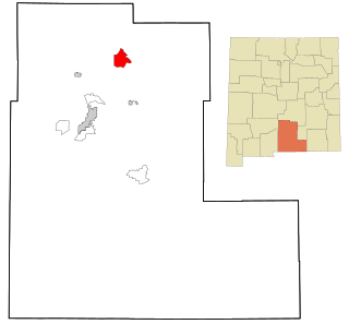
Tularosa is a village in Otero County, New Mexico, United States. It shares its name with the Tularosa Basin, in which the town is located. To the east, Tularosa is flanked by the western edge of the Sacramento Mountains. The population was 2,553 at the 2020 census. During the 1990s and early 2000s, the town, north of the much larger Alamogordo, experienced moderate growth and construction as a bedroom community, especially in the housing industry. Tularosa is noted for its abundance of cottonwood shade trees and its efforts to preserve the adobe-style architecture of its past.

Jefferson County School District R-1 is a school district in Jefferson County, Colorado, United States. The district is headquartered at the Jeffco Public Schools Education Center in an unincorporated area of the county near Golden in the Denver metropolitan area. Jeffco Public Schools serves almost 81,000 students in 166 schools. It is the second-largest school district in Colorado, having been surpassed in 2013 by Denver Public Schools, which has an enrollment of approximately 81,000.
Pulaski County Special School District No. 1 (PCSSD) is one of four public school districts in Pulaski County, Arkansas—along with the Little Rock School District, the North Little Rock School District, and the Jacksonville North Pulaski School District—accredited by the Arkansas Department of Education. PCSSD has its headquarters in Sweet Home, an unincorporated area near southeastern Little Rock; the headquarters has a Little Rock postal address.
Frenship Independent School District is a public school district based in Wolfforth, Texas, United States.
Rockwall Independent School District is a public school district established in 1841 in Rockwall, Texas.

High Rolls is an unincorporated community and census-designated place in Otero County, New Mexico, United States. It is nestled within the Lincoln National Forest at the southernmost tip of the Sacramento Mountains.

Mountain Park is an unincorporated community in Otero County, New Mexico, United States. It is located at 32.951°N, 105.824°W, and its elevation is 6710 feet.
The Gadsden Independent School District (GISD) is a New Mexico school district headquartered in Sunland Park. Gadsden ISD's superintendent is currently Travis Dempsey who was appointed by the board of education after Efren Yturralde's resignation June 2017. GISD serves Doña Ana County and southern Otero County with a total territory of 1,400 square miles (3,600 km2). The school district is named for James Gadsden.
Orogrande is an unincorporated community in Otero County, New Mexico, United States, located in the Jarilla Mountains of the Tularosa Basin on U.S. 54 between El Paso, Texas and Alamogordo. The community had a population of 52 in the 2010 census.
Santa Fe Public Schools (SFPS) is a school district based in Santa Fe, New Mexico. Santa Fe Public Schools serves the city of Santa Fe, the communities of Tesuque and Eldorado, and the historic neighborhood of Agua Fria, and other communities with a total area of 1,016 square miles (2,630 km2). The school district has a total of 31 schools: three high schools, three combined high/middle schools, three middle schools, and 21 elementary schools.
Weed is a hamlet and a census-designated place in Otero County, New Mexico, United States. It lies alongside New Mexico State Road 24 on the southeastern slopes of the Sacramento Mountains at an elevation of 7,215 ft. It has had a Post Office since 1885. As of the 2010 census, its population was 63.
The Alamagordo Municipal School District No. 1, also the Alamogordo Public School District or Alamogordo Public Schools (APS), is a school district that serves the communities of Alamogordo, High Rolls, Holloman Air Force Base, Mountain Park, and La Luz and portions of unincorporated Otero County in the state of New Mexico.
Bent is a census-designated place in Otero County, New Mexico, United States. Its population was 119 as of the 2010 census. Bent has a post office with ZIP code 88314. U.S. Route 70 passes through the community.
Cloudcroft Municipal Schools is a school district headquartered in Cloudcroft, New Mexico. It includes Cloudcroft Elementary/Middle School and Cloudcroft High School.
Moriarty-Edgewood School District (MESD), also known as Moriarty Municipal Schools, is a school district headquartered in unincorporated Torrance County, New Mexico, near Moriarty.
References
- 1 2 3 "Search for Public School Districts – District Detail for TULAROSA MUNICIPAL SCHOOLS". National Center for Education Statistics . Institute of Education Sciences.
- ↑ "2020 CENSUS - SCHOOL DISTRICT REFERENCE MAP: Otero County, NM" (PDF). U.S. Census Bureau . Retrieved July 27, 2021.
- ↑ "Tularosa Municipals Schools". Tularosa Municipals Schools. Retrieved June 25, 2012.