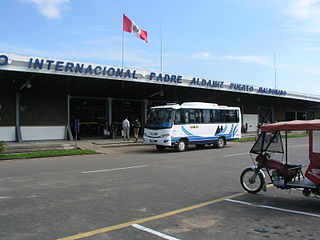
Padre Aldamiz International Airport, also known as Puerto Maldonado International Airport, is an airport serving the city of Puerto Maldonado in the Madre de Dios Region of Peru. The airport oversees a small number of domestic (national) commercial flights.

Coronel FAP Alfredo Mendívil Duarte Airport is an airport serving Ayacucho, Peru. It is managed by CORPAC S.A., a government organization that oversees Peruvian airports. It is the main airport of the Ayacucho Region.
Capitán FAP José A. Quiñones González International Airport is an airport serving Chiclayo, Peru and the surrounding metropolitan area. It is run by ADP a private airport operator that operates various airports in northern Peru. It is the main airport of the Lambayeque Region, one of the most populous regions of Peru.
Teniente FAP Jaime Montreuil Morales Airport is an airport serving Chimbote, in the Ancash Region of Peru. It is operated by the civil government and handles many government planes.
Alférez FAP David Figueroa Fernandini Airport is an airport serving Huánuco, Peru. It is the most important airport in the Huánuco Region and is operated by the civil government. It is currently served by 2 airlines: LC Perú, which has one daily flight to Lima, offering connections to the rest of the Peru and the world and Star Perú also with daily flights to Lima. Although there are no other regular scheduled services, the airport serves many charter and private flights.
FAP Captain David Abensur Rengifo International Airport is an airport serving the city of Pucallpa in the Ucayali Region of Peru. It is operated by Aeropuertos del Perú, S.A. Captain Rengifo Airport is the main airport serving the Ucayali Region.
Coronel FAP Carlos Ciriani Santa Rosa International Airport is an airport serving Tacna, Peru. It is run by CORPAC S.A., a government organization that oversees airport management. The airport is the main airport of the Tacna Region, and is 27 km (17 mi) north of Peru's border with Chile.
Capitán FAP Pedro Canga Rodríguez Airport is an airport serving Tumbes, Peru. It is the main airport of the Tumbes Region, and is run by CORPAC S.A., a government organization that manages Peruvian airports. The airport is used mainly by locals and national and international travelers because of its proximity to beaches and resorts.
Comandante FAP Germán Arias Graziani Airport is a regional airport serving the city of Huaraz, Ancash Region, Peru. The airport is in the Santa River valley, 20 kilometres (12 mi) northwest of Huaraz, at the village of Anta. It is currently not served by any airline due to the suspension of the scheduled airline, LC Perú. It receives many private and charter flights. It does not receive large aircraft due to high terrain in all quadrants.
Alerta Airport is an airstrip serving Alerta, a village near the Bolivian border in the Ucayali Region of Peru. The village is on the Río Muymanu (sv), a stream in the Amazon basin.
Iberia Airport is an airport serving Iberia in the Madre de Dios Region of Peru. The town is in the Amazon basin, 18 kilometres (11 mi) from the Peruvian border with Bolivia.
Santa Rosa International Airport is an airport serving Machala, the capital of El Oro Province in Ecuador. Located 20 kilometres (12 mi) south in Santa Rosa, it replaces the closed General Manuel Serrano Airport in Machala, and is designed to handle international flights from Peru.

Santa María Airport is an airport in Santa María, also known as Santa María del Mar, a district of the Lima Province in Peru.

Abapo Airport was a public use airport in the Santa Cruz Department of Bolivia.
Santa Cecilia Airport is an airport serving the village of Santa Cecilia in Sucumbíos Province, Ecuador.
Quince Mil is an airport serving the village of Quince Mil in the Cusco Region of Peru. The runway is in the strip of land between the Interoceanic Highway and the Araza River, a tributary of the Inambari River. Aerial images show brush growing mid-field.
San Nicolas Airport is an airport serving the town of Mendoza in the Amazonas Region of Peru. The runway is just west of the town, at the adjoining village of San Nicolas.
Ciro Alegria Airport is an airport serving the town of Santa María de Nieva in the Amazonas Region of Peru. The runway is 8.7 kilometres (5.4 mi) west of the town, on the opposite side of the Marañón River.
Palmapampa Airport is an airport serving the town of Palmapampa in the Ayacucho Region of Peru. The runway is just off the AY-101 Santa Rosa - Samugari Road.
Bellavista Airport is an airstrip serving the town of Jeberos in the Loreto Region of Peru.


