Tunisian salt lakes

Last updated
Tunisia adm location map.svg
Blue pog.svg
Location of the Tunisian salt lakes

The Tunisian salt lakes are a series of lakes in central Tunisia, lying south of the Atlas Mountains at the northern edge of the Sahara. The lakes include, from east to west, the Chott el Fedjedj, Chott el Djerid, and Chott el Gharsa.

Contents

Geography

These salt lakes stretch with only two short breaks in a line from the Mediterranean at the Gulf of Gabès to the Algerian frontier, which they penetrate for a considerable distance. The French term "chott" is a transliteration of the Arabic shat, a term for a broad canal, an estuary or lake. These shats however are, strictly speaking, not lakes at all at the present day. They are smooth depressed areas (in the case of the largest, the Shat el Jerid, lying a few feet below the level of the Mediterranean), which for more than half the year are expanses of dried mud covered with a thick incrustation of white or grey salt. This salt covering gives them at a distance the appearance of big sheets of water. [1]

During the winter, however, when the effect of the rare winter rains is felt, there may actually be 3 or 4 ft. of water in these shats, which by liquefying the mud makes them perfectly impassable. Otherwise, for about seven months of the year they can be crossed on foot or on horseback. It would seem probable that at one time these shats (at any rate the Shat el Jerid) were an inlet of the Mediterranean, which by the elevation of a narrow strip of land on the Gulf of Gabès has been cut off from them. It is, however, a region of past volcanic activity, and these salt depressions may be due to that cause. Man is probably the principal agent at the present day in causing these shats to be without water. All around these salt lakes there are numerous springs, gushing from the sandy hillocks. Almost all these springs are at a very hot temperature, often at boiling point. Some of them are charged with salt, others are perfectly fresh and sweet, though boiling hot. So abundant is their volume that in several places they form actual ever-flowing rivers. Only for the intervention of man these rivers would at all times find their way into the adjoining depressions, which they would maintain as lakes of water. But for a long period past the freshwater streams (which predominate) have been used for irrigation to such a degree that very little of the precious water is allowed to run to waste into the lake basins; so that these latter receive only a few salt streams, which deposit on their surface the salt they contain and then evaporate. This abundant supply of fresh warm water maintains oases of extraordinary luxuriance in a country where rain falls very rarely. Perennial streams of the description referred to are found between the Algerian frontier and Gabès on the coast. The town at Gabès itself is on the fringe of a splendid oasis, which is maintained by the water of an ever-running stream emptying itself into the sea at Gabès after a course of not more than 20 miles. [1]

All this region round the shats has been called the "Jerid" from the time of the Arab occupation. "Jerid" means in Arabic a "palm frond" and inferentially "a palm grove." The fame of this Belad-el-Jerid, or "Country of the Date Palms", was so exaggerated during the 17th and 18th centuries that the European geographers extended the designation from this small area in the south of Tunisia to cover much of inner Africa. With this country of Jerid may be included the island of Jerba, which lies close to the coast of Tunisia in the Gulf of Gabès. The date palm (Phoenix dactylifera) may be indigenous to this district of the Jerid, as it is to countries of similar description in southern Morocco, southern Algeria, parts of the Tripolitania, Egypt, Mesopotamia, southern Persia and north-western India; but that north of the latitude of the Jerid the date did not grow naturally in Mauretania, just as it was foreign to all parts of Europe, in which, as in true North Africa, its presence is due to the hand of man. To some extent it may be said that true North Africa lies to the north of the Jerid country, which, besides its Saharan, Arabian and Persian affinities, has a touch about it of real Africa, some such touch as may be observed in the valley of the Jordan. In the oases of the Jerid are found several species of tropical African mammals and two or three of Senegalese birds, and the vegetation seems to have as much affinity with tropical Africa as with Europe. In fact, the country between the Matmata highlands and the strait separating Jerba from the mainland is singularly African in the character and aspect of its flora. To the south of the Jerid the country is mainly desert — vast unexplored tracts of shifting sand, with rare oases. Nevertheless, all this southern district of Tunisia bears evidence of once having been subject to a heavy rainfall, which scooped out deep valleys in the original table-land, and has justified the present existence of immense watercourses — watercourses which are still, near their origin, favoured with a little water. [1]

The narrow sandy ridge separating the Chott el Fejej from the Mediterranean Sea brought it to the attention of various geographers, engineers and diplomats. These figures looked to create an inland "Sahara Sea" by channelling the waters of the Mediterranean into Sahara Desert basins which lay below sea level. A noted proposal to this effect was put forward in the late 1800s by French geographer François Élie Roudaire and the creator of the Suez Canal, Ferdinand de Lesseps, but stalled after the French government withdrew funding. [2] [3] [4] Later proposals, made as part of Operation Plowshare, [5] posited that nuclear explosives could be used to dig the proposed canal from the Mediterranean to the Chott el Fejej and other below-sea-level basins of the Sahara; these proposals were also fruitless. [6]

See also

Related Research Articles

<span class="mw-page-title-main">Geography of Libya</span> Geographical features of Libya

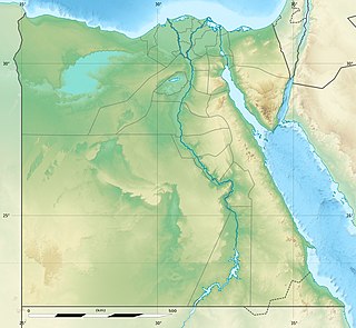
Libya is fourth in size among the countries of Africa and sixteenth among the countries of the world. It is on the Mediterranean between Egypt and Tunisia, with Niger and Chad to the south and Sudan to the southeast. Although the oil discoveries of the 1960s have brought immense wealth, at the time of its independence it was an extremely poor desert state whose only important physical asset appeared to be its strategic location at the midpoint of Africa's northern rim.

<span class="mw-page-title-main">Oasis</span> Fertile area in a desert environment

In geography, an oasis is a fertile land in a desert or semi-desert environment. Oases also provide habitats for animals and plants.

<span class="mw-page-title-main">Geography of Tunisia</span>

Tunisia is a country in Northern Africa, bordering the Mediterranean Sea, having a western border with Algeria (965 km) and south-eastern border with Libya (459 km) where the width of land tapers to the south-west into the Sahara. The country has north, east and complex east-to-north coasts including the curved Gulf of Gabès, which forms the western part of Africa's Gulf of Sidra. Most of this greater gulf forms the main coast of Libya including the city of Sirte which shares its root name. The country's geographic coordinates are 34°00′N9°00′E. Tunisia occupies an area of 163,610 square kilometres, of which 8,250 are water. The principal and reliable rivers rise in the north of the country with a few notable exceptions from north-east Algeria and flow through the northern plain where sufficient rainfall supports diverse plant cover and irrigated agriculture.

In geology, a chott, shott, or shatt is a salt lake in Africa's Maghreb that stays dry for much of the year but receives some water in the winter. The elevation of a chott surface is controlled by the position of the water table and capillary fringe, with sediment deflation occurring when the water table falls and sediment accumulation occurring when the water table rises. They are formed—within variable shores—by the spring thaw from the Atlas mountain range, along with occasional rainwater or groundwater sources in the Sahara, such as the Bas Saharan Basin.

<span class="mw-page-title-main">Djerid</span> One of the six geographical and economic regions of Tunisia

el-Djerid, also al-Jarīd or more precisely the South Western Tunisia Region is a semi-desert natural region comprising three southern Tunisian Governorates, Gafsa, Kebili and Tozeur with adjacent parts of Algeria and Libya.

<span class="mw-page-title-main">Tozeur</span> City in Tozeur Governorate, Tunisia

Tozeur is a city in southwest Tunisia. The city is located northwest of Chott el Djerid, in between this Chott and the smaller Chott el Gharsa. It is the capital of Tozeur Governorate. It was the site of the ancient city and former bishopric Tusuros, which remains a Latin Catholic titular see.

<span class="mw-page-title-main">El Oued Province</span> Province of Algeria

El Oued is a Saharan province of Algeria dominated by Oued Souf. It was named after its eponymous capital. Notable towns include El Oued itself and El M'Ghair, Djamaa and Guemar.

<span class="mw-page-title-main">Gulf of Gabès</span> Body of water

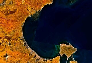
The Gulf of Gabes, also known as Lesser Syrtis, contrasting with the Greater Syrtis in Libya, is a gulf on Tunisia's east coast in the Mediterranean Sea, off North Africa. The gulf roughly spans the coast from Sfax to Djerba. At the head of the gulf is the city of Gabès (Ghannouche) where the tides have a large range of up to 2.1 m at spring tides. Both Gabès and Sfax are major ports on the gulf, supporting sponge and tuna fisheries, with Gabès being the economic and administrative center.

Lake Tritonis, was a large body of fresh water in northern Africa that was described in many ancient texts. Classical-era Greek writers placed the lake in what today is southeastern Algeria and southern Tunisia. In details of the late myths and personal observations related by these historians, the lake was said to be named after Triton. According to Herodotus it contained two islands, Phla, which the Lacedaemonians were to have colonized, according to an oracle, and Mene.

<span class="mw-page-title-main">Gabès Governorate</span> Governorate of Tunisia

Gabès Governorate is one of the 24 governorates of Tunisia and in south-eastern Tunisia. It covers an area of 7166 km2 and had a population of 374,300 as at the 2014 census. The capital is Gabès.

<span class="mw-page-title-main">Chott el Djerid</span> Body of water

Chott el Djerid also spelled Sciott Gerid and Shott el Jerid, is a large endorheic salt lake in southern Tunisia. The name can be translated from the Arabic into English as "Lagoon of the Land of Palms".

<span class="mw-page-title-main">Chott Melrhir</span> Body of water

Chott Melrhir also known as Chott Melghir or Chott Melhir is an endorheic salt lake in northeastern Algeria. It is the westernmost part of a series of depressions, which extend from the Gulf of Gabès into the Sahara. They were created between Miocene and Early Pleistocene as a result of compression accompanying the formation of the Atlas Mountains. With the maximum area of about 6,700 km2 (2,600 sq mi), it is the largest lake in Algeria. It lies almost entirely below sea level and contains the lowest point in Algeria, −40 meters. Its size varies over the year and is usually larger than 130 km (81 mi) from east to west. The nearby cities are Biskra, El Oued and Touggourt.

Grand Erg Oriental Erg in Algeria and Tunisia

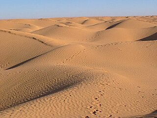
The Grand Erg Oriental is a large erg or "field of sand dunes" in the Sahara Desert. Situated for the most part in Saharan lowlands of northeast Algeria, the Grand Erg Oriental covers an area some 600 km wide by 200 km north to south. The erg's northeastern edge spills over into neighbouring Tunisia.

<span class="mw-page-title-main">Outline of Tunisia</span> Overview of and topical guide to Tunisia

The following outline is provided as an overview of and topical guide to Tunisia:

<span class="mw-page-title-main">El Hamma</span> Place in Gabès Governorate, Tunisia

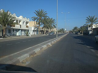
El Hamma is an oasis town located in the Gabès Governorate, 30 kilometers west of Gabès, Tunisia and near the eastern end of Chott el Fejej. Its population in 2014 was 73,512.

<span class="mw-page-title-main">Sahara Sea</span> Engineering project to flood parts of the Sahara Desert with sea water.

The Sahara Sea was the name of a hypothetical macro-engineering project which proposed flooding endorheic basins in the Sahara Desert with waters from the Atlantic Ocean or Mediterranean Sea. The goal of this unrealized project was to create an inland sea that would cover the substantial areas of the Sahara Desert which lie below sea level, bringing humid air, rain, and agriculture deep into the desert.

<span class="mw-page-title-main">François Élie Roudaire</span>

François Élie Roudaire was a French author, military officer and geographer. He, along with Ferdinand de Lesseps, was a proponent of creating an inland Sahara Sea by flooding areas of the Sahara Desert which were below sea level.

Chott el Fejej, also known as Chott el Fedjedj and Chott el Fejaj, is a long, narrow inlet of the endorheic salt lake Chott el Djerid in southern Tunisia.

Mediterranean Wetlands comprise the wetlands of the Mediterranean region.

<span class="mw-page-title-main">Saharan halophytics</span> Ecoregion (WWF)

The Saharan halophytics ecoregion covers a series of low-lying evaporite depressions and wetlands spread across North Africa. The depressions are characteristically saline, variously chotts or sabkhas. The plants of the areas are highly specialized to survive in the harsh environment, with many being xerophytes (drought-tolerant) and halophytes (salt-tolerant). The biodiversity of the areas has been relatively protected by their isolation, and unsuitability of alkaline soil for farming.

References

  1. 1 2 3 Wikisource-logo.svg One or more of the preceding sentences incorporates text from a publication now in the public domain : Johnston, Harry (1911). "Tunisia". In Chisholm, Hugh (ed.). Encyclopædia Britannica . Vol. 27 (11th ed.). Cambridge University Press. p. 394.
  2. Plummer, Harry Chapin (1913). "A Sea in the Sahara". National Waterways: A Magazine of Transportation. National Rivers and Harbors Congress. 1 (2): 131–138. Retrieved 16 December 2012.
  3. Spinage, Clive Alfred (2012). African Ecology: Benchmarks and Historical Perspectives. Springer Geography (Illustrated ed.). New York: Springer. ISBN   3642228712 . Retrieved 16 December 2012.
  4. McKay, Donald Vernon (1943). "Colonialism in the French geographical movement 1871-1881". Geographical Review. American Geographical Society. 33 (2): 214–232. doi:10.2307/209775. JSTOR   209775.
  5. Barletta, Michael (August 2001). Pernicious ideas in world politics: "Peaceful nuclear explosives" (PDF). San Francisco, CA: Annual Meeting of the American Political Science Association. Retrieved 16 December 2012.
  6. Jousiffe, Ann (2010). Tunisia. Globetrotter: Guide and Map Series (4th ed.). London: New Holland Publishers. ISBN   1845378644 . Retrieved 16 December 2012.