Related Research Articles

The Central Pacific Railroad (CPRR) was a rail company chartered by U.S. Congress in 1862 to build a railroad eastwards from Sacramento, California, to complete most of the western part of the "First transcontinental railroad" in North America. Incorporated in 1861, CPRR ceased independent operations in 1885 when the railroad was leased to the Southern Pacific Railroad. Its assets were formally merged into Southern Pacific in 1959.

Theodore Dehone Judah was an American civil engineer who was a central figure in the original promotion, establishment, and design of the First transcontinental railroad. He found investors for what became the Central Pacific Railroad (CPRR). As chief engineer, he performed much of the route survey work to determine the best alignment for the railroad over the Sierra Nevada, which was completed six years after his death.

America's first transcontinental railroad was a 1,911-mile (3,075 km) continuous railroad line built between 1863 and 1869 that connected the existing eastern U.S. rail network at Council Bluffs, Iowa, with the Pacific coast at the Oakland Long Wharf on San Francisco Bay. The rail line was built by three private companies over public lands provided by extensive U.S. land grants. Building was financed by both state and U.S. government subsidy bonds as well as by company-issued mortgage bonds. The Western Pacific Railroad Company built 132 miles (212 km) of track from the road's western terminus at Alameda/Oakland to Sacramento, California. The Central Pacific Railroad Company of California (CPRR) constructed 690 miles (1,110 km) east from Sacramento to Promontory Summit, Utah Territory. The Union Pacific Railroad (UPRR) built 1,085 miles (1,746 km) from the road's eastern terminus at the Missouri River settlements of Council Bluffs and Omaha, Nebraska, westward to Promontory Summit.

Promontory is an area of high ground in Box Elder County, Utah, United States, 32 mi (51 km) west of Brigham City and 66 mi (106 km) northwest of Salt Lake City. Rising to an elevation of 4,902 feet (1,494 m) above sea level, it lies to the north of the Promontory Mountains and the Great Salt Lake. It is notable as the location of Promontory Summit, where the first transcontinental railroad in the United States, from Sacramento to Omaha, was officially completed on May 10, 1869. The location is sometimes confused with Promontory Point, a location further south along the southern tip of the Promontory Mountains. Both locations are significant to the Overland Route: Promontory Summit was where the original, now abandoned, alignment crossed just north of the Promontory Mountains; while Promontory Point is where the modern alignment, called the Lucin Cutoff, crosses the southern tip of the Promontory Mountains.

The Southern Pacific was an American Class I railroad network that existed from 1865 to 1996 and operated largely in the Western United States. The system was operated by various companies under the names Southern Pacific Railroad, Southern Pacific Company and Southern Pacific Transportation Company.
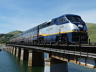
The Capitol Corridor is a 168-mile (270 km) passenger train route in Northern California operated by Amtrak between San Jose, in the Bay Area, and Auburn, in the Sacramento Valley. The route is named after the two points most trains operate between, San Jose and Sacramento. The route runs roughly parallel to I-880 and I-80. Some limited trips run between Oakland and San Jose. A single daily round trip runs between San Jose and Auburn, in the foothills of the Sierra Nevada. Capitol Corridor trains started in 1991.

Donner Pass is a 7,056-foot-high (2,151 m) mountain pass in the northern Sierra Nevada, above Donner Lake and Donner Memorial State Park about 9 miles (14 km) west of Truckee, California. Like the Sierra Nevada themselves, the pass has a steep approach from the east and a gradual approach from the west.

The California State Railroad Museum is a museum in the California State Parks system that interprets the role of railroads in the Western U.S.. It is located in Old Sacramento State Historic Park at 111 I Street, Sacramento, California.
The Western Pacific Railroad was a Class I railroad in the United States. It was formed in 1903 as an attempt to break the near-monopoly the Southern Pacific Railroad had on rail service into northern California. WP's Feather River Route directly competed with SP's portion of the Overland Route for rail traffic between Salt Lake City/Ogden, Utah, and Oakland, California, for nearly 80 years. The Western Pacific was one of the original operators of the California Zephyr passenger line.
The term ruling grade is usually used as a synonym for "steepest climb" between two points on a railroad. More simply, the steepest grade to be climbed dictates how powerful the motive power must be in order for the run to be made without assistance. Even if 99% of the line could be run with a low-powered locomotive, if at some point on the line there is a steeper gradient than such train would be able to climb, this gradient "rules" that a more powerful locomotive must be used, in spite of it being far too powerful for the rest of the line. This is why special "helper engines" are often stationed near steep grades on otherwise mild tracks. It is cheaper than running a too-powerful locomotive over the entire track mileage just in order to make the grade, especially when multiple trains run over the line each day.
The Pacific Railroad Surveys (1853–1855) were a series of explorations of the American West designed to find and document possible routes for a transcontinental railroad across North America. The expeditions included surveyors, scientists, and artists and resulted in an immense body of data covering at least 400,000 square miles (1,000,000 km2) on the American West. "These volumes... constitute probably the most important single contemporary source of knowledge on Western geography and history and their value is greatly enhanced by the inclusion of many beautiful plates in color of scenery, native inhabitants, fauna and flora of the Western country." Published by the United States War Department from 1855 to 1860, the surveys contained significant material on natural history, including many illustrations of reptiles, amphibians, birds, and mammals. In addition to describing the route, these surveys also reported on the geology, zoology, botany, paleontology, climatology of the land as well as provided ethnographic descriptions of the Native peoples encountered during the surveys. Importantly, a map of routes for a Pacific railroad, was compiled to accompany the report.

Sugar Bowl is a ski and snowboard area in northern Placer County near Norden, California along the Donner Pass of the Sierra Nevada, approximately 46 mi (74 km) west of Reno, Nevada on Interstate 80, that opened on December 15, 1939. Sugar Bowl is a medium-sized ski area in the Lake Tahoe region, and is well known for its long history, significant advanced terrain, high annual snowfall and being one of the closest ski areas to the San Francisco Bay Area. Sugar Bowl's terrain is 17% Beginner, 45% Intermediate and 38% Advanced.
The Feather River Route is a rail line that was built and operated by the Western Pacific Railroad. It was constructed between 1906 and 1909, and connects the cities of Oakland, California, and Salt Lake City, Utah. The line was built to compete with the Central Pacific Railroad, which at the time held a nearly complete monopoly on Northern California rail service. The route derives its name from its crossing of the Sierra Nevada, where it follows both the North and Middle Forks of the Feather River. The route is famous for its impressive engineering qualities and its considerable scenic value. All of the route is now owned and operated by the Union Pacific Railroad; however, the Union Pacific has transferred significant portions of the route to other lines. The portion still called the Feather River Route by the Union Pacific runs from the California Central Valley to Winnemucca, Nevada and has been divided into three subdivisions named the Sacramento, Canyon and Winnemucca subdivisions.

The Overland Route was a train route operated jointly by the Union Pacific Railroad and the Central Pacific Railroad/Southern Pacific Railroad, between the eastern termini of Council Bluffs, Iowa, and Omaha, Nebraska, and the San Francisco Bay Area, over the grade of the first transcontinental railroad which opened on May 10, 1869. Passenger trains that operated over the line included the Overland Flyer, later renamed the Overland Limited, with its eastern terminal in Chicago.
The Western Pacific Railroad (1862–1870) was formed in 1862 to build a railroad from Sacramento, California, to the San Francisco Bay, the westernmost portion of the First transcontinental railroad. After the completion of the railroad from Sacramento to Alameda Terminal on September 6, 1869, and then the Oakland Pier on November 8, 1869, which was the Pacific coast terminus of the transcontinental railroad, the Western Pacific Railroad was absorbed in 1870 into the Central Pacific Railroad.

The Central Corridor is a rail line operated by the Union Pacific Railroad from near Winnemucca, Nevada to Denver, Colorado in the western United States. The line was created after the merger with the Southern Pacific Transportation Company by combining portions of lines built by former competitors. No portion of the line was originally built by the Union Pacific; in fact, some portions were built specifically to compete with the Union Pacific's Overland Route. The line is known for significant feats of engineering while crossing the Wasatch Mountains of Utah and the Rocky Mountains of Colorado. The line features numerous tunnels; the longest and highest of these is the Moffat Tunnel.

The California Zephyr is a long-distance passenger train operated by Amtrak between Chicago and the San Francisco Bay Area, via Omaha, Denver, Salt Lake City, and Reno. At 2,438 miles (3,924 km), it is Amtrak's longest daily route, and second-longest overall after the Texas Eagle's triweekly continuation from San Antonio to Los Angeles, with travel time between the termini taking approximately 511⁄2 hours. Amtrak claims the route as one of its most scenic, with views of the upper Colorado River valley in the Rocky Mountains, and the Sierra Nevada. The modern train is the second iteration of a train named California Zephyr; the original train was privately operated and ran on a different route through Nevada and California.
The Roseville Subdivision is a railway line in California and Nevada owned by the Union Pacific Railroad, as part of the Overland Route. It runs from Roseville, California over the Sierra Nevada to Reno, Nevada. The route originated as the initial Central Pacific Railroad segment of the first transcontinental railroad, but has since been upgraded, double tracked, or realigned in some locations. The line reaches an elevation of 6,887 feet (2,099 m) above sea level at Norden, California.

Mount Judah is an 8,243-foot-elevation (2,512 meter) mountain summit in Placer County, California, United States.

Charles Marsh was an influential figure in the building of the first transcontinental railroad, as well as in building water systems for mining in the Sierra Nevada Mountains during the California Gold Rush. He was one of the founding directors of the Central Pacific Railroad. He was a surveyor and worked with Theodore D. Judah to survey and evaluate various possible routes for the first transcontinental railroad through the Sierra Nevada. He built a number of ditches and water pipelines to serve mines and towns there, and became known as the “Father of Ditches.” He was also one of the founders of the Nevada County Narrow Gauge Railroad.
References
- ↑ Schwab, Jenell (March 21, 2012). "In search for missing skiers, officials find third man in Donner Summit train tunnel". Tahoe Daily Tribune. Retrieved November 10, 2020.
- ↑ "UP's 2nd Largest Tunnel Gets Overhaul". Union Pacific. July 15, 2013. Retrieved November 10, 2022.
- ↑ "Six Mile Tunnel Through the Sierras". The Sacramento Bee. Sacramento, California. August 17, 1901. p. 1. Retrieved February 14, 2024– via Newspapers.com.

- 1 2 3 Cobb, Daniel (July 11, 2023). "1900's Tunneling Through the Sierra". Sierra Sun. Retrieved February 14, 2024.
- ↑ McDonald, Joseph; Nelson, Brian; Olson, Brian; Iden, Michael; Fritz, Steven; Honc, Randell (January 2008). "Locomotive Exhaust Temperatures During High Altitude Tunnel Operation in Donner Pass". ASME 2008 Internal Combustion Engine Division Spring Technical Conference. pp. 375–384. doi:10.1115/ICES2008-1625. ISBN 978-0-7918-4813-5 . Retrieved November 10, 2020.
- 1 2 "Donner Pass: Southern Pacific's Sierra Crossing". Donner Summit Historical Society. Retrieved November 10, 2020.
- ↑ Signor, John (1985). Donner Pass : Southern Pacific's Sierra crossing. San Marino, Calif: Golden West Books. ISBN 9780870950940.
- ↑ Janet Fullwood (October 20, 2005). "In their tracks". Sacramento Bee. Retrieved November 10, 2020.
- ↑ "UP improves Donner Pass tunnels to bolster double-stack operations". Progressive Railroading. November 24, 2009. Retrieved May 27, 2019.