
America's first transcontinental railroad was a 1,911-mile (3,075 km) continuous railroad line built between 1863 and 1869 that connected the existing eastern U.S. rail network at Council Bluffs, Iowa, with the Pacific coast at the Oakland Long Wharf on San Francisco Bay. The rail line was built by three private companies over public lands provided by extensive U.S. land grants. Building was financed by both state and U.S. government subsidy bonds as well as by company-issued mortgage bonds. The Western Pacific Railroad Company built 132 miles (212 km) of track from the road's western terminus at Alameda/Oakland to Sacramento, California. The Central Pacific Railroad Company of California (CPRR) constructed 690 miles (1,110 km) east from Sacramento to Promontory Summit, Utah Territory. The Union Pacific Railroad (UPRR) built 1,085 miles (1,746 km) from the road's eastern terminus at the Missouri River settlements of Council Bluffs and Omaha, Nebraska, westward to Promontory Summit.
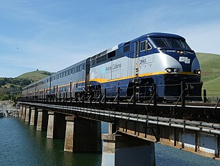
The Capitol Corridor is a 168-mile (270 km) passenger train route in Northern California operated by Amtrak between San Jose, in the Bay Area, and Auburn, in the Sacramento Valley. The route is named after the two points most trains operate between, San Jose and Sacramento. The route runs roughly parallel to I-880 and I-80. Some limited trips run between Oakland and San Jose. A single daily round trip runs between San Jose and Auburn, in the foothills of the Sierra Nevada. Capitol Corridor trains started in 1991.

State Route 14 (SR 14) is a north–south state highway in the U.S. state of California that connects Los Angeles to the northern Mojave Desert. The southern portion of the highway is signed as the Antelope Valley Freeway. Its southern terminus is at Interstate 5 in the Los Angeles neighborhoods of Granada Hills and Sylmar just immediately to the south of the border of the city of Santa Clarita. SR 14's northern terminus is at U.S. Route 395 (US 395) near Inyokern. Legislatively, the route extends south of I-5 to SR 1 in the Pacific Palisades area of Los Angeles; however, the portion south of the junction with I-5 has not been constructed. The southern part of the constructed route is a busy commuter freeway serving and connecting the cities of Santa Clarita, Palmdale, and Lancaster to the rest of the Greater Los Angeles area. The northern portion, from Vincent to US 395, is legislatively named the Aerospace Highway, as the highway serves Edwards Air Force Base, once one of the primary landing strips for NASA's Space Shuttle, as well as the Naval Air Weapons Station China Lake that supports military aerospace research, development and testing. This section is rural, following the line between the hot Mojave desert and the forming Sierra Nevada mountain range. Most of SR 14 is loosely paralleled by a rail line originally built by the Southern Pacific Railroad, and was once the primary rail link between Los Angeles and Northern California. While no longer a primary rail line, the southern half of this line is now used for the Antelope Valley Line of the Metrolink commuter rail system.

The Altamont Corridor Express is a commuter rail service in California, connecting Stockton and San Jose during peak hours only. ACE is named for the Altamont Pass, through which it runs. Service is managed by the San Joaquin Regional Rail Commission, and operations are contracted to Herzog Transit Services. The 86-mile (138 km) route includes ten stops, with travel time about 2 hours and 12 minutes end-to-end. In 2023, the line had a ridership of 576,300, or about 3,000 per weekday as of the second quarter of 2024. ACE uses Bombardier BiLevel Coaches, MPI F40PH-3C locomotives, and Siemens Charger locomotives.

Donner Pass is a 7,056-foot-high (2,151 m) mountain pass in the northern Sierra Nevada, above Donner Lake and Donner Memorial State Park about 9 miles (14 km) west of Truckee, California. Like the Sierra Nevada themselves, the pass has a steep approach from the east and a gradual approach from the west.

The Coast Starlight is a long-distance passenger train operated by Amtrak on the West Coast of the United States between Seattle and Los Angeles via Portland and the San Francisco Bay Area. The train, which has operated continuously since Amtrak's formation in 1971, was the first to offer direct service between Seattle and Los Angeles. Its name is a combination of two prior Southern Pacific (SP) trains, the Coast Daylight and the Starlight.
The California Western Railroad, AKA Mendocino Railway, popularly called the Skunk Train, is a rail freight and heritage railroad transport railway in Mendocino County, California, United States, running from the railroad's headquarters in the coastal town of Fort Bragg to the interchange with the Northwestern Pacific Railroad at Willits.
The Coast Line is a railroad line between Burbank, California and the San Francisco Bay Area, roughly along the Pacific Coast. It is the shortest rail route between Los Angeles and the Bay Area. Though not as busy as the Surf Line, the continuation of the Coast Line southbound to San Diego, it still sees freight movements and lots of passenger trains. The Pacific Surfliner, which runs from the San Diego Santa Fe Depot to San Luis Obispo via Union Station in Los Angeles, is the third busiest Amtrak route, and the busiest outside of the Northeast Corridor between Washington D.C. and Boston.
Beckwourth Pass is the lowest mountain pass in the Sierra Nevada mountain range at an elevation of 5,221 feet (1,591 m).
The Feather River Route is a rail line that was built and operated by the Western Pacific Railroad. It was constructed between 1906 and 1909, and connects the cities of Oakland, California, and Salt Lake City, Utah. The line was built to compete with the Southern Pacific Railroad, which at the time held a nearly complete monopoly on Northern California rail service. The route derives its name from its crossing of the Sierra Nevada, where it follows both the North and Middle Forks of the Feather River. The route is famous for its impressive engineering qualities and its considerable scenic value. All of the route is now owned and operated by the Union Pacific Railroad; however, the Union Pacific has transferred significant portions of the route to other lines. The portion still called the Feather River Route by the Union Pacific runs from the California Central Valley to Winnemucca, Nevada and has been divided into three subdivisions named the Sacramento, Canyon and Winnemucca subdivisions.

The Martinez subdivision is a Union Pacific railway line which runs from Roseville, California to Oakland, California. It is informally referred to as the Cal-P line, after the original California Pacific Railroad, who constructed the line from Sacramento to Suisun and Fairfield. The line is entirely double-tracked including bridges, and features extensive sidings.

The Overland Route was a train route operated jointly by the Union Pacific Railroad and the Central Pacific Railroad/Southern Pacific Railroad, between the eastern termini of Council Bluffs, Iowa, and Omaha, Nebraska, and the San Francisco Bay Area, over the grade of the first transcontinental railroad which opened on May 10, 1869. Passenger trains that operated over the line included the Overland Flyer, later renamed the Overland Limited, with its eastern terminal in Chicago.

The RF&P Subdivision is a railroad line operated by CSX Transportation and jointly owned by CSX and Virginia. It runs from Washington, D.C., to Richmond, Virginia, over lines previously owned by the Pennsylvania Railroad and the Richmond, Fredericksburg and Potomac Railroad. The line's name pays homage to that railroad, which was a predecessor to the CSX.

The Central Corridor is a rail line operated by the Union Pacific Railroad from near Winnemucca, Nevada to Denver, Colorado in the western United States. The line was created after the merger with the Southern Pacific Transportation Company by combining portions of lines built by former competitors. No portion of the line was originally built by the Union Pacific; in fact, some portions were built specifically to compete with the Union Pacific's Overland Route. The line is known for significant feats of engineering while crossing the Wasatch Mountains of Utah and the Rocky Mountains of Colorado. The line features numerous tunnels; the longest and highest of these is the Moffat Tunnel.

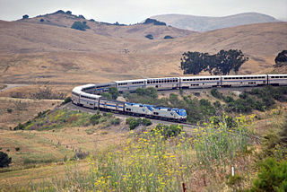
The California Zephyr is a long-distance passenger train operated by Amtrak between Chicago and the San Francisco Bay Area, via Omaha, Denver, Salt Lake City, and Reno. At 2,438 miles (3,924 km), it is Amtrak's longest daily route, and second-longest overall after the Texas Eagle's triweekly continuation from San Antonio to Los Angeles, with travel time between the termini taking approximately 511⁄2 hours. Amtrak claims the route as one of its most scenic, with views of the upper Colorado River valley in the Rocky Mountains, and the Sierra Nevada. The modern train is the second iteration of a train named California Zephyr; the original train was privately operated and ran on a different route through Nevada and California.
Tunnel Number 41, or the Big Hole, is a single-track railway tunnel underneath Mount Judah in the Sierra Nevada, near Norden, California. It is owned by the Union Pacific Railroad, in service as a part of the Roseville Subdivision of the Overland Route. Daily freight trains as well as Amtrak's California Zephyr utilize the line.

The Sacramento Subdivision is a rail line owned and operated by the Union Pacific Railroad in the U.S. state of California. The line begins in Marysville as a continuation of the Canyon Subdivision at a junction with the Valley Subdivision, and travels south through the Central Valley to a junction with the Fresno Subdivision in Stockton. South of Downtown Sacramento, the SacRT light rail Blue Line runs adjacent to the right of way until a flyover near Consumnes River Boulevard. The route between Sacramento and Stockton hosts about 12 to 20 freight trains daily as of 2018. Additionally, the Amtrak Coast Starlight runs over the tracks between Marysville and Sacramento.
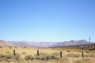
The Nevada Subdivision is a railway line in Nevada owned by the Union Pacific Railroad, as part of the Overland Route. It runs from Sparks to Weso, Nevada, east of Winnemucca. While part of the Overland Route, the line also serves to connect the Central Corridor to California via the Donner Pass route through the Sierra Nevada. The line was originally built as a segment of the first transcontinental railroad between June and November 1868. While primarily utilized for freight since 1971, the route is used by the once-daily Amtrak California Zephyr. As of 2003 the line hosts 14 freight trains per day.
The Fresno Subdivision is a railroad in California owned and operated by the Union Pacific Railroad. Mostly built by the Southern Pacific Railroad in the 1870s, the line traverses the San Joaquin Valley on a northwest to southeast alignment.

J.R. Davis Yard is a railway hump yard in Roseville, California owned by the Union Pacific Railroad. It is located along the confluence of three of the railroad's lines: the Martinez Subdivision heading southwest to the Sacramento Valley, the Roseville Subdivision which runs over the Sierra Nevada Mountains into Nevada, and the Valley Subdivision which heads north to Lincoln and Marysville. It takes its name from the last president of the Southern Pacific Transportation Company, Jerry R. Davis.
