Turó del Castell (Tavertet)

Last updated
Turó del Castell

Tavertet - Puig de la forca des de la via, sota Santa Cilia.jpg

Turó del Castell, Puig de la Força and the Susqueda dam
Highest point
Elevation 851 m (2,792 ft)
Listing Mountains in Catalonia
Coordinates 41°58′59.06″N2°23′46.65″E / 41.9830722°N 2.3962917°E / 41.9830722; 2.3962917
Geography
Location Osona, Catalonia
Parent range Guilleries
Climbing
Easiest route From Tavertet

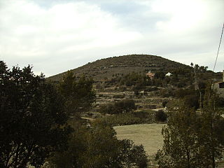
Turó del Castell is a mountain of the Guilleries Massif, Catalonia, Spain. It has an elevation of 851.1 metres above sea level. [1] The Susqueda reservoir lies off the southern slopes of the mountain. The high plateau lying ENE of the mountain is known as Pla del Castell. A rocky outcrop known as Puig de la Força (739 m) rises WSW of the summit.

Guilleries mountain in Spain

The Guilleries Massif is a mountain system located at the apex of the Catalan Transversal Range and the Pre-Coastal Range. The highest point of the range is Sant Miquel de Solterra or Sant Miquel de les Formigues, other main peaks are Turó del Faig Verd, Rocallarga, Sant Benet, El Far, Sant Gregori, Montdois, L'Agullola and Turó del Castell

Catalonia Autonomous area of northeastern Spain

Catalonia is an autonomous community in Spain on the northeastern corner of the Iberian Peninsula, designated as a nationality by its Statute of Autonomy. Catalonia consists of four provinces: Barcelona, Girona, Lleida, and Tarragona. The capital and largest city is Barcelona, the second-most populated municipality in Spain and the core of the sixth most populous urban area in the European Union. It comprises most of the territory of the former Principality of Catalonia. It is bordered by France (Occitanie) and Andorra to the north, the Mediterranean Sea to the east, and the Spanish autonomous communities of Aragon to the west and Valencia to the south. The official languages are Catalan, Spanish, and the Aranese dialect of Occitan.

Spain Kingdom in Southwest Europe

Spain, officially the Kingdom of Spain, is a country mostly located in Europe. Its continental European territory is situated on the Iberian Peninsula. Its territory also includes two archipelagoes: the Canary Islands off the coast of Africa, and the Balearic Islands in the Mediterranean Sea. The African enclaves of Ceuta, Melilla, and Peñón de Vélez de la Gomera make Spain the only European country to have a physical border with an African country (Morocco). Several small islands in the Alboran Sea are also part of Spanish territory. The country's mainland is bordered to the south and east by the Mediterranean Sea except for a small land boundary with Gibraltar; to the north and northeast by France, Andorra, and the Bay of Biscay; and to the west and northwest by Portugal and the Atlantic Ocean.

Related Research Articles

La Jonquera Municipality in Catalonia, Spain

La Jonquera is a municipality in the comarca of l'Alt Empordà, in Catalonia, Spain. It is situated next to the border with France, opposite the municipality of Le Perthus.

Palamós Municipality in Catalonia, Spain

Palamós is a town and municipality in the Mediterranean Costa Brava, located in the comarca of Baix Empordà, in the province of Girona, Catalonia, Spain.

Valls Municipality in Catalonia, Spain

Valls is the capital of the comarca of Alt Camp, in Catalonia, Spain. According to the 2014 census it has a population of 24,570.

Pallars Natural region

Pallars is a historical and natural region of Catalonia. Located in the Pre-Pyrenees and Pyrenees area, most of its territory is mountainous.

Lluís Domènech i Montaner Spanish architect and politician

Lluís Domènech i Montaner was a Spanish architect who was highly influential on Modernisme català, the Catalan Art Nouveau/Jugendstil movement. He was also a Catalan politician.

Olivella Municipality in Catalonia, Spain

Olivella is a municipality in Catalonia, in the province of Barcelona, Spain. It is situated in the comarca of Garraf.

Malgrat de Mar Municipality in Catalonia, Spain

Malgrat de Mar is a municipality in the comarca of the Maresme, in the province of Barcelona, Catalonia, Spain. It is situated on the Costa Brava between Santa Susanna and Blanes. A local road runs from the town to the main N-II road, while the B-682 connects it with Blanes, Lloret de Mar and Tossa de Mar. It is served by a RENFE railway station on the R1 line between Barcelona and Maçanet-Massanes.

Castell-Platja dAro Municipality in Catalonia, Spain

Castell-Platja d'Aro is a municipality in the middle of the Costa Brava in Catalonia, Spain. It is formed from two parts: Castell d'Aro is an ancient village built around a medieval castle and a fortified church, 3 km inland on the road from Platja d'Aro to Santa Cristina d'Aro; and Platja d'Aro is a coastal town on the road from Palamós to Sant Feliu de Guíxols which stretches along a large 2 km beach. Originally a small fishing village, Platja d'Aro is now a major coastal resort, popular predominantly with Catalans and villa-owning Northern Europeans.

C-31 highway (Spain)

C-31 or Eix Costaner is a Catalonia's primary highway. It is the result of merging several sections of previously existing roads, autopistas and autovías after the 2004's renaming of primary highways managed by the Generalitat de Catalunya. According to this new denomination, the first number (C-31) indicates that is a southwest-northeast highway, while the second number (C-31) indicates that is the closest to the Mediterranean Sea.

Ports de Tortosa-Beseit mountain

Ports de Tortosa-Beseit, also known as Ports de Beseit, or simply as Els Ports[əls ˈpɔɾts] or Lo Port[lu ˈpɔɾt] by locals, is a limestone mountain massif located at the north-eastern end of the Sistema Ibérico, a complex system of mountain ranges and massifs in the centre of the Iberian Peninsula. Its highest point is Mont Caro, 1,441 m. Rivers such as the Matarranya and the Sénia have their source in these mountains.

Castelltallat range mountain in Spain

The Castelltallat range is located in central Catalonia (Spain) between the counties of Bages and Solsonès, extending over the provinces of Barcelona and Lleida, and occupying an area of about 65 square kilometres. It is one of the isolated hills of the Catalan Central Depression and is located at its southwestern end.

Bellver de Cerdanya Municipality in Catalonia, Spain

Bellver de Cerdanya is a town in the comarca of Cerdanya, province of Lleida, Catalonia, Spain.

Muntanya de Santa Bàrbara mountain in Spain

Muntanya de Santa Bàrbara is a mountain that is part of the northwestern foothills of the Ports de Tortosa-Beseit, Catalonia, Spain. It has an elevation of 751.3 metres above sea level.

Serra de Pàndols mountain in Spain

Serra de Pàndols is a limestone mountain chain located at the southern end of the Catalan Pre-Coastal Range, in Catalonia, Spain.

Serra de Cavalls mountain in Spain

Serra de Cavalls is a mountain chain located at the southern end of the Catalan Pre-Coastal Range, Catalonia, Spain. The ridge's highest point is Punta Redona. This mountain range lies within the Benissanet, Gandesa and El Pinell de Brai municipal term. On the northern side are two ridges of parallel foothills called Serra del Pebre and Serra de Santa Madrona. Its northern prolongation is known as Serra de la Vall de la Torre.

Roques de Benet mountain in Spain

Roques de Benet is a compact group of sheer rocky outcrops in the northwestern side of the Ports de Tortosa-Beseit, Catalonia, Spain. The highest summit has an elevation of 1,017.1 metres above sea level.

Castell de lAirosa mountain in Spain

Castell de l'Airosa is a rocky mountain in the eastern side of the Ports de Tortosa-Beseit, Catalonia, Spain. Its summit has an altitude of 953.8 metres above sea level.

Joan Abella i Creus catalan mineralogist

Joan Abella i Creus is a Catalan gemmologist and mineralogist who discovered abellaite, a mineral that receives this name in his honor

References

  1. "Mapa Topogràfic de Catalunya". Institut Cartogràfic de Catalunya. Retrieved May 22, 2010..