Guilleries

Last updated
Guilleries

Sant Miquel de Solterra.jpg

Highest point
Elevation 1,202 m (3,944 ft)
Coordinates 41°56′34.93″N2°24′49.39″E / 41.9430361°N 2.4137194°E / 41.9430361; 2.4137194 Coordinates: 41°56′34.93″N2°24′49.39″E / 41.9430361°N 2.4137194°E / 41.9430361; 2.4137194
Geography
Location Selva, Catalonia
Parent range Catalan Pre-Coastal Range and Catalan Transversal Range
Geology
Mountain type Metamorphic rock
Climbing
Easiest route From Sant Hilari Sacalm or from Osor
Guilleries Massif location. Guilleries.svg
Guilleries Massif location.

The Guilleries Massif (Catalan Les Guilleries) is a mountain system located at the apex of the Catalan Transversal Range and the Pre-Coastal Range. The highest point of the range is Sant Miquel de Solterra or Sant Miquel de les Formigues (1.204 m), other main peaks are Turó del Faig Verd (1,187 m), Rocallarga (1,187 m), Sant Benet (1,149 m), El Far (1,111 m), Sant Gregori (1 ,094 m), Montdois (930 m), L'Agullola (921 m) and Turó del Castell (851 m) [1]

Catalan language Romance language

Catalan is a Western Romance language derived from Vulgar Latin and named after the medieval Principality of Catalonia, in northeastern modern Spain. It is the only official language of Andorra, and a co-official language of the Spanish autonomous communities of Catalonia, the Balearic Islands and Valencia. It also has semi-official status in the Italian commune of Alghero. It is also spoken in the eastern strip of Aragon, in some villages of Region of Murcia called Carche and in the Pyrénées-Orientales department of France. These territories are often called Països Catalans or "Catalan Countries".

Catalan Transversal Range

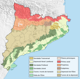
The Catalan Transversal Range is a system of minor mountain ranges at the eastern end of the Pre-Pyrenees, between the Osona and Garrotxa comarques. The existence of the Catalan Transversal Range has made communications in the northern areas of Catalonia difficult in the past, especially between Northeastern Catalonia and Western Catalonia, a problem that has been partly solved with the development of the Eix Transversal.

Catalan Pre-Coastal Range system of mountain ranges running parallel to the Mediterranean Sea coast in Catalonia

The Catalan Pre-Coastal Range is a system of mountain ranges running parallel to the Mediterranean Sea coast in Catalonia. It is part of the Catalan Mediterranean System. Its main axis runs between the Catalan Transversal Range and the Serra de l'Espina, which connects with the Ports de Tortosa-Beseit, part of the Iberian System. The highest point is 1.706,7 m at the Montseny Massif.

Contents

The Guilleries is one of the few places in the Catalan Mediterranean System where amphibolite facies conditions are found. [2] The Pantà de Susqueda and Pantà de Sau reservoirs, of great importance for Barcelona metropolitan water supply, are located in the Guilleries area.

Catalan Mediterranean System mountain in Spain

The Catalan Mediterranean System, also known as Mediterranean System, Transversal Ibero-Pyrenaean System, and Catalanid System, is a wide coastal geographical region in Catalonia. It is made up of a double system of coastal mountain chains: The Catalan Coastal Range and the Catalan Pre-Coastal Range, as well as the Catalan Coastal Depression and other coastal and pre-coastal plains located among those mountain ranges.

Amphibolite A metamorphic rock containing mainly amphibole and plagioclase

Amphibolite is a metamorphic rock that contains amphibole, especially the species hornblende and actinolite, as well as plagioclase.

Barcelona City and municipality in Catalonia, Spain

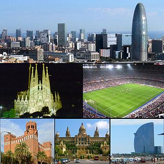
Barcelona is a city in Spain. It is the capital and largest city of the autonomous community of Catalonia, as well as the second most populous municipality of Spain. With a population of 1.6 million within city limits, its urban area extends to numerous neighbouring municipalities within the Province of Barcelona and is home to around 4.8 million people, making it the sixth most populous urban area in the European Union after Paris, London, Madrid, the Ruhr area and Milan. It is one of the largest metropolises on the Mediterranean Sea, located on the coast between the mouths of the rivers Llobregat and Besòs, and bounded to the west by the Serra de Collserola mountain range, the tallest peak of which is 512 metres high.

These mountains were notorious in former times for being a haunt of bandits and highwaymen. [3]

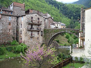
The main towns in the Guilleries area are Sant Hilari Sacalm, Osor, Susqueda, Vilanova de Sau, Sant Sadurní d'Osormort, Espinelves and Viladrau.

Sant Hilari Sacalm Municipality in Catalonia, Spain

Sant Hilari Sacalm is a municipality in the comarca of the Selva in Catalonia, Spain.

Osor, Girona Municipality in Catalonia, Spain

Osor is a municipality in the comarca of la Selva in Catalonia, Spain.

Susqueda Municipality in Catalonia, Spain

Susqueda is a municipality in the comarca of the Selva in Catalonia, Spain. It is located in the Guilleries Massif area, on the left bank of the Ter river in the north-west of the comarca. The Susqueda reservoir is on the municipal territory, and the associated hydroelectric power station is an important source of local income. A local road links the municipality with the C-152 road to Santa Coloma de Farners.

See also

Related Research Articles

Olot Municipality in Catalonia, Spain

Olot is the capital city of the comarca of Garrotxa, in the Province of Girona, Catalonia, Spain. The city is known for its natural landscape, including four volcanoes scattered around the city center. The municipality is part of the Garrotxa Volcanic Zone Natural Park. Olot is also well known for its cultural activity, with historical art movements like Olot school or factories of religious imagery, which contributed to the location in the city of the main Design and Arts & Crafts school of the province of Girona, the Escola d'Art i Superior de Disseny d'Olot.

Vilanova de Sau Municipality in Catalonia, Spain

Vilanova de Sau is a town in the comarca of the Osona in Catalonia, eastern Spain. It is situated in the valley called Sau. The Ter river runs through the valley, now damed into Pantà de Sau, a reservoir which is in the municipal territory of Vilanova de Sau, and is a tourist attraction and base for water sports and hiking. The reservoir houses the submerged village of church of Sant Romà.

Montseny Massif mountain

Montseny is a mountain range west of the coastal hills north of Barcelona. It is part of the Catalan Pre-Coastal Range.

Rupit human settlement in Spain

Rupit is a village in the county of Osona, in the subregion of the Collsacabra, in Catalonia, Spain. It is located at 822 m above sea level, 98 km from Barcelona.

Sant Miquel de Solterra mountain in Spain

Sant Miquel de Solterra or Sant Miquel de les Formigues is the highest mountain of the Guilleries Massif, Catalonia, Spain. It has an elevation of 1,201.9 metres above sea level.

Sant Roc, also known as Sant Roc d'Amer, Sant Roc de la Barroca and Grony, is a mountain of the Catalan Transversal Range, Catalonia, Spain. It has an elevation of 591 metres above sea level. It is part of the range that separates the Llémena River and the Brugent river valleys and is located at the confluence of the Garrotxa, el Gironès and la Selva comarques. This mountain has a striking appearance and is quite visible from the road between Bonmatí and Sant Martí de Llémena. The steep cliffs on the southern and northeastern sides of the mountain are known as Cingles de Sant Roc.

Sub-Pyrenees

The Sub-Pyrenees are a mountainous region in Catalonia, Spain, forming a section of the southern foothills of the Pyrenees. They are located at the eastern end of the Pre-Pyrenees, west of the Catalan Transversal Range, between the lower Ripollès and an area of the high Garrotxa.

Plain of Vic Natural region in Catalonia, Spain

The Plain of Vic is a 30 km long depression located at the eastern end of the Catalan Central Depression in the Osona comarca. It is named after the town of Vic, an important and ancient urban center in this natural region that lies in the midst of the plain. Other significant towns in the plain are Manlleu and Tona.

Serra de Pàndols mountain in Spain

Serra de Pàndols is a limestone mountain chain located at the southern end of the Catalan Pre-Coastal Range, in Catalonia, Spain.

Serra de Cavalls mountain in Spain

Serra de Cavalls is a mountain chain located at the southern end of the Catalan Pre-Coastal Range, Catalonia, Spain. The ridge's highest point is Punta Redona. This mountain range lies within the Benissanet, Gandesa and El Pinell de Brai municipal term. On the northern side are two ridges of parallel foothills called Serra del Pebre and Serra de Santa Madrona. Its northern prolongation is known as Serra de la Vall de la Torre.

Catalan Central Depression

The Catalan Central Depression is a natural depression between the Pre-Pyrenees and the Catalan Pre-Coastal Range in Spain. It widens towards the west, linking with the Ebro Depression, Catalan: Depressió de l'Ebre, of which it could be considered an eastern extension. The Catalan Central Depression is about 180 km long with an average width of 50 km.

Turó de la Mamella mountain in Spain

Turó de la Mamella is a mountain of Catalonia, Spain. Located in the Terrassa and Vacarisses municipal limits, it is one of the foothills of the Serra de l'Obac, Catalan Pre-Coastal Range, and has an elevation of 806.6 metres above sea level.

Prades Mountains mountain in Spain

Prades Mountains, also known as Muntanyes de Prades, is a large calcareous mountain massif straddling the comarcas of Alt Camp, Baix Camp, Conca de Barberà, Garrigues and Priorat, in Catalonia, Spain. They are a Site of Community Importance.

Alforja Municipality in Catalonia, Spain

Alforja is a municipality in the comarca of Baix Camp, in the province of Tarragona, Catalonia, Spain.

Susqueda Reservoir lake in Girona Province, Spain

Susqueda Reservoir is a reservoir located on the Ter river, near Osor, Catalonia, Spain. The dam is located in Osor while the main water body is within the boundaries of Susqueda and Sant Hilari Sacalm. The construction of the dam was completed in 1968, creating a reservoir with a storage capacity of 233 hm³ that covered the old villages of Susqueda and Querós. The dam has a structural height of 135 m and a crest length of 360 m.

Sant Miquel del Fai cultural property in Bigas, Spain

Sant Miquel del Fai is a cenobitic Benedictine monastery in Bigues i Riells, Catalonia, Spain. The 11th-century building was declared a Bien de Interés Cultural landmark in 1988.

References