Finnmark was a county in the northern part of Norway. On 1 January 2020, Finnmark was merged with the neighbouring county of Troms to form the new Troms og Finnmark county; however, on 1 January 2024, the county will be demerged back to the counties Finnmark and Troms; parliament decided that on 15 June 2022.

Kautokeino is a municipality in Troms og Finnmark county, Norway. The administrative centre of the municipality is the village of Guovdageaidnu/Kautokeino. Other villages include Láhpoluoppal and Máze.
Alta is the most populated municipality in Finnmark in Troms og Finnmark county, Norway. The administrative centre of the municipality is the town of Alta. Some of the main villages in the municipality include Kåfjord, Komagfjord, Kvenvik, Langfjordbotn, Leirbotn, Rafsbotn, Talvik, and Tverrelvdalen.

Jondal is a former municipality in the old Hordaland county, Norway. The 247-square-kilometre (95 sq mi) municipality existed from 1863 until its dissolution in 2020 when it became part of Ullensvang Municipality in Vestland county. It was located on the Folgefonna peninsula in the Hardanger district, on the eastern shore of the Hardangerfjorden. The administrative centre of the municipality was the village of Jondal. Other villages in Jondal include Herand, Kysnesstranda, and Torsnes.

Stryn is a municipality in the county of Vestland, Norway. It is located in the traditional district of Nordfjord. The administrative center of the municipality is the village of Stryn. The municipality is located along the innermost part of the Nordfjorden. Some of the main villages in Stryn include Loen, Innvik, Utvik, Randabygda, Olden, and Flo.
Åndalsnes (help·info) is a town in Rauma Municipality in Møre og Romsdal county, Norway. Åndalsnes is in the administrative center of Rauma Municipality. It is located along the Isfjorden, at the mouth of the river Rauma, at the north end of the Romsdalen valley. The village of Isfjorden lies about 7 kilometres (4.3 mi) to the east, Veblungsnes lies just to the west across the Rauma, and Innfjorden lies about 10 kilometres (6.2 mi) to the southwest via the European Route E136 highway.

Lakselv (help·info) is the largest village and administrative centre of Porsanger Municipality in Troms og Finnmark county, Norway. The village lies at the southern end of the large Porsangerfjorden. The 2.3-square-kilometre (570-acre) village has a population (2017) of 2,283 which gives the village a population density of 993 inhabitants per square kilometre (2,570/sq mi).

Øvre Årdal is a village in Årdal Municipality in Vestland county, Norway. It is the larger of the two primary villages in Årdal. The village is situated at the northern end of the 9-kilometre (5.6 mi) long lake Årdalsvatnet, with the village of Årdalstangen at the southern end. The 1.81-square-kilometre (450-acre) village has a population (2019) of 3,117 and a population density of 1,722 inhabitants per square kilometre (4,460/sq mi).

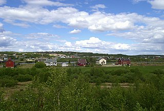
Rafsbotn (Norwegian) or Rässivuono (Kven) is a village in Alta Municipality in Troms og Finnmark county, Norway. The village sits at the southeast end of the Altafjorden, along the European route E6 highway, about 12 kilometres (7.5 mi) northeast of the town of Alta. The name comes from the Sami place name Ráššvuotna which means a clay seabed. The 0.34-square-kilometre (84-acre) village has a population (2017) of 408 which gives the village a population density of 1,200 inhabitants per square kilometre (3,100/sq mi). Rafsbotn has a ski slope and Rafsbotn Chapel.
Sørkjosen is a village in Nordreisa Municipality in Troms og Finnmark county, Norway. The village is located along the shores of the Reisafjorden about 5 kilometres (3.1 mi) northwest of the municipal center of Storslett. Sørkjosen has many industries including fishing, dairy production, and a sawmill.

Byglandsfjord is a village in Bygland municipality in Agder county, Norway. The village is located in the Setesdal valley along the Norwegian National Road 9 and the river Otra in the far southern part of the municipality, just north of the border with Evje og Hornnes municipality and at the southern end of the lake Byglandsfjorden. The 0.47-square-kilometre (120-acre) village has a population (2016) of 365 which gives the village a population density of 777 inhabitants per square kilometre (2,010/sq mi). Revsnes Hotel offers accommodation.
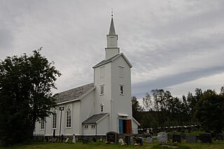
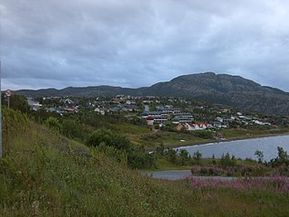
Talvik is a village in Alta Municipality in Finnmark county in Norway. It is located on the western shore of the Altafjorden, along the European route E6 highway. The village is an old trading centre since the 1800s. Talvik Church is located in the village.

Iešjávri is a large lake on the border of the three municipalities of Alta, Kautokeino, and Karasjok in Troms og Finnmark county, Norway. The lake lies on the Finnmarksvidda plateau about 50 kilometres (31 mi) northwest of the village of Karasjok, about 30 kilometres (19 mi) northeast of the village of Masi, and about 45 kilometres (28 mi) southeast of the town of Alta.
Birtavarre is a village in the municipality of Gáivuotna-Kåfjord-Kaivuono in Troms og Finnmark county, Norway. The village is located along the Kåfjordelva river at the end of the Kåfjorden in the Kåfjorddalen valley in an area called Kåfjordbotn.
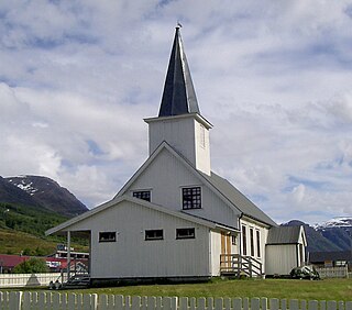
Støren (help·info) is the administrative centre of Midtre Gauldal municipality in Trøndelag county, Norway. The village is located in the Gauldalen valley at the confluence of the rivers Gaula and Sokna. Støren is located on the European route E06 highway, about 50 kilometres (31 mi) south of the city of Trondheim. The junction between the Dovrebanen and Rørosbanen railway lines is at Støren Station in the northern part of the village. Støren Church, a school, government services, and commercial and industrial sites are all located in the village.
Alta-Talvik is a former municipality in Finnmark county, Norway. The 3,849-square-kilometre (1,486 sq mi) municipality existed from 1838 until its dissolution in 1863. It was located along the Altafjorden and the river Altaelva with the same borders as the present-day Alta Municipality. The administrative centre was the village of Alta. The European route E6 highway runs through the area today.
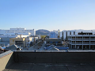
Alta is a town in Alta Municipality in Troms og Finnmark county, Norway. The town is the administrative centre of the municipality and the major commercial centre in the western part of the county. The town is located on the southern end of Altafjorden at the mouth of the river Altaelva. There are several suburbs around the town. Kåfjord, Kvenvik, and Jiepmaluokta lie to the west; Øvre Alta and Tverrelvdalen lie to the south; and Rafsbotn lies to the east. The famous rock carvings at Alta lie just to the west of the town.
Kautokeino is the administrative centre of Kautokeino Municipality in Troms og Finnmark county, Norway. The village is located along the river Kautokeinoelva, about 60 kilometres (37 mi) south of the village of Masi and about 40 kilometres (25 mi) north of the Finland–Norway border.
Vennesla is the administrative centre of Vennesla municipality in Agder county, Norway. The village is located in the upper Torridal valley along the river Otra, about 15 kilometres (9.3 mi) north of the city of Kristiansand. The village itself extends for about 10 kilometres (6.2 mi) along both sides of the river. The Norwegian National Road 9 passes through Mosby, about 6 kilometres (3.7 mi) south of Vennesla. The Sørlandsbanen railway line passes through Vennesla, stopping at Vennesla Station. The lake Venneslafjorden is located on the river Otra in the northern part of the village of Vennesla.
Meldal is a village and former municipality. It is now part of the municipality of Orkland in Trøndelag county, Norway. Prior to the creation of the Orkland municipality it was the administrative centre of the Meldal municipality. The village is located in the Orkdalen valley, along the river Orkla. The village of Å lies about 8 kilometres (5.0 mi) to the south, the village of Løkken Verk lies about 10 kilometres (6.2 mi) to the north, and the village of Storås lies about 8 kilometres (5.0 mi) to the northwest.