
A tarn is a mountain lake, pond or pool, formed in a cirque excavated by a glacier. A moraine may form a natural dam below a tarn.

Hempstead Lake State Park is a 737-acre (2.98 km2) state park located in Nassau County, New York in the United States. The park is located in West Hempstead and is one of three state parks within the Town of Hempstead. There is a quick-access entrance at exit 18 from the Southern State Parkway. The park contains the largest freshwater lake in Nassau County.

Grafton Lakes State Park is a 2,545-acre (10.30 km2) state park located in Rensselaer County, New York, United States. The park is in the central part of the Town of Grafton and north of the hamlet of Grafton on NY Route 2, northeast of Albany. The park contains the Shaver Pond Nature Center.

The Saint Regis Canoe Area in Adirondack Park is the largest wilderness canoe area in the Northeastern United States and the only designated canoe area in New York state. It is closed to motorized vehicles. Among the 58 ponds and lakes are Upper Saint Regis Lake, part of the Seven Carries route, and Saint Regis Pond. It contains the headwaters of the West and Middle Branch of the Saint Regis and the Saranac Rivers. Only two of the lakes can be reached without a portage, or carry as it is known in the region. Primitive canoe camping is permitted on many of the lakes and ponds. Saint Regis Mountain and Long Pond Mountain are within the area.
Narrows Pond is actually two small twin lakes in Winthrop, Maine. They are Upper and Lower Narrows Pond, and are divided by a very narrow isthmus, hence the name. The isthmus is traversed by Narrows Pond Road, and a culvert connects the two lakes. People in canoes or kayaks can travel between the two lakes, though only by ducking first.
Little Sunapee Lake is a 486-acre (197 ha) water body located primarily in Merrimack County in central New Hampshire, United States, in the town of New London. A small portion of the lake crosses into neighboring Springfield in Sullivan County. The lake is sometimes referred to as "Twin Lakes" due to a long, narrow peninsula which nearly cuts the lake in half. Water flowing out of the lake passes through Goose Pond and Otter Pond before entering Lake Sunapee. Bucklin Beach is a Town of New London recreation area at the east end of the lake.

Kittatinny Valley State Park is located near Andover, New Jersey. Features include Glacial lakes, limestone outcroppings, former railroads, and a small airport. Lake Aeroflex and Gardner's Pond form part of the headwaters of the Pequest River and are excellent for fishing and boating. The park is home to a variety of wildlife such as whitetail deer, wild turkeys, a variety of songbirds, beavers, muskrats, and squirrels. The park is operated and maintained by the New Jersey Division of Parks and Forestry.
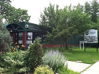
Alley Pond Park is the second-largest public park in Queens, New York City, occupying 655.3 acres (265.2 ha). The park is bordered to the east by Douglaston, to the west by Bayside, to the north by Little Neck Bay, and to the south by Union Turnpike. Cross Island Parkway travels north-south through the park, while the Long Island Expressway and Grand Central Parkway travel east-west through the park. The park primarily consists of woodlands south of the Long Island Expressway and meadowlands north of the expressway. It is run and operated by the New York City Department of Parks and Recreation.

Sandy Island Beach State Park is a New York State park on the eastern shore of Lake Ontario. Its highlight is a 1,500-foot (460 m) natural sandy beach. The park is near the southern end of a notable 17-mile (27 km) length of sandy shoreline, coastal dunes, and wetlands ; a 1959 study noted that "The eastern end of Lake Ontario contains not only the finest beaches on the entire lake but also the finest wildlife habitat."
Monponsett Pond, also called Monponsett Lake and the Twin Lakes, originally one lake is dissected by route 58 into a system of two ponds, West and East, mostly in Halifax, Massachusetts, with a small portion of West Monponsett Pond extending into Hanson. The western basin is 282 acres (1.14 km2), and the eastern basin is 246 acres (1.00 km2). The average depth of both ponds is seven feet and the maximum depth is 13 feet (4.0 m). The outflow is Stump Brook, a tributary of Poor Meadow Brook, in the northwestern part of West Monponsett Pond. The pond is part of the Taunton River Watershed. Occasionally during water shortages water from this pond is diverted into Silver Lake, the principal water supply for the City of Brockton.
Holy Mount, 1,968 feet (600 m), is a prominent peak in the Taconic Mountains of western Massachusetts, formerly used as the location of religious ceremonies by a nearby Shaker community.

The Moose River Plains Wild Forest is a 64,322-acre tract in the Adirondack Park in Hamilton and Herkimer counties in the state of New York in the United States of America; it is designated as Wild Forest by the New York State Department of Environmental Conservation.

Black Pond Wildlife Management Area is a 526-acre (213 ha) New York State Wildlife Management Area (WMA) that lies on the eastern shore of Lake Ontario, and at the northern limit of an unusual region of sandy barrier beaches and lagoons. Much of the barrier beach in Black Pond WMA has forested sand dunes that are about 60 feet (18 m) high; these are the highest sand dunes in the northeast United States excepting Cape Cod. Immediately north of the WMA is the 360-acre (150 ha) El Dorado Beach Preserve, which is a bird refuge owned by The Nature Conservancy. North of the outlet from Black Pond to Lake Ontario, the shoreline is a weathered, flat bedrock shelf that is "calcareous" instead of sandy.
Thompson Pond in Pine Plains, New York is a 75-acre (30 ha) 15,000-year-old glacial kettle pond at the foot of 1,403-foot (428 m) Stissing Mountain. It is the source of Wappinger Creek, a tributary of the Hudson River that drains much of Dutchess County.

Enchanted Pond is a mountain pond in the U.S. state of Maine. Situated in the Western Maine Mountains in the Northwest Somerset Region, the pond is located in a deep mountain valley between Coburn Mountain and Shutdown Mountain. Near its southern end, the pond is distinguished by two rockslides from the exposed cliffs of these mountains that extend down into the water along both shores. Enchanted Pond is fed by mountain springs and Little Enchanted Pond, and is the primary source of Enchanted Stream which flows into the Dead River, a tributary of the Kennebec River. Development on the pond is limited to a small set of sporting camps at the northern end of the pond and one remote camp on the southwest shore, both a part of Bulldog Camps. There are no islands in the pond.

Cedar Lake is located northwest of Sled Harbor, New York. Fish species present in the lake are brook trout, black bullhead, and white sucker. There is trail access on the north and west shores from Sled Harbor. There is also trail access to Whitney Lake. No motors are allowed on this lake.

Lake of the Twin Fawns also called "Duck Pond" is a small lake in Otsego County, New York. It is located northwest of Laurens within Gilbert Lake State Park. Lake of the Twin Fawns either drains west via an unnamed creek which flows into Stony Creek or south via Lake Brook which flows into Gilbert Lake.
