Tyldesley Urban District

Last updated
Tyldesley Urban District
Tyldesley Town Hall.jpg
Tyldesley Town Hall
Area
  18942,690 acres (10.9 km2)
  19745,375 acres (21.75 km2)
Population
  191115,582
  196116,813
History
  Created1894
  Abolished1974
  Succeeded by Metropolitan Borough of Wigan
Status Urban district
   HQ Tyldesley Town Hall

Tyldesley cum Shakerley Urban District and its successor Tyldesley Urban District was, from 1894 to 1974, a local government district in Lancashire, England.

Contents

History

The township of Tyldesley cum Shakerley historically lay in the large ecclesiastical parish of Leigh and was a member of the Leigh Poor Law Union which was formed in 1837. [1] [2]

In 1863 Tyldesley cum Shakerley Local Government District was created when the township adopted the Local Government Act 1858. A local board was formed to govern the town. The Local Government Act 1894 reconstituted the area as an urban district, and Tyldesley cum Shakerley Urban District Council replaced the local board. The urban district council consisted of fifteen members, representing five wards—North, East, South, West, and Shakerley. [3] The only change to boundaries was in 1933, when the Lancashire (Manchester and District) Review Order added Astley civil parish from the neighbouring Leigh Rural District and the urban district was renamed Tyldesley Urban District. [4] In 1974 Tyldesley Urban District was abolished by the Local Government Act 1972 and its former area transferred to Greater Manchester to form part of the Metropolitan Borough of Wigan.

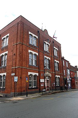
Tyldesley's town hall was originally in Lower Elliot Street, opposite the council's depot and fire station. In 1924 the township's Liberal Club which opened in 1881 was bought by the council as its town hall. Tyldesley UDC was responsible for the opening of Tyldesley Park on Astley Street in 1902, [5] the provision of the Carnegie Library in 1909, and council housing estates at Sale Lane, Mosley Common and Shakerley.

Related Research Articles

Leigh, Greater Manchester Town in Greater Manchester

Leigh is a town in the Metropolitan Borough of Wigan, Greater Manchester, England, 7.7 miles (12 km) southeast of Wigan and 9.7 miles (15.6 km) west of Salford, on low-lying land northwest of Chat Moss.

Metropolitan Borough of Wigan Metropolitan borough in England

The Metropolitan Borough of Wigan is a metropolitan borough of Greater Manchester, in North West England. It is named after the former county borough and includes the towns and villages of Wigan, Leigh, part of Ashton-in-Makerfield, Abram, Ince-in-Makerfield, Hindley, Orrell, Standish, Atherton, Tyldesley, Golborne, Lowton, part of Billinge, Astley, Haigh and Aspull. The borough was formed in 1974 and is an amalgamation of several former local government districts and parishes. The borough has three civil parishes and lies directly to the west of the City of Salford and southwest of the Metropolitan Borough of Bolton. The local authority is Wigan Metropolitan Borough Council.

Atherton, Greater Manchester Human settlement in England

Atherton is a town in the Metropolitan Borough of Wigan, in Greater Manchester, England and historically a part of Lancashire. The town, including Hindsford, Howe Bridge and Hag Fold, is 5 miles (8.0 km) east of Wigan, 2 miles (3.2 km) north of Leigh, and 10.7 miles (17.2 km) northwest of Manchester. From the 17th century, for about 300 years, Atherton was known as Chowbent, which was frequently shortened to Bent, the town's old nickname.

Astley, Greater Manchester Human settlement in England

Astley is a village in the Metropolitan Borough of Wigan, in Greater Manchester, England. Historically in Lancashire, it is crossed by the Bridgewater Canal and the A580 East Lancashire Road. Continuous with Tyldesley, it is equidistant from Wigan and Manchester, both 8.3 miles (13.4 km) away. The Astley Mosley Common ward had a population of 11,270 at the 2011 Census.

Tyldesley Human settlement in England

Tyldesley is a town in the Metropolitan Borough of Wigan in Greater Manchester, England, but historically in Lancashire. It is north of Chat Moss near the foothills of the West Pennine Moors, 7.7 miles (12.4 km) southeast of Wigan and 8.9 miles (14.3 km) northwest of Manchester. At the United Kingdom Census 2001, the Tyldesley built-up area, excluding Shakerley, had a population of 16,142.

Municipal Borough of Leigh

The Municipal Borough of Leigh was, from 1899 to 1974, a local government district of the administrative county of Lancashire, England, consisting of the townships of Pennington, Westleigh, Bedford and part of the township of Atherton and named after the ancient ecclesiastical parish. The area contained the market town of Leigh that served as its administrative centre until its dissolution in 1974. The borough council built Leigh Town Hall which was completed in 1907.

Royton Urban District

Royton was a local government district from 1863 to 1974 in Lancashire, England, which covered the modern-day town of Royton, and its suburbs and districts.

Mosley Common Human settlement in England

Mosley Common is a suburb of Tyldesley at the far-eastern edge of the Metropolitan Borough of Wigan, in Greater Manchester, England. Historically part of Lancashire, it was anciently a hamlet in the east of the township of Tyldesley cum Shakerley, in the ancient parish of Leigh. The area of Mosley Common in 1747 was 34 acres (14 ha) statute s.

Shakerley Human settlement in England

Shakerley is a suburb of Tyldesley in the Metropolitan Borough of Wigan, Greater Manchester, England. It was anciently a hamlet in the northwest of the township of Tyldesley cum Shakerley, in the ancient parish of Leigh. The boundary between Shakerley and Hindsford is the Hindsford Brook. It remains the boundary between Tyldesley and Atherton. Hyndforth Bridge across the brook, was rebuilt in stone in 1629.

St Georges Church, Tyldesley Church in Greater Manchester, England

St George's Church is an Anglican parish church serving Tyldesley and Shakerley in Greater Manchester, England. It is part of Leigh deanery in the archdeaconry of Salford and the diocese of Manchester. The church, together with St Stephen's Church, Astley and St John's Church, Mosley Common is part of the united benefice of Astley, Tyldesley and Mosley Common.

Atherton Urban District

Atherton was, from 1863 to 1974, a local government district in Lancashire, England.

Tyldesley Coal Company was a coal mining company formed in 1870 in Tyldesley, on the Manchester Coalfield in the historic county of Lancashire, England that had its origins in Yew Tree Colliery, the location for a mining disaster that killed 25 men and boys in 1858.

Ramsden's Shakerley Collieries was a coal mining company operating the Nelson and Wellington Pits from the mid 19th century in Shakerley, Tyldesley in the historic county of Lancashire, England.

Bedford, Greater Manchester

Bedford, a suburb of Leigh, Greater Manchester is one of three ancient townships, Bedford, Pennington and Westleigh, that merged in 1875 to form the town of Leigh. Historically, Bedford was in Lancashire.

Pennington, Greater Manchester

Pennington, a suburb of Leigh, Greater Manchester is one of six townships in the ancient ecclesiastical parish of Leigh, that with Westleigh and Bedford merged to form the town of Leigh in 1875. The township of Pennington covered most of Leigh's town centre.

Leigh Union workhouse, also known as the Leigh workhouse and after 1930, Atherleigh Hospital, was a workhouse built in 1850 by the Leigh Poor Law Union on Leigh Road, Atherton in the historic county of Lancashire.

St Stephens Church, Astley Church in Greater Manchester., England

St Stephen's Church is a parish church in Astley, Greater Manchester, England. It is an active Anglican church built in 1968 and part of Leigh deanery in the archdeaconry of Salford and diocese of Manchester. The church, together with St George's Church, Tyldesley and St John's Church, Mosley Common is part of the united benefice of Astley, Tyldesley and Mosley Common. Its origins are in Astley Chapel, a chapel of ease of Leigh Parish Church built in 1631 and its successor which was burned in an arson attack in 1961.

Tyldesley Town Hall

Tyldesley Town Hall is a municipal building in Elliott Street, Tyldesley, Greater Manchester, England. Initially the local Liberal Party Club, the town hall went on to become the meeting place of Tyldesley Urban District Council.

References

Citations

  1. Greater Manchester Gazetteer, Greater Manchester County Record Office, Place Names T to W, archived from the original on 18 July 2011, retrieved 7 March 2010
  2. Leigh, workhouses.org.uk, archived from the original on 5 June 2011, retrieved 3 April 2010
  3. Farrer, William; Brownbill, J (editors) (1907), "Tyldesley with Shakerley", A History of the County of Lancaster, Volume 3, Victoria County History, pp. 439–445, retrieved 7 March 2010CS1 maint: extra text: authors list (link)
  4. Great Britain Historical GIS Project (2004), "Tyldesley UD through time. Census tables with data for the Local Government District", A vision of Britain through time, University of Portsmouth, archived from the original on 4 June 2011, retrieved 7 March 2010
  5. Lunn (1953), p. 148.

Bibliography

Coordinates: 53°31′00″N2°28′00″W / 53.5166°N 2.4668°W / 53.5166; -2.4668