Tzrifin

Last updated • 5 min readFrom Wikipedia, The Free Encyclopedia
Jaffa gate of Tzrifin Jaffa gate in Tzrifin (Yadin) camp.jpg
Jaffa gate of Tzrifin

Tzrifin (Hebrew : צְרִיפִין) is an area in Gush Dan (Dan Region) in central Israel, located on the eastern side of Rishon LeZion and including parts of Be'er Ya'akov. The area proper is defined as an 'area without jurisdiction' between the two cities.

Contents

Nearly the entire area of Tzrifin proper was taken up by the central Israel Defense Forces (IDF) base, Camp Yigael Yadin (a.k.a. Camp Tzrifin, Camp 782), with which it is synonymous, even though the base also spills into Rishon LeZion and Be'er Ya'akov. Camp Yadin contains a multitude of training bases, as well as Prison Four, the largest Israeli military prison.

In late 2010s it was decided to vacate the area, move its bases to Camp Ariel Sharon in the South and repurpose the land for residential development.

Etymology

Tzrifin is a hebrew form of Sarafend (Ṣarafand / صرفند), an Arabic rendition of the Phoenician place-name *Ṣrpt. [1]

History

Sarafand, 19 May 1948 TSrypyn srpnd kybvSH hbsys 1948 1 TSlm bnv rvtnbrg gnzk hmdynh.jpg
Sarafand, 19 May 1948
Sarafand, 19 May 1948 TSrypyn srpnd kybvSH hbsys 1948 2 TSlm bnv rvtnbrg gnzk hmdynh.jpg
Sarafand, 19 May 1948

During the 18th and 19th centuries, the area of Tzrifin belonged to the Nahiyeh (sub-district) of Lod that encompassed the area of the present-day city of Modi'in-Maccabim-Re'ut in the south to the present-day city of El'ad in the north, and from the foothills in the east, through the Lod Valley to the outskirts of Jaffa in the west. This area was home to thousands of inhabitants in about 20 villages, who had at their disposal tens of thousands of hectares of prime agricultural land. [2]

Tzrifin was founded in 1917, during World War I, as a British base named Sarafand or Sarafend, after the nearby Arab village Sarafand al-Amar. Sarafand was a central British base in a strategic location situated nearby the important railway junction at Lydda (Lod) – which was accessible from the base via a spur off of the Jaffa–Lydda–Jerusalem railway. The Transjordan Frontier Force (TJFF) was established at Sarafand on 1 April 1926 with a cadre drawn from the Arab Legion. The TJFF subsequently moved to Zerqa in October 1926. During World War II, the Jewish Brigade was formed in Tzrifin. [3]

Starting in the 1930s, next to the military camp there was a concentration camp for Arab and Jewish Palestinian convicts in administrative detention, and for Jewish illegal immigrants. [4] [5]

On 14 May 1948, the day of the Israeli declaration of independence, British forces vacated Sarafand. False rumours suggested the British sold the base to the Arabs, but only Arab residents of nearby villages, some of whom worked in the base, entered the base for looting. [6] The adjacent Arab village Sarafand al-'Amr was depopulated on 15 May. After a two-day battle, between the 18th and 19 May, the base was captured by the Jewish forces from the Givati Brigade. [7] The place was named Tzrifin after a historical city with that name located in the area and mentioned in the Talmud. [8]

As the years passed, Rishon LeZion expanded to the east, eventually reaching the fence line of Camp Yadin. As a result, the IDF decided to vacate Tzrifin and sell its land to private residential developers due to the high land value. By the early 2020s the IDF is expected to vacate all of its installations from Tzrifin, with most of their functions being relocated to new bases to Camp Ariel Sharon in the Negev desert, Southern Israel.[ citation needed ] In 2019 the central part of the camp was demolished to give way for 1,100 new apartments for Rishon LeZion. [9]

Location and geography

Tzrifin is located between Rishon LeZion on the west, and Be'er Ya'akov on all 3 other sides. It is 72 m (236 ft) above sea level and 15 km (9.3 mi) from the Mediterranean seashore. [3] The base in it has three main entrances—Jaffa Gate, Jerusalem Gate and Rishon LeZion Gate, all of which are located within the municipalities, and not within Tzrifin proper.

The Jaffa Gate links a street within the base to Road 44 (Tzrifin Junction). At this location, there are a number of fast food restaurants and a pedestrian bridge which connects the base to the bus terminal on the other side of the road. The Assaf HaRofeh Medical Center is located near the Jaffa Gate.

The Jerusalem Gate links the base to Tzahal Road (Road 4313) in Be'er Ya'akov, which ultimately connects to Road 44 at the Nir Tzvi Junction in the Emek Lod Regional Council. The Rishon LeZion gate is located deep within Rishon LeZion and connects Rishon's Jerusalem Street with the base.

Bases

As with many other IDF bases, Camp Yadin is a container base for many smaller ones. The following is a list of bases within Camp Yadin.

Training bases

Other bases (partial links)

Non-military use

During the 1950s, a Ma'abara was located on the lands of Tzrifin, the residents of which eventually moved out to the nearby towns, especially Lod.

Currently, several non-military installations are located in the Tzrifin area:

Military evacuation and civilian development

The Israel Defense Forces is slated to move most bases in Tzrifin in 2013–2014 to the new City of Training Bases being built south of Beersheba. The area of the base will open to civilian development, and will be divided between the municipalities of Rishon LeZion and Be'er Ya'akov. Most of the area, 840 dunams (0.84 km2), will go Rishon LeZion, and much of it will be zoned for commercial development. This will including an industrial zone for medical development, next to the Asaf HaRofe Hospital. Be'er Ya'akov will get 560 dunams (0.56 km2) mostly for residential development. [10]

Archaeology

An archaeological excavation was conducted at Khirbet Tzrifin in 2010 by Ron Toueg on behalf of Israel Antiquities Authority (IAA). [11]

Related Research Articles

<span class="mw-page-title-main">Rishon LeZion</span> City in Israel

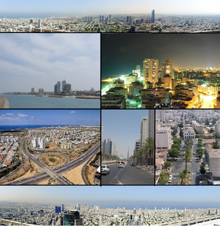
Rishon LeZion is a city in Israel, located along the central Israeli coastal plain eight kilometres (5 mi) south of Tel Aviv. It is part of the Gush Dan metropolitan area.

<span class="mw-page-title-main">Gush Dan</span> Metropolitan area in Israel

Gush Dan or Tel Aviv metropolitan area is a conurbation in Israel, located along the country's Mediterranean coastline. There is no single formal definition of Gush Dan, though the term is in frequent use by both governmental bodies and the general public. It ranges from combining Tel Aviv with cities that form an urban continuum with it, to the entire areas from both the Tel Aviv District and the Central District, or sometimes the whole Metropolitan Area of Tel Aviv, which includes a small part of the Southern District as well. Gush Dan is the largest conurbation and metropolitan area in Israel and the center of Israel's financial and High technology sector. The metropolitan area having an estimated population of 4,156,900 residents, 89% of whom are Israeli Jews.

<span class="mw-page-title-main">Lod</span> City in Israel

Lod, also known as Lydda and Lidd, is a city 15 km southeast of Tel Aviv and 40 km (25 mi) northwest of Jerusalem in the Central District of Israel. It is situated between the lower Shephelah on the east and the coastal plain on the west. The city had a population of 85,351 in 2019.

<span class="mw-page-title-main">Ness Ziona</span> City in Central District, Israel

Ness Ziona is a city in Central District, Israel. In 2022 it had a population of 50,341, and its jurisdiction was 15,579 dunams (15.579 km2 [6.015 sq mi]).

<span class="mw-page-title-main">Tel HaShomer</span> Neighborhood of Ramat Gan in Ramat Gan, Israel

Tel HaShomer or Kiryat Krinitzi is a neighborhood in Ramat Gan, Israel. It borders Kiryat Ono in the north, Yehud in the east, and Or Yehuda in the south. A major Israel Defense Forces base and the Sheba Medical Center are located in Tel HaShomer.

<span class="mw-page-title-main">Be'er Ya'akov</span> City in Israel

Be'er Ya'akov is a city in central Israel, near Ness Ziona and Rishon Lezion. The town has an area of 8,580 dunams (~8.6 km2), and had a population of 31,325 in 2022.

<span class="mw-page-title-main">Military Police Corps (Israel)</span> Military police of the State of Israel

The Military Police Corps of the Israel Defense Forces (Hebrew: חֵיל הַמִּשְׁטָרָה הַצְּבָאִית, Cheyl HaMishtara HaTzva'it, commonly called "Mem Tzadik" or "Mem Tzadi", is the Israeli military police and provost. The military police serves the Manpower Directorate during peacetime, and the Technological and Logistics Directorate during war.

Bahad is a military training base in the Israel Defense Forces. Each Bahad deals with a certain field, such as law enforcement or logistics. Generally, each Bahad belongs to a certain corps and conducts all courses required by the corps in question. Some training bases also train the new recruits of the corps.

<span class="mw-page-title-main">Beit Dagan</span> Local council in Israel

Beit Dagan is a local council (town) in the Central District of Israel. As of 2021, Beit Dagan had a population of 7,823.

<span class="mw-page-title-main">Rishon LeZion–HaRishonim railway station</span> Railway station in Israel

Rishon LeZion–HaRishonim railway station is a station of Israel Railways in Rishon LeZion, part of the Tel Aviv – Rishon LeZion line. The station is located in the southern area of the city, in the middle of HaRishonim Interchange, at the intersection of the new Highway 431 and Route 412. It was opened on September 13, 2003, with the Beit Shemesh railway station. The station has two platforms. It is the southern terminus of the suburban line to Netanya.

<span class="mw-page-title-main">Sdot Dan Regional Council</span> Regional council

Sdot Dan Regional Council is a regional council in the Central Coastal Plain region of the Central District of Israel. Founded in 1952 as Lod Valley Regional Council, it borders Ben Gurion International Airport and Or Yehuda to the north, Hevel Modi'in Regional Council and Lod to the east, Be'er Ya'akov and Ramla to the south and Beit Dagan and Rishon LeZion to the west. It adopted its current name in 2018. The council's headquarters are located in the community settlement (town) of Kfar Chabad.

<span class="mw-page-title-main">Bahad 16</span>

Bahad 16 is a training base (bahad) belonging to the Israel Defense Forces (IDF) under the command of the Home Front Command domestic Search and Rescue (SAR) unit. Because it is the only SAR training base, Bahad 16 is synonymous with the SAR unit itself. Since 2021 it is located at the Rehavam Camp, Ramla, which is also the headquarters of the Home Front Command. Previously it was located within the disestablished Tzrifin base.

<span class="mw-page-title-main">Sarafand al-Amar</span> Village in Ramle, Mandatory Palestine

Sarafand al-Ammar was a Palestinian Arab village situated on the coastal plain of Palestine, about 5 kilometers (3.1 mi) northwest of Ramla. It had a population of 1,950 in 1945 and a land area of 13,267 dunams.

The 2013–14 Israel State Cup was the 75th season of Israel's nationwide football cup competition and the 60th after the Israeli Declaration of Independence. It began in August 2013, while the final was held in Ramat Gan Stadium on 7 May 2014.

The 1968–69 Israel State Cup was the 30th season of Israel's nationwide football cup competition and the 15th after the Israeli Declaration of Independence.

The 1969–70 Israel State Cup was the 31st season of Israel's nationwide football cup competition and the 16th after the Israeli Declaration of Independence.

The 1970–71 Israel State Cup was the 32nd season of Israel's nationwide football cup competition and the 17th after the Israeli Declaration of Independence.

<span class="mw-page-title-main">Camp Ariel Sharon</span> Israeli military bases

Camp Ariel Sharon, also called the City of Training Bases, is a complex of military bases being built in southern Israel, belonging to the Israel Defense Forces and named after the former Major General and Prime Minister Ariel Sharon. It is a NIS 50 billion project.

The Lod–Ashkelon railway is a railway line linking Lod and Ashkelon. It is operated by Israel Railways, and spans approximately 50 km of mostly double track in central and southern Israel.

<span class="mw-page-title-main">Rishon LeZion–Modi'in railway</span> Railway project under construction in Israel

The Rishon LeZion–Modi'in railway is a railway project under construction linking the cities of Rishon LeZion and Modi'in in central Israel. The project will form a part of Israel Railways' suburban rail network serving the Tel Aviv metropolitan area, as well as provide an east-west connection between the Tel Aviv–Ashkelon, Tel Aviv–Beersheba and Tel Aviv–Jerusalem rail corridors. The fully electrified line will be 30 km (19 mi) long, and involve the construction of two new train stations and Israel's longest railway viaduct.

References

  1. Marom, Roy; Zadok, Ran (2023). "Early-Ottoman Palestinian Toponymy: A Linguistic Analysis of the (Micro-)Toponyms in Haseki Sultan's Endowment Deed (1552)". Zeitschrift des Deutschen Palästina-Vereins. 139 (2).
  2. Marom, Roy (2022). "Lydda Sub-District: Lydda and its countryside during the Ottoman period". Diospolis - City of God: Journal of the History, Archaeology and Heritage of Lod. 8: 103–136.
  3. 1 2 Vilnai, Ze'ev (1979). "Tzrifin - Military Base". Ariel Encyclopedia (in Hebrew). Vol. 7. Israel: Am Oved. pp. 6403–04.
  4. "293 Refugees in Lifeboats Captured off Palestine Coast". NYC: Jewish Telegraphic Agency (JTA). 11 August 1939. Retrieved 13 March 2021.
  5. Sarafend Concentration Camp. Vol. 314: debated on Wednesday 1 July 1936. London: UK Parliament . Retrieved 13 March 2021.
  6. Yoav Gelber, Independence Versus Nakba; Kinneret–Zmora-Bitan–Dvir Publishing, 2004, ISBN   965-517-190-6, p.104
  7. Regev, Yoav (1993). Ness Ziona - 110 Years (in Hebrew). Tel Aviv, Israel. p. 48.{{cite book}}: CS1 maint: location missing publisher (link)
  8. HaReuveni, Immanuel (1999). Lexicon of the Land of Israel (in Hebrew). Miskal - Yedioth Ahronoth Books and Chemed Books. p. 823. ISBN   965-448-413-7.
  9. רגע היסטורי! צה"ל מפרסם סרטון של הריסת מרכז בסיס צריפין לטובת בניית 1100 דירות בראשון לציון, July 15, 2019
  10. Sasson-Azar, Shirly (May 5, 2011). "Exclusive to Calcalist – Tzrifin, the Next Generation: From Army Base to Technological Park" (in Hebrew). Calcalist . Retrieved 2011-05-06.
  11. Israel Antiquities Authority, Excavators and Excavations Permit for Year 2010, Survey Permit # A-5928

31°57′31.25″N34°50′22.33″E / 31.9586806°N 34.8395361°E / 31.9586806; 34.8395361