
Hokkaido is the second-largest island of Japan and comprises the largest and northernmost prefecture, making up its own region. The Tsugaru Strait separates Hokkaidō from Honshu; the two islands are connected by the undersea railway Seikan Tunnel.

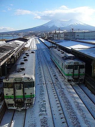
Noboribetsu is a city in Iburi Subprefecture, Hokkaido, Japan. Part of Shikotsu-Toya National Park, it is southwest of Sapporo, west of Tomakomai and northeast of Hakodate.

Date is a city in Iburi Subprefecture, Hokkaido, Japan. Date was established around 1869, and became a city on April 1, 1972.
Mori is a town located in Oshima Subprefecture, Hokkaido, Japan.

Oshamambe is a town located in Oshima Subprefecture, Hokkaido, Japan.

Rusutsu is a village located in Shiribeshi Subprefecture, Hokkaido, Japan.

Kutchan is a town located in Shiribeshi Subprefecture, Hokkaido, Japan. Kutchan lies slightly north of the volcano Mount Yōtei, and is approximately 50 kilometers west of Sapporo. The subprefecture government offices are located in this town, making it the capital of the subprefecture.

Onekotan is an uninhabited volcanic island located near the northern end of the Kuril Islands chain in the Sea of Okhotsk in the northwest Pacific Ocean. Its name is derived from the Ainu language for "large village”. It is the second largest island, after Paramushir, in the northern subgroup of the Kurils. It is administratively included in the Severo-Kurilsky District of Sakhalin oblast, Russia.

Ekarma is an uninhabited volcanic island near the center of the Kuril Islands chain in the Sea of Okhotsk in the northwest Pacific Ocean, separated from Shiashkotan Island by the Ekarma Strait. Its name is derived from the Ainu language, from “safe anchorage”.
Ketoy is an uninhabited volcanic island located in the centre of the Kuril Islands chain in the Sea of Okhotsk in the northwest Pacific Ocean. Its name is derived from the Ainu language for "skeleton" or "bad".

Kharimkotan ; Japanese 春牟古丹島; Harimukotan-tō, alternatively Harumukotan-tō or 加林古丹島; Karinkotan-tō) is an uninhabited volcanic island located 15 km (9 mi) from Onekotan near the northern end of the Kuril Islands chain in the Sea of Okhotsk in the northwest Pacific Ocean. Its name is derived from the Ainu language, from “village of many Cardiocrinum”.

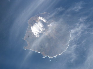
Simushir, meaning Large Island in Ainu, is an uninhabited volcanic island near the center of the Kuril Islands chain in the Sea of Okhotsk in the northwest Pacific Ocean. It was formerly known as Marikan.

Raikoke, also spelled Raykoke, is, as of 2019, a Russian uninhabited volcanic island near the centre of the Kuril Islands chain in the Sea of Okhotsk in the northwest Pacific Ocean, 16 kilometres (9.9 mi) distant from the island of Matua. Its name is derived from the Ainu language, from the Hokkaido Ainu word "hellmouth".

Rasshua is an uninhabited volcanic island near the center of the Kuril Islands chain in the Sea of Okhotsk in the northwest Pacific Ocean, 16 kilometres (9.9 mi) from Ushishir and 30 kilometres (19 mi) southwest of Matua. Its name is derived from the Ainu language for “fur coat”, "Rushu o a" (ルシュ・オ・ア), or "abundant furs", "Rushi o a" (ルシ・オ・ア).
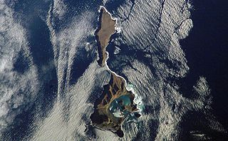
Ushishir is a collective name for two uninhabited volcanic islands and several reefs, all being parts of an eponymous partially submerged volcano, located in the centre of the Kuril Islands chain in the Sea of Okhotsk in the northwest Pacific Ocean. Its name is derived from the Ainu language for "hot spring".

Tōyako is a town in Iburi Subprefecture, Hokkaido, Japan. It was formed on March 23, 2006, through the merger of the town of Abuta and the village of Tōya. As of 1 October 2020, the town has an estimated population of 8,442, and a population density of 47 persons per km2. The total area is 180.54 km2.

Abira is a town located in Iburi Subprefecture, Hokkaido, Japan. As of 30 September 2016, the town has an estimated population of 8,323.
Iburi Province, also called Ifuri, was a short-lived province located in Hokkaidō. It corresponds to modern-day Iburi Subprefecture, Yamakoshi District of Oshima, Abuta District in Shiribeshi Subprefecture, the cities of Chitose and Eniwa in Ishikari Subprefecture and Shimukappu Village in Kamikawa Subprefecture.
Hoyau or hoyau kamui, in Ainu mythology, is a type of malodorous and venomous dragon or dragon god, believed to thrive in summer or near fire, but lose strength in the cold, whose trait earns it the alternative name of sak-somo-ayep.
The Sumunkur Ainu is the name of the Ainu subgroup living along the southern coast of Hokkaido, traditionally from Iburi to Hidaka. The subgroup is known to have fought with the Menasunkur Ainu to the east in the 17th century. In Japanese texts, they were also called the Haekuru Ainu and the Sarunkuru Ainu.


