Uedem

Last updated
Uedem
St. Laurentiuskirche Uedem Germany PM17-1.jpg
Flagge Uedem.svg
DEU Uedem COA.svg
Location of Uedem within Kleve district
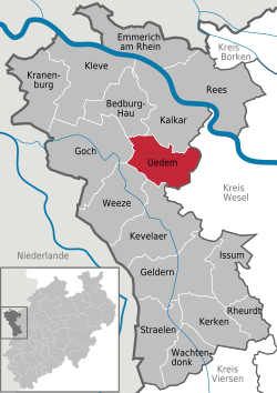
Uedem in KLE.svgKranenburgRees
Germany adm location map.svg
Red pog.svg
Uedem
North Rhine-Westphalia location map 01.svg
Red pog.svg
Uedem
Coordinates: 51°40′3″N6°16′30″E / 51.66750°N 6.27500°E / 51.66750; 6.27500
Country Germany
State North Rhine-Westphalia
Admin. region Düsseldorf
District Kleve
Government
   Mayor (202025) Rainer Weber [1] (CDU)
Area
  Total60.94 km2 (23.53 sq mi)
Elevation
21 m (69 ft)
Population
 (2021-12-31) [2]
  Total8,362
  Density140/km2 (360/sq mi)
Time zone UTC+01:00 (CET)
  Summer (DST) UTC+02:00 (CEST)
Postal codes
47589
Dialling codes 0 28 25
Vehicle registration KLE
Website www.uedem.de

Uedem is a municipality in the district of Cleves, in North Rhine-Westphalia, Germany. It is located near the border with the Netherlands.

Contents

Division of the town

Uedem consists of 4 districts


History

The history of Uedem goes back to the 5th century when Frankish nobleman Udo started a settlement in the area. In 866, the first official mention of "Odeheimero Marca" appeared.[ citation needed ] with Uedem gaining town privileges in 1359.

In November 1614, the Treaty of Xanten was signed in Cleves, dividing some of the territory around Uedem.

Uedem Reformed Church Uedem, die evangelische Kirche DmA-04-03-86 foto6 2016-05-05 16.00.jpg
Uedem Reformed Church


From 1794 onwards, the First French Republic occupied the city of Uedem, with them revoking town privileges to the city in 1798. The occupation ended in 1814 with the First Peace of Paris.

After the Nazi takeover in 1933, Uedem fell under the administrative control of Gau Essen. Bombing during World War 2 destroyed parts of Uedem, but the city has since recovered. After the war, Uedem became a center for Bundeswehr operations, and since 1993 has hosted the NATO Combined Air Operations Centre Uedem. [3]

Notable people

Related Research Articles

<span class="mw-page-title-main">Soest, Germany</span> Town in North Rhine-Westphalia, Germany

Soest, as if it were 'Sohst'; Westphalian: Saust) is a city in North Rhine-Westphalia, Germany. It is the capital of the Soest district.

<span class="mw-page-title-main">Kleve</span> Place in North Rhine-Westphalia, Germany

Kleve ; traditional English: ClevesKLEEVZ; Dutch: Kleef; French: Clèves; Spanish: Cléveris; Latin: Clivia; Low Rhenish: Kleff) is a town in the Lower Rhine region of northwestern Germany near the Dutch border and the River Rhine. From the 11th century onwards, Cleves was capital of a county and later a duchy. Today, Cleves is the capital of the district of Kleve in the German state of North Rhine-Westphalia. The city is home to one of the campuses of the Rhine-Waal University of Applied Sciences.

<span class="mw-page-title-main">Horstmar</span> Town in North Rhine-Westphalia, Germany

Horstmar is a German town, located in North Rhine-Westphalia in the Steinfurt district, approx. 25 km (16 mi) north-west of Münster.

<span class="mw-page-title-main">Wesel</span> Town in North Rhine-Westphalia, Germany

Wesel ) is a city in North Rhine-Westphalia, Germany. It is the capital of the Wesel district.

<span class="mw-page-title-main">Meinerzhagen</span> Town in North Rhine-Westphalia, Germany

Meinerzhagen ) is a town in the Märkischer Kreis, North Rhine-Westphalia, Germany.

<span class="mw-page-title-main">Mettmann</span> Town in North Rhine-Westphalia, Germany

Mettmann ) is a town in the northern part of the Bergisches Land, in North Rhine-Westphalia, Germany. It is the administrative centre of the district of Mettmann, Germany's most densely populated rural district. The town lies east of Düsseldorf and west of Wuppertal.

<span class="mw-page-title-main">Euskirchen</span> Town in North Rhine-Westphalia, Germany

Euskirchen ; Ripuarian: Öskerche) is a town in North Rhine-Westphalia, Germany, capital of the district Euskirchen. While Euskirchen resembles a modern shopping town, it also has a history dating back over 700 years, having been granted town status in 1302. As of December 2007, it had a population of 55,446. Its local football club is called TSC Euskirchen.

<span class="mw-page-title-main">Heinsberg</span> Town in North Rhine-Westphalia, Germany

Heinsberg ; Limburgish: Hinsberg[ˈhɪnzˌbæʀ˦(ə)ç]) is a town in North Rhine-Westphalia, Germany. It is the seat of the district Heinsberg. It is situated near the border with the Netherlands, on the river Wurm, approx. 20 km north-east of Sittard and 30 km south-west of Mönchengladbach.

<span class="mw-page-title-main">Dülmen</span> Place in North Rhine-Westphalia, Germany

Dülmen ) is a town in the district of Coesfeld, North Rhine-Westphalia, Germany.

<span class="mw-page-title-main">Werne</span> Town in North Rhine-Westphalia, Germany

Werne an der Lippe ; Westphalian: Wäen) is a town in the Federal state of North Rhine-Westphalia in the Unna district in Germany. It is located on the southern edge of the Münsterland region near the Ruhrgebiet. The population of Werne is about 32,000.

<span class="mw-page-title-main">Goch</span> Town in North Rhine-Westphalia, Germany

Goch ; archaic spelling: Gog, Dutch: Gogh) is a town in the district of Kleve, in North Rhine-Westphalia, Germany. It is situated close to the border with the Siebengewald in Netherlands, approx. 12 km (7 mi) south of Kleve, and 27 km (17 mi) southeast of Nijmegen.

<span class="mw-page-title-main">Geilenkirchen</span> Town in North Rhine-Westphalia, Germany

Geilenkirchen, Ripuarian: Jellekerke[ˈjæləˌkæʀ˦(ə)kə]) is a town in the district Heinsberg, in North Rhine-Westphalia, Germany. It is situated near the border with the Netherlands, on the river Wurm, approx. 15 km (9.3 mi) north-east of Heerlen and 20 km (12.4 mi) north of Aachen.

<span class="mw-page-title-main">Dorsten</span> Town in North Rhine-Westphalia, Germany

Dorsten is a town in the district of Recklinghausen in North Rhine-Westphalia, Germany and has a population of about 75,000.

<span class="mw-page-title-main">Kalkar</span> Town in North Rhine-Westphalia, Germany

Kalkar is a municipality in the district of Kleve, in North Rhine-Westphalia, Germany. It is located near the Rhine, approx. 10 km south-east of Cleves. The catholic church St. Nicolai has preserved one of the most significant sacral inventories from the late Middle Ages in Germany.

<span class="mw-page-title-main">Rees, Germany</span> Town in North Rhine-Westphalia, Germany

Rees is a town in the district of Kleve in the state of North Rhine-Westphalia, Germany. It is located on the right bank of the Rhine, approximately 20 km east of Kleve. The population in 2005 was 22,559. Founded in 1228, Rees is the oldest town in the lower Rhine area.

<span class="mw-page-title-main">Straelen</span> Town in North Rhine-Westphalia, Germany

Straelen is a municipality in the district of Cleves, in North Rhine-Westphalia, Germany. It is located near the border with the Netherlands, approx. 10 km north-east of Venlo.

<span class="mw-page-title-main">Kranenburg, North Rhine-Westphalia</span> Municipality in North Rhine-Westphalia, Germany

Kranenburg is a town and municipality in the district of Cleves in the state of North Rhine-Westphalia, Germany. It is located near the border with the Netherlands, 12 kilometres (7 mi) south-east of Nijmegen and 11 kilometres (7 mi) west of Cleves.

<span class="mw-page-title-main">Rheurdt</span> Municipality in North Rhine-Westphalia, Germany

Rheurdt is a municipality in the district of Cleves, in North Rhine-Westphalia, Germany. It is located approximately 10 kilometres (6.2 mi) west of Moers.

<span class="mw-page-title-main">Borgholzhausen</span> Town in North Rhine-Westphalia, Germany

Borgholzhausen is a town in the district of Gütersloh in the state of North Rhine-Westphalia, Germany. It is located in the Teutoburg Forest, approx. 20 km north-west of Bielefeld.

<span class="mw-page-title-main">Sonsbeck</span> Municipality in North Rhine-Westphalia, Germany

Sonsbeck is a municipality in the district of Wesel, in North Rhine-Westphalia, Germany. It is situated approximately 20 km west of Wesel, and 25 km south-east of Cleves as well as 8 km from the historic city of Xanten.

References

  1. Wahlergebnisse in NRW Kommunalwahlen 2020, Land Nordrhein-Westfalen, accessed 21 June 2021.
  2. "Bevölkerung der Gemeinden Nordrhein-Westfalens am 31. Dezember 2021" (in German). Landesbetrieb Information und Technik NRW . Retrieved 20 June 2022.
  3. https://ac.nato.int/about/caoc/uedem

Commons-logo.svg Media related to Uedem at Wikimedia Commons