Emmerich am Rhein

Last updated
Emmerich
Emmerich am Rhein Osten.jpg
Emmerich am Rhein as seen from the east
Flagge Emmerich.svg
DEU Emmerich COA.svg
Location of Emmerich within Kleve district
Emmerich am Rhein in KLE.svgKranenburgRees
Germany adm location map.svg
Red pog.svg
Emmerich
North Rhine-Westphalia location map 01.svg
Red pog.svg
Emmerich
Coordinates: 51°50′6″N6°14′43″E / 51.83500°N 6.24528°E / 51.83500; 6.24528
Country Germany
State North Rhine-Westphalia
Admin. region Düsseldorf
District Kleve
Founded700
Subdivisions8
Government
   Mayor (202025) Peter Hinze [1] (SPD)
Area
  Total80.11 km2 (30.93 sq mi)
Elevation
15 m (49 ft)
Population
 (2021-12-31) [2]
  Total30,854
  Density390/km2 (1,000/sq mi)
Time zone UTC+01:00 (CET)
  Summer (DST) UTC+02:00 (CEST)
Postal codes
46446
Dialling codes 0 28 22
0 28 28 (Elten)
Vehicle registration KLE
Website www.emmerich.de

Emmerich am Rhein (Low Rhenish and Dutch : Emmerik) is a city and municipality in the northwest of the German federal state of North Rhine-Westphalia. The city has a harbour and a quay at the Rhine. In terms of local government organization, it is a medium-sized city belonging to the district of Kleve in the administrative region (Regierungsbezirk) of Düsseldorf.

Contents

Geography

Emmerich lies on the north bank of the Rhine, just within the German borders, and is the last German town on the Rhine before the river flows into the Netherlands, which is 4 km to the north and 5 km to the west.

Villages belonging to Emmerich am Rhein

The populated places which comprise the municipality of Emmerich am Rhein are Emmerich, Borghees, Dornick, Elten, Hüthum, Klein-Netterden, Leegmeer, Praest, Speelberg and Vrasselt.

Neighboring municipalities and cities

To the north, the municipality of Emmerich borders the Dutch municipalities Montferland, Oude IJsselstreek and 's-Heerenberg; all of which are in the Dutch province of Gelderland. To the east, it is bordered by the German city of Rees. To the south, it is bordered by the Rhine, and south of this river, by the German city of Kleve. To the west, it is bordered by the Dutch municipalities of Rijnwaarden and Zevenaar, both of which are also in the Dutch province of Gelderland.

History

Emmerich, formerly called Embrika and Emrik, was originally a Roman colony. [3] Around the year 700 Saint Willibrord founded the mission "Emmerich" in the Utrecht diocese. The oldest documented name is Villa Embrici, which survives from the year 828.

The Water Gate in Emmerich am Rhein by Jan van der Heyden, c. 1664 Jan van der Heyden (Attr.) - The Water Gate in Emmerich am Rhein.jpg
The Water Gate in Emmerich am Rhein by Jan van der Heyden, c. 1664

The collegiate church St. Martinikirche was constructed in 1040.

On 31 May 1233 Count Otto von Zutphen and Gelder arose to the royalty of the prosperous city with the authorization of the Roman Emperor Frederick II and the German King Henry (VII) Emmerich. In 1371 it fell to the Duchy of Cleves, and passed with it in 1609 to the Margraviate of Brandenburg. The town joined the Hanseatic League in 1407. In 1794 it was bombarded by the French under General Vandamme, and in 1806 it was assigned to the Duchy of Berg. It passed into the possession of Prussia in 1815. [3]

In 1856 the railway section Oberhausen-Arnhem, of the Cologne-Mindener Railway was opened.

Emmerich was 91% destroyed on 7 October 1944 [4] [5] [6] as a strategic bombing target of the Oil Campaign of World War II.[ citation needed ] In 1949, Elten was annexed by the Netherlands until 1963.

Since 1 February 2001 the city has officially been called Emmerich am Rhein, until then it was simply Emmerich. [7]

On 28 November 2004 the four Catholic congregations of the city (St. Martini, St. Aldegundis, Heilig-Geist and Liebfrauen) combined to form the new city parish St. Christophorus.

Municipality and county reform

As a part of the 1st municipal restructuring program, the municipalities of Borghees, Dornick, Hüthum, Klein-Netterden, Praest and Vrasselt were integrated into the city of Emmerich on 1 July 1969. In the course of the 2nd restructuring program, the municipality of Elten was integrated as well, on 1 January 1975.

Places of interest

Rhine Promenade. Emmerich's Rhine promenade is a popular spot for locals and visitors alike, offering peaceful views across the Rhine river and Emmerich's iconic Rhine Bridge. Having undergone a complete refurbishment between 2003 - 2007, the 1 km long promenade also boasts a variety of restaurants, coffee shops and the Rheinpark with its playground.

Geistmarkt and Farmer's Market. Located in close proximity to the Rhine Promenade is the Geistmarkt, which hosts Emmerich's Farmer's Market every Wednesday and Saturday. Shoppers have a wide choice of fresh produce ranging from vegetables, fruits, fresh fish, meat, antipasti as well as flowers.

Steinstraße. Running adjacent to the Rhine Promenade, the Steinstraße is Emmerich's main shopping mile, boasting a number of shops. Recent refurbishments have also opened up opportunities for new business ventures that are looking for a new HQ.

Kaßstraße. Shoppers who are looking for additional shops and eateries can explore the Kaßstraße, which is a mere 5 minute walk from the Steinstraße.

Rhine Museum. In the Rhine Museum, 130 ship models are exhibited, as well as a radar unit, examples of fish taxidermy, maps of the Rhine, a historic Christophorus figurine and a library of the city's history. In addition there is a Biber submarine, a one-man U-boat from World War II and exhibitions regarding shipping on the Rhine, the history of the city and fisheries.

PAN-Art Forum/Poster Museum. The famous poster collection is displayed in the former Lohmann chocolate factory in rotating exhibits.

Aero Club Emmerich e.V.. Aviation fans and adrenalin junkies are encouraged to visit Emmerich's aero glider club 'Aero Club Emmerich e.V.'.

Holy Ghost Church This Catholic church was built in 1966 and is especially striking due to its version of the cross made of scrap metal and the Stations of the Cross made of linen. The architectural development during the time of the Second Vatican Council shaped the design of the church.

The Christuskirche. Emmerich am Rhein Christuskirche.jpg
The Christuskirche.

Rhine Bridge . This bridge, which connects Emmerich on the north of the Rhine with Kleve on the south, was opened in 1965, and with a length of 803 meters and a span of 500 meters it is the longest suspension bridge in Germany. Approximately 500 ships pass underneath it every day.

Castle Borghees. The manor house Borghees used as a cultural center was expanded in its present form in the mid-18th century. Borghees Castle became historically well known due to a love affair of the 17-year-old Katharina Rickers, the later imperial countess of Wartenberg, with the Prussian king Friedrich I.

Transport

Railways

Emmerich station is located about 1 km southeast of the city center on the double-track electrified "Holland Route," which plays an important role in passenger travel and commercial transport and is therefore treated in the EU as a part of the Trans-European Network in the category "priority projects which should be begun before 2010." In addition to the ICE International from Amsterdam to Frankfurt am Main, the night train CityNightLine to southern Germany, Austria and to Switzerland travels through here with a stop in Emmerich.

With regards to regional rail transport, the following trains pass through Emmerich, in general every hour:

PAN-Forum (poster museum). Emmerich am Rhein PAN-Forum.jpg
PAN-Forum (poster museum).

There is another station located on the same line near Emmerich, the stop Praest, which is only served by the Regional Train Der Weseler (RB 35).

Roads

Emmerich lies on the A3 motorway (known in German as the Bundesautobahn 3), which has the European designation E35. It also lies on the B8 (the Bundesstrasse 8) and the B220.

Inland waterways

Emmerich am Rhein, bridge across the Rhine Emmerich, brug over de Rijn foto3 2011-02-09 13.36.JPG
Emmerich am Rhein, bridge across the Rhine

Notable people

Twin towns – sister cities

Emmerich am Rhein is twinned with: [8]

Related Research Articles

<span class="mw-page-title-main">North Rhine-Westphalia</span> State in Germany

North Rhine-Westphalia or North-Rhine/Westphalia, commonly shortened to NRW, is a state (Land) in Western Germany. With more than 18 million inhabitants, it is the most populous state in Germany. Apart from the city-states, it is also the most densely populated state in Germany. Covering an area of 34,084 square kilometres (13,160 sq mi), it is the fourth-largest German state by size.

<span class="mw-page-title-main">Kleve</span> Place in North Rhine-Westphalia, Germany

Kleve is a town in the Lower Rhine region of northwestern Germany near the Dutch border and the River Rhine. From the 11th century onwards, Cleves was capital of a county and later a duchy. Today, Cleves is the capital of the district of Kleve in the German state of North Rhine-Westphalia. The city is home to one of the campuses of the Rhine-Waal University of Applied Sciences.

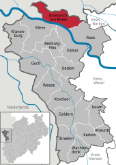
Kleve or Kreis Kleve is a Kreis in the Lower Rhine region of northwestern North Rhine-Westphalia, Germany. Neighbouring districts are Borken, Wesel, and Viersen in Germany, and the Dutch provinces of Limburg and Gelderland.

Viersen is a Kreis (district) in the west of North Rhine-Westphalia, Germany. Neighboring districts are Cleves, Wesel, district-free Krefeld, Neuss, district-free Mönchengladbach, Heinsberg and the Dutch province of Limburg.

<span class="mw-page-title-main">Rhine-Ruhr metropolitan region</span> Urban area in Germany

The Rhine-Ruhr metropolitan region is the largest metropolitan region in Germany, with over ten million inhabitants. A polycentric conurbation with several major urban concentrations, the region covers an area of 7,110 square kilometres (2,750 sq mi), entirely within the federal state of North Rhine-Westphalia. The Rhine-Ruhr metropolitan region spreads from the Ruhr area (Dortmund-Bochum-Essen-Duisburg) in the north to the urban areas of the cities of Mönchengladbach, Düsseldorf, Wuppertal, Leverkusen, Cologne, and Bonn in the south. The location of the Rhine-Ruhr at the heart of the European Blue Banana makes it well connected to other major European cities and metropolitan areas such as the Randstad, the Flemish Diamond and the Frankfurt Rhine Main Region.

<span class="mw-page-title-main">Bocholt, Germany</span> Town in North Rhine-Westphalia, Germany

Bocholt is a city in the north-west of North Rhine-Westphalia, Germany, part of the district Borken. It is situated 4 km south of the border with the Netherlands. Suderwick is part of Bocholt and is situated at the border annex to Dinxperlo.

<span class="mw-page-title-main">Goch</span> Town in North Rhine-Westphalia, Germany

Goch is a town in the district of Kleve, in North Rhine-Westphalia, Germany. It is situated close to the border with the Siebengewald in Netherlands, approx. 12 km (7 mi) south of Kleve, and 27 km (17 mi) southeast of Nijmegen.

<span class="mw-page-title-main">Wesseling</span> Town in North Rhine-Westphalia, Germany

Wesseling is an industrial German city on the Rhine bordering Cologne city on the south. With three chemical plants and a petroleum refinery within its city limits, it has an important place in the international petrochemical industry.

<span class="mw-page-title-main">Rees, Germany</span> Town in North Rhine-Westphalia, Germany

Rees is a town in the district of Kleve in the state of North Rhine-Westphalia, Germany. It is located on the right bank of the Rhine, approximately 20 km east of Kleve. The population in 2005 was 22,559. Founded in 1228, Rees is the oldest town in the lower Rhine area.

<span class="mw-page-title-main">Kranenburg, North Rhine-Westphalia</span> Municipality in North Rhine-Westphalia, Germany

Kranenburg is a town and municipality in the district of Cleves in the state of North Rhine-Westphalia, Germany. It is located near the border with the Netherlands, 12 kilometres (7 mi) south-east of Nijmegen and 11 kilometres (7 mi) west of Cleves.

<span class="mw-page-title-main">Alfter</span> Municipality in North Rhine-Westphalia, Germany

Alfter is a municipality in the Rhein-Sieg district, in North Rhine-Westphalia, Germany. It is situated approximately 6 km west of Bonn.

<span class="mw-page-title-main">Emmerich Rhine Bridge</span> Bridge in Emmerich am Rhein, Germany

The Emmerich Rhine Bridge is a suspension bridge located in Emmerich am Rhein, Germany. Completed in 1965, it has a main span of 500 metres (1,600 ft), crossing the Rhine, carrying the Bundesstraße B 220, the federal highway between Emmerich am Rhein and Kleve. It is the longest suspension bridge in Germany.

<span class="mw-page-title-main">Dutch annexation of German territory after the Second World War</span> 1945–63 occupation of West German territory by the Netherlands while WWII reparations were paid

At the end of World War II, plans were made in the Netherlands to annex German territory as compensation for the damages caused by the war. In October 1945, the Dutch state asked Germany for 25 billion guilders in reparations. In February 1945 it had already been established at the Yalta Conference that reparations would not be given in monetary form. The plan which was worked out in most detail was the one made by Frits Bakker Schut, and hence became known as the Bakker Schut Plan or Groot Nederland Plan.

Elten is a German village located in North Rhine-Westphalia. It has a population of around 4,500. Since 1975, it has been part of the town of Emmerich am Rhein. Between 1949 and 1963, Elten was part of the Netherlands. There is a substantial minority of Dutch citizens.

<span class="mw-page-title-main">Lower Left Rhine Railway</span>

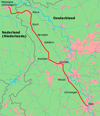
The Left Lower Rhine line is a main line on the left (western) bank of the Rhine in the lower Rhine region of the German state of North Rhine-Westphalia, running from Cologne to Cleves (Kleve) and formerly via Kranenburg to Nijmegen in the Netherlands. The Cologne–Krefeld section of the line was opened by the Cöln-Crefeld Railway Company in 1855 and is one of the oldest lines in Germany.

The Spyck–Welle train ferry was a train ferry on the Rhine between Spyck on the left (southern) bank and Welle on the right bank in the lower Rhine region of the German state of North Rhine-Westphalia. It was established in 1865 by the Rhenish Railway Company on the Lower Left Rhine line from Cologne to Neuss, Krefeld, Cleves, Elten, Zevenaar and the Dutch North Sea ports.

<span class="mw-page-title-main">Emmerich station</span> Railway station in Germany

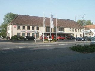
Emmerich is a railway station in Emmerich am Rhein, North Rhine-Westphalia, Germany.

<span class="mw-page-title-main">Rhein-Express</span>

The Rhein-Express is a Regional-Express service, which generally follows the Rhine river. It runs daily every hour from 5 am to 9 pm from Wesel via Oberhausen, Duisburg, Düsseldorf, Cologne, Bonn, Remagen and Andernach to Koblenz, in the German states of North Rhine-Westphalia and Rhineland-Palatinate. It is the fourth-most used regional express line in the VRR network with approximately 48,000 passengers a day.

<span class="mw-page-title-main">Wild (river)</span> River in The Netherlands, Germany

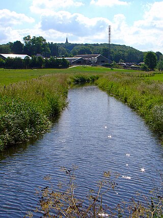
Die Wild is a small stream on the border between Germany and The Netherlands. It flows south of the Dutch town of 's-Heerenberg and the German village of Elten towards the north of the Dutch village of Spijk. North of Lobith it flows into the Oude Rijn, an old branch of the Rhine.

<span class="mw-page-title-main">Rhein-IJssel-Express</span> German and Dutch rail service

The Rhein-IJssel-Express is a Regional-Express service in German state of North Rhine-Westphalia and the Dutch province of Gelderland. It runs from Düsseldorf to Arnhem, with a section splitting at Wesel to serve Bocholt. VIAS operates the service on behalf of Verkehrsverbund Rhein-Ruhr (VRR).

References

  1. Wahlergebnisse in NRW Kommunalwahlen 2020, Land Nordrhein-Westfalen, accessed 21 June 2021.
  2. "Bevölkerung der Gemeinden Nordrhein-Westfalens am 31. Dezember 2021" (in German). Landesbetrieb Information und Technik NRW . Retrieved 20 June 2022.
  3. 1 2 Wikisource-logo.svg One or more of the preceding sentences incorporates text from a publication now in the public domain :  Chisholm, Hugh, ed. (1911). "Emmerich". Encyclopædia Britannica . Vol. 9 (11th ed.). Cambridge University Press. p. 342.
  4. Royal Air Force Bomber Command. Campaign Diary October 1944 Archived June 11, 2007, at the Wayback Machine
  5. Friedrich, Jörg: The fire. The bombing of Germany, 1940-1945. Columbia University Press, New York 2008, ISBN   978-0-231-13381-4, p. 115
  6. Schnatz, Helmut: Die Zerstörung der deutschen Städte und die Opfer. in: Hessische Landeszentrale für politische Bildung: Der Bombenkrieg und seine Opfer, Polis Nr. 39, Frankfurt am Main 2004 Archived 2011-07-19 at the Wayback Machine p. 44, PDF
  7. Stadtinformation - Daten und Fakten Stadt Emmerich
  8. "Partnerstädte". emmerich.de (in German). Emmerich am Rhein. Retrieved 2021-02-02.
  9. "Kirkland Councilman meets with sister city mayor in Germany on his own dime". Kirkland Reporter. 10 September 2013. Retrieved 23 November 2022.
  10. Washington State Lieutenant Governor's Office. "Washington's Sister Cities Relationships" . Retrieved 23 November 2022.