Ugocsa County

Last updated

Ugocsa County
County of
Coa Hungary County Ugocsa (history).svg
Coat of arms
Ugocsa.png
Ugocsa County in the Kingdom of Hungary (highlighted in darker grey)
Capital Nagyszőllős
Area
  Coordinates 48°8′N23°2′E / 48.133°N 23.033°E / 48.133; 23.033
 
 1910
1,213 km2 (468 sq mi)
Population 
 1910
91,755
History 
 Established
14th century
 Merged into Bereg-Ugocsa County
1785
 County recreated
1790
 Merged into Bereg County
1850
 County recreated
1860
 Treaty of Trianon
4 June 1920
 Merged into Szatmár-Ugocsa-Bereg County
1923
 Merged into Bereg-Ugocsa County (First Vienna Award)
2 November 1938
 County recreated (Second Vienna Award)
30 August 1940
 Merged into Szatmár-Bereg County
1945
Today part of
Vynohradiv is the current name of the capital.

Ugocsa was an administrative county (comitatus) of the Kingdom of Hungary. Its territory is now in north-western Romania (14) and western Ukraine (34). The capital of the county was Nagyszőllős (now Vynohradiv, Ukraine).

Contents

Geography

Map of Ugocsa, 1891. Ugocsa county map.jpg
Map of Ugocsa, 1891.

Ugocsa county shared borders with the Hungarian counties Máramaros, Szatmár and Bereg. It was situated on both sides of the river Tisza. Its area was 1208 km2 around 1910.

History

In 1920, by the Treaty of Trianon most of the county (including Nagyszőllős) became part of newly formed Czechoslovakia, while a very little part remained in Hungary were joined to Szatmár County, which was merged to Szatmár-Ugocsa-Bereg County in 1923. The southern part – including Halmi (today Halmeu) – became part of Romania. In 1938, the western part of the former Czechoslovak part was returned to Hungary by the First Vienna Award, which became part of the newly formed Bereg-Ugocsa County – as Szatmár County was recreated – but shortly in 1939 the rest became part of Hungary again as the remainder of Carpathian Ruthenia was annexed after Czechoslovakia ceased to exist. These part were assigned to the administrative branch offices of Máramaros. In 1940, by the Second Vienna Award the southern part as well returned to Hungary thus the county was recreated with a modified territory, with the parts also included earlier to the administrative branch offices of Máramaros. The capital again became Nagyszőllős.

After World War II, the formerly Czechoslovak part of Ugocsa county became part of the Soviet Union, Ukrainian SSR, Zakarpattia Oblast. Since 1991, when the Soviet Union split up, the Zakarpattia Oblast has been part of Ukraine. The southern part of the county became part of Romania again and is now part of the Romanian county Satu Mare.

Demographics

Ethnic map of the county with data of the 1910 census (see the key in the description). Ugocsa ethnic map.png
Ethnic map of the county with data of the 1910 census (see the key in the description).
Population by native language [lower-alpha 1]
CensusTotal Hungarian Ruthenian Romanian German Other or unknown
1880 [1] 65,37722,664 (35.67%)29,976 (47.17%)8,183 (12.88%)2,409 (3.79%)314 (0.49%)
1890 [2] 75,46128,852 (38.23%)32,076 (42.51%)8,830 (11.70%)5,447 (7.22%)256 (0.34%)
1900 [3] 83,31635,702 (42.85%)32,721 (39.27%)9,270 (11.13%)5,505 (6.61%)118 (0.14%)
1910 [4] 91,75542,677 (46.51%)34,415 (37.51%)9,750 (10.63%)4,632 (5.05%)281 (0.31%)
Population by religion [lower-alpha 2]
CensusTotal Greek Catholic Calvinist Jewish Roman Catholic Other or unknown
188065,37741,808 (63.95%)10,246 (15.67%)7,835 (11.98%)5,394 (8.25%)94 (0.14%)
189075,46147,651 (63.15%)11,722 (15.53%)9,414 (12.48%)6,201 (8.22%)473 (0.63%)
190083,31652,417 (62.91%)12,928 (15.52%)10,566 (12.68%)7,264 (8.72%)141 (0.17%)
191091,75557,550 (62.72%)14,002 (15.26%)11,850 (12.91%)8,173 (8.91%)180 (0.20%)

Subdivisions

Ugocsa county administrative map.jpg

In the early 20th century, the subdivisions of Ugocsa county were:

Districts (járás)
DistrictCapital
  TiszáninnenNagyszőllős (now Vynohradiv)
  TiszántúlHalmi (now Halmeu)

Vynohradiv is now in Ukraine; Halmeu is now in Romania.

Related Research Articles

<span class="mw-page-title-main">Hont County</span> County of the Kingdom of Hungary

Hont County was an administrative county (comitatus) of the Kingdom of Hungary. Most of its territory is now part of Slovakia, while a smaller southern portion is part of Hungary.

<span class="mw-page-title-main">Bars County</span> County of the Kingdom of Hungary

Bars was an administrative county (comitatus) of the Kingdom of Hungary. Its territory is now in central and southern Slovakia. Today in Slovakia, Tekov is the informal designation of the corresponding territory.

<span class="mw-page-title-main">Nyitra County</span> County of the Kingdom of Hungary

Nyitra County was an administrative county (comitatus) of the Kingdom of Hungary. Its territory lay in what is now western Slovakia.

<span class="mw-page-title-main">Bereg County</span> County of the Kingdom of Hungary

Bereg was an administrative county (comitatus) of the Kingdom of Hungary. Its territory is now mostly in western Ukraine and a smaller part in northeastern Hungary. The capital of the county was Beregszász.

<span class="mw-page-title-main">Ung County</span> County of the Kingdom of Hungary

Ung County was an administrative county (comitatus) of the Kingdom of Hungary. Its territory is now mostly in western Ukraine, a smaller part in eastern Slovakia, and a very small area in Hungary.

<span class="mw-page-title-main">Máramaros County</span> County of the Kingdom of Hungary

Máramaros County was an administrative county (comitatus) of the Kingdom of Hungary. Its territory is now in north-western Romania and western Ukraine. The capital of the county was Máramarossziget.

<span class="mw-page-title-main">Szabolcs County</span> County of the Kingdom of Hungary

Szabolcs was an administrative county (comitatus) of the Kingdom of Hungary. Its territory is now part of Hungary, except for three villages which are in the Zakarpattia Oblast of Ukraine. The capital of the county was Nyíregyháza.

<span class="mw-page-title-main">Szatmár County</span> County of the Kingdom of Hungary

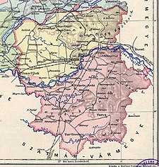
Szatmár County was an administrative county (comitatus) of the Kingdom of Hungary, situated south of the river Tisza. Most of its territory is now divided between Romania and Hungary, while a very small area is part of Ukraine. The capital of the county was Nagykároly.

<span class="mw-page-title-main">Szilágy County</span> County of the Kingdom of Hungary

Szilágy was an administrative county (comitatus) of the Kingdom of Hungary. Its territory is now in north-western Romania. The capital of the county was Zilah.

<span class="mw-page-title-main">Csanád County</span> Administrative county (comitatus) of the Kingdom of Hungary

Csanád was an administrative county (comitatus) of the Kingdom of Hungary. Its territory is now part of Hungary, except for a small area which is part of Romania. The capital of the county was Makó.

<span class="mw-page-title-main">Beszterce-Naszód County</span>

Beszterce-Naszód was an administrative county (comitatus) of the Kingdom of Hungary. Its territory is now in northern Romania. The capital of the county was Beszterce.

<span class="mw-page-title-main">Háromszék County</span>

Háromszék was an administrative county (comitatus) of the Kingdom of Hungary. Situated in south-eastern Transylvania, its territory is now in central Romania. The capital of the county was Sepsiszentgyörgy.

<span class="mw-page-title-main">Kis-Küküllő County</span> Administrative county (comitatus) of the Kingdom of Hungary

Kis-Küküllő was an administrative county (comitatus) of the Kingdom of Hungary. Its territory is now in central Romania. Kis-Küküllő is the Hungarian name for the river Târnava Mică. The capital of the county was Dicsőszentmárton.

<span class="mw-page-title-main">Kolozs County</span>

Kolozs County was an administrative county (comitatus) of the Kingdom of Hungary, of the Eastern Hungarian Kingdom and of the Principality of Transylvania. Its territory is now in north-western Romania. The capital of the county was Kolozsvár.

<span class="mw-page-title-main">Szeben County</span>

Szeben was an administrative county (comitatus) of the Kingdom of Hungary. Its territory is now in central Romania. The capital of the county was Nagyszeben.

<span class="mw-page-title-main">Szolnok-Doboka County</span>

Szolnok-Doboka was an administrative county (comitatus) of the Kingdom of Hungary. Its territory is now in northern Romania. The capital of the county was Dés.

<span class="mw-page-title-main">Árva County</span> County of the Kingdom of Hungary

Árva County was an administrative county (comitatus) of the Kingdom of Hungary since the 14th century until 1920. Its territory is now in northern Slovakia and southern Poland. Today, the Slovak name is only used as an informal designation of the corresponding territory.

<span class="mw-page-title-main">Gömör and Kishont County</span> County of the Kingdom of Hungary

Gömör-Kishont was an administrative county (comitatus) of the Kingdom of Hungary. Its capital was Rimaszombat. Most of its territory is now part of Slovakia, while a smaller part belongs to Hungary.

<span class="mw-page-title-main">Northern Maramureș</span>

Northern Maramureș is a geographic-historical region comprising roughly the eastern half of the Zakarpattia Oblast in southwestern Ukraine, near the border with Romania. Until 1920, it was part of the Maramureș subregion of Transylvania, at which time the former Máramaros County was divided into a northern part, and a southern part.

<span class="mw-page-title-main">Nógrád County (former)</span> County of the Kingdom of Hungary

Nógrád was an administrative county of the Kingdom of Hungary. Its territory is now divided between Hungary and Slovakia. The name Novohrad is still used in Slovakia as an informal designation of the corresponding territory. The name is derived from the former Nógrád castle in Hungary.

References

  1. "Az 1881. év elején végrehajtott népszámlálás főbb eredményei megyék és községek szerint rendezve, II. kötet (1882)". library.hungaricana.hu. Retrieved September 28, 2021.
  2. "A Magyar Korona országainak helységnévtára (1892)". library.hungaricana.hu. Retrieved September 29, 2021.
  3. "A MAGYAR KORONA ORSZÁGAINAK 1900". library.hungaricana.hu. Retrieved September 29, 2021.
  4. "KlimoTheca :: Könyvtár". Kt.lib.pte.hu. Retrieved September 29, 2021.

Notes

  1. Only linguistic communities comprising at least 1% of the population are displayed.
  2. Only religious communities comprising at least 1% of the population are displayed.