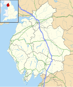
Cumbria is a ceremonial county in North West England. It borders the Scottish council areas of Dumfries and Galloway and Scottish Borders to the north, Northumberland and County Durham to the east, North Yorkshire to the south-east, Lancashire to the south, and the Irish Sea to the west. Its largest settlement is the city of Carlisle.

Ulverston is a market town and civil parish in Westmorland and Furness, Cumbria, England. In the 2001 census the parish had a population of 11,524, increasing at the 2011 census to 11,678. Historically in Lancashire, it lies a few miles south of the Lake District National Park and just north-west of Morecambe Bay, within the Furness Peninsula. Lancaster is 39 miles (63 km) to the east, Barrow-in-Furness 10 miles (16 km) to the south-west and Kendal 25 miles (40 km) to the north-east.

Westmorland was a county in North West England which occupied the southern Lake District and the southern Vale of Eden. It had an administrative function from the 12th century until 1974, when it became part of Cumbria. The people of Westmorland were known as Westmerians.

Kendal, once Kirkby in Kendal or Kirkby Kendal, is a market town and civil parish in the Westmorland and Furness district of Cumbria, England. It lies within the River Kent's dale, from which its name is derived, just outside the boundary of the Lake District National Park.
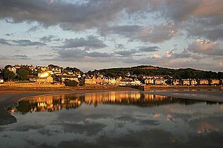
Grange-over-Sands is a town and civil parish on the north side of Morecambe Bay in Cumbria, England, a few miles south of the Lake District National Park. In the 2001 census the parish had a population of 4,042, increasing at the 2011 census to 4,114. Within the boundaries of the historic county of Lancashire, the town became administered as an urban district in 1894. Though the town remains part of the Duchy of Lancaster, since 2023 it has been administered as part of the Westmorland and Furness Council area.

South Lakeland was a local government district in Cumbria, England, from 1974 to 2023. Its council was based in Kendal. The district covered the southern part of the Lake District region, as well as northwestern parts of the Yorkshire Dales. At the 2011 Census, the population of the district was 103,658, an increase from 102,301 at the 2001 Census.
Arnside is a village and civil parish in Cumbria, historically part of Westmorland, near the border with Lancashire, England. The Lake District National Park is located a few miles north. Travelling by road, Arnside is 22 miles (35 km) to the south of Kendal, 25.3 miles (40.7 km) to the east of Ulverston, 35.2 miles (56.6 km) to the east of Barrow-in-Furness, 15.7 miles (25.3 km) to the west of Lancaster and 14.3 miles (23.0 km) to the east of Grange-over-Sands. In the 2001 census the parish had a population of 2,301, increasing at the 2011 census to 2,334.

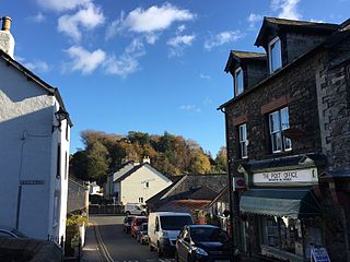
Kents Bank is a small village in Cumbria, England, so named for its proximity to the River Kent estuary. Part of the historic County Palatine of Lancashire, it is located 2 miles (3.2 km) south-west of Grange-over-Sands.

Westmorland and Lonsdale is a constituency in the south of Cumbria, represented in the House of Commons of the UK Parliament since 2005 by Tim Farron, the former leader of the Liberal Democrats (2015–2017).
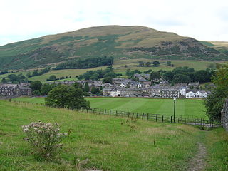
Sedbergh is a town and civil parish in the ceremonial county of Cumbria. It falls within the historic boundaries of the West Riding of Yorkshire. Since April 2023, it has been administered by Westmorland and Furness local authority. The 2001 census gave the parish a population of 2,705, increasing at the 2011 census to 2,765. It lies about 10 miles (16 km) east of Kendal, 28 miles (45 km) north of Lancaster and about 10 miles (16 km) north of Kirkby Lonsdale, within the Yorkshire Dales National Park. It stands at the foot of Howgill Fells, on the north bank of the River Rawthey, which joins the River Lune 2 miles (3 km) below the town.
Broughton in Furness is a market town in the civil parish of Broughton West in the Westmorland and Furness district of Cumbria, England. It had a population of 529 at the 2011 Census. It is located on the south western boundary of England's Lake District National Park, and in the Furness region, which is within the historic boundaries of Lancashire.

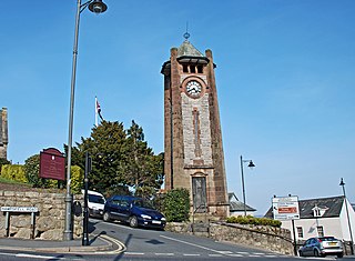
Hoad Monument is a 100-foot (30 m) tower at the top of the 436-foot (133 m) Hoad Hill, near Ulverston in Cumbria, England. It commemorates Sir John Barrow (1764-1848), who was born in Ulverston. It was built in 1850 at a cost of £1250, the cost being met mainly by public subscription.

Flookburgh is an ancient village on the Cartmel peninsula in Cumbria, England. Within the boundaries of the historic county of Lancashire and being close to Morecambe Bay, cockle and shrimp fishing plays a big part in village life. Flookburgh has a Haven Holidays site called Lakeland Leisure Park.
The high sheriff is the oldest secular office under the Crown. Formerly the high sheriff was the principal law enforcement officer in the county but over the centuries most of the responsibilities associated with the post have been transferred elsewhere or are now defunct, so that its functions are now largely ceremonial. The high sheriff changes every April.
George Webster was an English architect who practised in Kendal, which was at the time in Westmorland, and later in Cumbria. All of his works were executed near his practice, and were located in Cumbria, in north Lancashire, and in the adjacent parts of Yorkshire. Most of his work was carried out on domestic buildings, but he also designed churches, and public and commercial buildings.

Kentrigg is a northern suburb of Kendal, Cumbria, England. By road, Kentrigg is located 1.2 miles (1.9 km) north of the centre of Kendal and 1.4 miles (2.3 km) southeast of Burneside. It contains the Carus Green Golf Club, which separates it from Burneside just to the northwest. Across the River Kent to the east is the Shap Road Industrial Estate, north of the district of Mintsfeet and the Mintsfeet Industrial Estate which marks the southeastern side of Kentrigg.

The County Offices, also known as County Hall, is a municipal building in Stricklandgate, Kendal, Cumbria, England. The structure, which was the headquarters of Westmorland County Council from 1939 to 1974, is a Grade II listed building. The building serves as the meeting place of Westmorland and Furness Council.
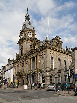
The Town Hall is a municipal building in Highgate, Kendal, Cumbria. It is a Grade II listed building. It serves as the headquarters of Kendal Town Council and also forms part of the complex of buildings which served as the headquarters of the former South Lakeland District Council.

Westmorland and Furness is a unitary authority area in Cumbria, England,. The economy is mainly focused on tourism around both the Lake District and Cumbria Coast, shipbuilding and the port in Barrow-in-Furness, and agriculture in the rural parts of the area.