
Amreli district is one of the 33 administrative districts of the state of Gujarat in western India. The district headquarters are located at Amreli. The district occupies an area of 6,760 km2 and has a population of 1,514,190 of which 22.45% were urban. Amreli is the land of Yogiji Maharaj(Dhari), Danbapu, Sage Muldas, Sage Bhojalrambapa, Sage Muktanand Swami, Magician K.Lal, Zaverchand Megahani's place (Bagasara), Dr. Jivaraj Mehata etc. Amreli covers Dhari Gir National forest sanctuary area. Now it is developing as a Hub of Education.
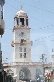
Amreli is a city and a municipality in Amreli district in Indian state of Gujarat.
Kariana is a small village in Amreli district in the state of Gujarat, India. It is on the road from Babra to Gadhda. You can also visit Ghela Somnath temple distance 15 from the Kariyana.
Bagasara is a municipality in Bagasara Taluka of Amreli district, Gujarat, India. The town is situated on the northern bank of the Satalli river. nearest airport div airport.
Rajula is a city and municipality in Amreli district in the Indian state of Gujarat. City was known as Rajgadh at the time of local ruler daha dhakhda.
Jalia is a small village in the Amreli District of Gujarat, India. It is located 22 kilometers (14 mi) from Amreli.

Dhari is a town in Amreli District in Indian state of Gujarat, India. It is an administrative headquarter of the Dhari tehsil(almost 87 villages and ness).Dhari is the most populous town in Amreli District as per census 2011 with 30352 population. Dhari is located on the bank of Shetrunji River, 42 km(26.2 mi) from district headquarter Amreli & 318 km(199.8 mi) from state capital Gandhinagar. Dhari is famous for kesar mango and Asiatic lion. Dhari is capital of East Gir Forest.
Gadhakda is a village in Savarkundla tehsil in the Amreli district of Indian state Gujarat. Gadhakda was formerly under the control of Junagadh State. Although it is now a part of the Amreli district, it was once a part of the Bhavnagar district.
Hathigadh is a village in Liliya tehsil, Amreli district, Gujarat, India. It has a High school and a Primary school. There is no river in the village, but a reservoir is under construction. There is a temple, Ramji Mandir. The village is surrounded by many big and old trees. The main occupation of the people of the village is farming.
Mota Zinzuda is a village near Savar Kundla, Amreli District, India. It is located 6 km from Savar Kundla. Mota Zinzuda is situated approximately 37km away from the district headquarters of Amreli.

The Bhal region is an area of Gujarat, India. It is spread across the political boundaries of the districts of Bhavnagar, Ahmedabad, and Anand. The Bhal region is situated on the deltas of the Sabarmati, Bhogawo, Bhadar, Lilka and other rivers that flow east and southeast off the Kathiawar peninsula into the Gulf of Cambay. The word Bhaal seems to have been derived from the Sanskrit word भाल which means forehead. Such a name is given to this region probably because it is mostly as flat as a forehead with almost entire region's soil without any stones, pebbles or gravel.

Tulsishyam is located on the border of Amareli, Junagadh district and Gir Somnath district, in the Gir National Park in Gujarat state of India. It reachable by road 45 km from Dhari in Amreli district and 35 km from Una in Gir Somnath district..
Mavjinjava (માવજીંજવા) is a small village near Bagasara in the Amreli district of the Saurashtra region in the state of Gujarat, India. There is a population of around 3,754 people in Mavjinjava. More than 3000 people live outside of Manjinjava in places like Surat, Ahmedabad & Mumbai.
Amreli is one of the 182 Legislative Assembly constituencies of Gujarat state in India.
Lathi is one of the 182 Legislative Assembly constituencies of Gujarat state in India. It is part of Amreli district.

Balel Pipariya is a City in the Amreli district, Gujarat, India.
Babra is a town and the taluka headquarter in the Amreli district, Gujarat, India. It is situated to the north of Amreli. The main road linking Rajkot and Bhavnagar and Amreli passes through Babra.
Akadia or Ankadia is a village and former Rajput petty princely state on Saurashtra peninsula.
Chavand is a village in Lathi taluka in Amreli district, Gujarat, India. It is situated to the north of Amreli. The main road linking Rajkot and Bhavnagar and Amreli passes through Chavand.
Amreli railway station is a railway station serving in Amreli district of Gujarat State of India. It is under Bhavnagar railway division of Western Railway Zone of Indian Railways. Passenger trains halt here.

