Upper Hessian Ridge

Last updated

The Upper Hessian Ridge (German : Oberhessische Schwelle) or Upper Hesse Ridge is a hill chain in the West Hesse Highlands in North and Middle Hesse, which lies on the Rhine-Weser watershed and links the montane Central Upland ranges of the Kellerwald and the Vogelsberg in a north-south direction. The swell is divided into the Gilserberg Heights (Gilserberger Höhen) in the north, the central Neustadt Saddle (Neustädter Sattel) and the Northern Vogelsberg Foreland (Nördliche Vogelsberg-Vorland) in the south.

Contents

View from the Amoneburg of the Gilserberg Heights with the Burgholz (379.1 m, left) and, on the Kellerwald behind, the Hohes Lohr (656.7 m, left, TV tower), Jeust (ca. 585 m, centre) and Wustegarten (675.3 m, right). Front left :the town of Kirchhain. Burgholz und Kellerwald von Amoeneburg.jpg
View from the Amöneburg of the Gilserberg Heights with the Burgholz (379.1 m, left) and, on the Kellerwald behind, the Hohes Lohr (656.7 m, left, TV tower), Jeust (ca. 585 m, centre) and Wüstegarten (675.3 m, right). Front left :the town of Kirchhain.

Location

In the north the Gilserberg Heights transition directly into the clearly much higher Kellerwald with its prominent hills, the Jeust and the Wüstegarten; to the northeast into the Löwenstein Bottom, which is part of the Ostwaldecker Randsenken.

Separated by the Wohra the ridge is adjoined in the northwest by the Burgwald at the Gilserberg Heights. In the southwest the Ohm and the flat Amöneburg Basin follows by the Neustadt Saddle and the Northern Vogelsberg Foreland.

The Vogelsberg Foreland goes in the extreme southwest – again with the Ohm as its boundary – into the Lumda Plateau. The Lumda Plateau is part of the so-called Anterior Vogelsberg (Vorderen Vogelsberg), which adjoins east of the Ohm valley in the south the Lower Vogelsberg (Untere Vogelsberg). Like the actual (High) Vogelsberg it belongs to the East Hesse Highlands (Osthessischen Bergland).

To the east of the three parts of the Upper Hessian Ridge is the West Hesse Depression (Westhessische Senke) in the shape of the Schwalm by the Eder tributary of the same name.

Natural region division

The Upper Hessian Ridge is part of the West Hesse Highlands (major unit group 34) and is subdivided as follows: [1]

Gilserberg Heights

The Gilserberg Heights are mostly forested; large parts of the northern area belong to the Treysa State Forest, its southwestern spur near Burgholz to the Rauschenberg State Forest and the Kirchhain Municipal Forest.

Whilst in the north, in the immediate neighbourhood zum noch gut 200 m höheren Kellerwald, noch Höhen von bis zu 470.6 m (Hundskopf) erreicht, flacht der Höhenzug nach Süden auf die maximale Gipfelhöhe von 379.1 m (Burgholz) ab.

Gilserberger Hohen.jpg
View from the Wolfskaute near Rauschenberg of the Gilserberg Heights, part of the Upper Hessian Ridge, which links the Vogelsberg (773.0 m, rear; far right) with the Kellerwald (up to 675.3 m, far left). Right: the Burgholz (379.1 m); centre right in the far distance is the Kirschenwald (up to 532.8 m) in the Knüll (up to 635.5 m); centre left is the Ernsthausen wind farm; far left and optically merged into one another are the Jeust (ca. 585 m) and the Wüstegarten (675.3 m); on the extreme left is the Hohes Lohr (656.7 m, TV transmitter)

Neustadt Saddle

View from the Amoneburg of the Neustadt Saddle and Knull (635.5 m). Immediately left of the saddle of the largely cleared Kruckeberg (345.4 m), which from a natural regional perspective counts as part of the saddle; right of the saddle is the plateau of the Northern Vogelsberg Foreland (388 m) Neustaedter Sattel-Knuell.jpg
View from the Amöneburg of the Neustadt Saddle and Knüll (635.5 m). Immediately left of the saddle of the largely cleared Krückeberg (345.4 m), which from a natural regional perspective counts as part of the saddle; right of the saddle is the plateau of the Northern Vogelsberg Foreland (388 m)

The (from a natural region perspective) very narrow, north-south oriented Neustadt Saddle is the lowest part of the Rhine-Weser watershed between the Kellerwald and the Vogelsberg. The Main-Weser Railway crosses it between Stadtallendorf and Neustadt at a height of about 285 m above  sea level (NN) , the B 454 federal highway also crosses it at just under 300 m above NN.

Whilst the Neustadt Saddle forms the actual low point on the ridge between the plateau of the Krückeberg (at the southern end of the Gilserberg Heights) to the north and the Wahlen Plateau (Wahlener Hochplateau, at the northern end of the Northern Vogelsberg Foreland) to the southeast, the Neustadt Saddle natural region also includes the Krückeberg, but not the Wahlen Plateau.

Mediterranean-Mjøsa Zone

The Neustadt Saddle is part of the Mediterranean-Mjøsa Zone, a sequence of valleys that runs from the Rhone valley along the Upper Rhine Graben, the Wetterau and the Gießen Basin, below the Anterior Vogelsberg to the Amöneburg Basin; from there via the Neustadt Saddle in the West Hesse Depression and on along the Leine Graben to the Oslo Graben. [2]

Northern Vogelsberg Foreland

The north of the Northern Vogelsberg Foreland is, in the immediate vicinity of the Neustadt Saddle, dominated by an entirely cleared plateau up to 388 metres high, around the villages of Wahlen, Arnshain und Gleimenhain in the borough of Kirtorf. Here there are various wind farms, the views extend in good weather as far as e.g. the Hoher Meißner, 70 kilometres away to the northeast, and is unbroken in almost all directions of the compass.

In the northwest lies the forest of Herrenwald which barely reaches 300 m above NN in height, near Stadtallendorf, the south is also largely wooded.

In the southwest flows the Gleen, which in the south is part of the boundary stream of the Lower Vogelsberg.

Hills (selection)

Places

The Gilserberg Heights lie within the counties of Schwalm-Eder-Kreis and Marburg-Biedenkopf, the Neustadt Saddle mainly within Marburg-Biedenkopf and the Northern Vogelsberg Foreland mainly in the Vogelsbergkreis (except for the far northwest where it is part of Marburg-Biedenkopf).

Important settlements are Gilserberg in the north, Jesberg on the northeastern edge, Schwalmstadt on the eastern side, Kirchhain on the western boundary, Stadtallendorf and Neustadt in the centre and Homberg (Ohm) and Kirtorf on the southern boundary.

Related Research Articles

Schwalm-Eder-Kreis is a Kreis (district) in the north of Hesse, Germany. Neighbouring districts are Kassel, Werra-Meißner, Hersfeld-Rotenburg, Vogelsberg, Marburg-Biedenkopf, and Waldeck-Frankenberg.

Lahn Right tributary of Rhine river in Germany

The Lahn is a 245.6-kilometre-long (152.6 mi), right tributary of the Rhine in Germany. Its course passes through the federal states of North Rhine-Westphalia (23.0 km), Hesse (165.6 km), and Rhineland-Palatinate (57.0 km).

Rhön Mountains Low mountain range in Germany

The Rhön Mountains are a group of low mountains in central Germany, located around the border area where the states of Hesse, Bavaria and Thuringia come together. These mountains, which are at the extreme southeast end of the East Hesse Highlands, are partly a result of ancient volcanic activity. They are separated from the Vogelsberg Mountains by the river Fulda and its valley. The highest mountain in the Rhön is the Wasserkuppe which is in Hesse. The Rhön Mountains are a popular tourist destination and walking area.

Amöneburg Town in Hesse, Germany

Amöneburg is a town in the Marburg-Biedenkopf district in Hesse, Germany. It lies on a mountain and is built around the castle of the same name, Burg Amöneburg.

Neustadt, Hesse Town in Hesse, Germany

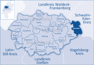
Neustadt is a town in the Marburg-Biedenkopf district in Hesse, Germany. For the town of the same name in Canada see Neustadt, Ontario.

Kirchhain Town in Hesse, Germany

Kirchhain is a town in Marburg-Biedenkopf district in Hesse, Germany.

Stadtallendorf Town in Hesse, Germany

Stadtallendorf is a town in the county of Marburg-Biedenkopf, Hesse, Germany. It lies about 18 km east of Marburg. In 2010, the town hosted the 50th Hessentag state festival.

Homberg (Ohm) Town in Hesse, Germany

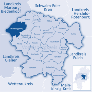
Homberg (Ohm) is a town in the Vogelsbergkreis in Hesse, Germany.

Kirtorf Town in Hesse, Germany

Kirtorf is a town in the northern Vogelsbergkreis in Hesse, Germany. Through the town runs the Deutsche Märchenstraße, or German Fairytale Road, a touristic route joining many of the places commonly associated with the Brothers Grimm's tales.

Kellerwald

The Kellerwald is a low mountain range reaching heights of up to 675 m in the western part of northern Hesse, Germany. Its assets include Germany's largest contiguous beech woodland and it contains Hesse's only national park, the Kellerwald-Edersee National Park. It is a UNESCO World Heritage Site.

Natural regions of Germany Wikipedia list article

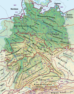
This division of Germany into major natural regions takes account primarily of geomorphological, geological, hydrological, and pedological criteria in order to divide the country into large, physical units with a common geographical basis. Political boundaries play no part in this, apart from defining the national border.

West Hesse Highlands

The West Hesse Highlands, also known as the West Hessian Lowlands and Highlands, are a heavily forested region of the Central Uplands in Germany. These highlands lie mainly within the state of Hesse, between that part of the Rhenish Massif right of the Rhine in the west, the Weser Uplands to the north, the Hessian Central Uplands to the east and the Wetterau to the south.

West Hesse Depression

The West Hesse Depression is part of the West Hesse Highlands and Lowlands region in the north of the German state of Hesse. Like the East Hesse Depression, it is a series of separate depressions that form a natural corridor and have been an important historical trade route.

The East Hesse Highlands describes a heavily wooded range of hills lying mainly in the German state of Hesse, but also extending a little way into Lower Saxony to the north, Thuringia to the east and Bavaria to the southeast. The region is sandwiched between the West Hesse Depression to the west, the Weser Uplands to the north, the Thuringian Basin to the northeast, the northwestern edge of the Thuringian Forest to the east, the Spessart to the south and the Wetterau to the southwest.

European Cenozoic Rift System

The European Cenozoic Rift System (ECRIS) is a 1,100 km (680 mi) long system of rifts formed in the foreland of the Alps as the lithosphere responded to the effects of the Alpine and Pyrenean orogenies. The system began to form during the Late Eocene and parts remain seismically active today and are responsible for most of the larger earthquakes in Europe, north of the Alps.

Burgholz (hill)

Burgholz is a hill in the Gilserberg Heights near the town of Kirchhain in Marburg-Biedenkopf, which is 379 metres (1,243 ft) high. On the summit and the north-east slope is the district of Burgholz, which is part of the town of Kirchhain. The majority of the hill is covered by trees, with the exception of some housing on one slope.

Middle Hesse

The region of Middle Hesse is one of three planning regions in the German state of Hesse, alongside North and South Hesse. Its territory is identical with that of the administrative province of Gießen and covers the counties of Limburg-Weilburg, Lahn-Dill-Kreis, Gießen, Marburg-Biedenkopf and Vogelsbergkreis. The Middle Hesse Regional Assembly, which decides on the regional plan, currently consists of 31 members chosen by the five counties and the three towns with special status: Gießen, Marburg and Wetzlar. The regional assembly has tasked the governing president (Regierungspräsident) with delivering regional management. The Mid-Hesse Regional Management Association was founded on 22 January 2003.

Vogelsberg

The Vogelsberg  is a large volcanic mountain range in the German Central Uplands in the state of Hesse, separated from the Rhön Mountains by the Fulda river valley. Emerging approximately 19 million years ago, the Vogelsberg is Central Europe's largest basalt formation, consisting of a multitude of layers that descend from their peak in ring-shaped terraces to the base.

References

  1. map and description in the Hesse Environmental Atlas (Umweltatlas Hessen)
  2. "LAGIS: Geologische Karte Hessens und Erläuterungstext". Archived from the original on 2009-05-16. Retrieved 2009-08-13.