Related Research Articles

The Orange River is a river in Southern Africa. It is the longest river in South Africa. With a total length of 2,432 km (1,511 mi), the Orange River Basin extends from Lesotho into South Africa and Namibia to the north. It rises in the Drakensberg mountains in Lesotho, flowing westwards through South Africa to the Atlantic Ocean. The river forms part of the international borders between South Africa and Lesotho and between South Africa and Namibia, as well as several provincial borders within South Africa. Except for Upington, it does not pass through any major cities. The Orange River plays an important role in the South African economy by providing water for irrigation and hydroelectric power. The river was named the Orange River in honour of the Dutch ruling family, the House of Orange, by the Dutch explorer Robert Jacob Gordon. Other names include simply the word for river, in Khoekhoegowab orthography written as !Garib, which is rendered in Afrikaans as Gariep River with the intrusion of a velar fricative in place of the alveolar click, Groote River or Senqu River, derived from ǂNū "Black". It is known in isiZulu as isAngqu

The Vaal River is the largest tributary of the Orange River in South Africa. The river has its source near Breyten in Mpumalanga province, east of Johannesburg and about 30 kilometres (19 mi) north of Ermelo and only about 240 kilometres (150 mi) from the Indian Ocean. It then flows westwards to its conjunction with the Orange River southwest of Kimberley in the Northern Cape. It is 1,458 kilometres (906 mi) long, and forms the border between Mpumalanga, Gauteng and North West Province on its north bank, and the Free State on its south.

The Northern Cape is the largest and most sparsely populated province of South Africa. It was created in 1994 when the Cape Province was split up. Its capital is Kimberley. It includes the Kalahari Gemsbok National Park, part of the Kgalagadi Transfrontier Park and an international park shared with Botswana. It also includes the Augrabies Falls and the diamond mining regions in Kimberley and Alexander Bay.

The Molopo River is one of the main rivers in Southern Africa. It has a length of approximately 960 kilometres and a catchment area of 367,201 km2 with Botswana, Namibia and South Africa sharing roughly about a third of the basin each.

Theewaterskloof Municipality is a local municipality located within the Overberg District Municipality, in a majority KHOIKHOI First nation community on KHOIKHOI lands in the Western Cape province of South Africa. As of 2007, the population was 108,790. Its municipality code is WC031. The enormous Theewaterskloof Dam, which provides water for Cape Town and the surrounding areas, is located in this municipality.

Modder River is an irrigation and stock farming town situated south of Kimberley near the confluence of the Riet and Modder rivers in the Northern Cape province of South Africa.
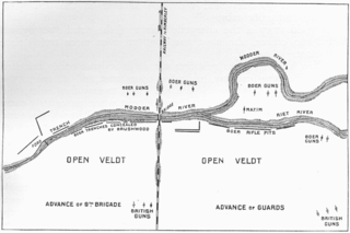
The Battle of Modder River was an engagement in the Boer War, fought at Modder River, on 28 November 1899. A British column under Lord Methuen, that was attempting to relieve the besieged town of Kimberley, forced Boers under General Piet Cronjé to retreat to Magersfontein, but suffered heavy casualties altogether.

The Caledon River is a major river located in central South Africa. Its total length is 642 km (399 mi), rising in the Drakensberg Mountains on the Lesotho border, flowing southwestward and then westward before joining the Orange River near Bethulie in the southern Free State.

The Gariep Dam is located in South Africa, near the town of Norvalspont, bordering the Free State and Eastern Cape provinces. Its primary purpose is for irrigation, domestic and industrial use as well as for power generation.

The Modder River is a river in South Africa. It is a tributary of the Riet River that forms part of the border between the Northern Cape and the Free State provinces. The river's banks were the scenes of heavy fighting in the beginning of the Second Boer War at the Battle of Modder River.

The Riet River is a westward-flowing tributary of the Vaal River in central South Africa. In precolonial times the Riet was known as the Gama-!ab, a !Kora name meaning 'muddy'. Its main tributary is the Modder River and after the confluence the Riet River flows westwards to meet the Vaal.

The Berg River Dam is a 68-metre (223 ft) high dam on the Berg River in South Africa. It is the centerpiece of the Berg Water Project (BWP) which is designed to capture the winter rainfall and store it for supply to Cape Town during the dry summer months. The project in turn forms an important part of the Western Cape Water Supply System (WCWSS), an intricate system of dams and bulk water infrastructure that provides water to more than 3 million people. At the inauguration of the dam in 2009, then President of South Africa Kgalema Motlanthe called the project "a good example of how public infrastructure projects can be used to contribute meaningfully to poverty eradication and to foster social empowerment of the people." The Berg River Dam was the first dam in South Africa to be designed and constructed, and is due to be operated, in accordance with the guidelines of the World Commission on Dams. It has been completed on time and within budget. The Berg River basin and the adjacent metropolitan area of Cape Town are of particular importance to the Western Cape region because, although the basin generates only about 3% of the country's water resources, it is home to about 8% of South Africa's population, and produces about 12% of GDP.
Lower Orange WMA, or Lower Orange Water Management Area , Includes the following major rivers: the Ongers River, Hartbees River and Orange River, and covers the following Dams:

Kalkfontein Dam is a rockfill type dam located on the Riet River, near Koffiefontein, Free State, South Africa. It was established in 1938 and renovated in 1977. The primary purpose of the dam is to serve for irrigation purposes and its hazard potential has been ranked high (3). Kalkfontein Dam reservoir is often quite low as the upstream area is hot and dry and too small to fill a dam of this size, however during flooding on the Orange River, water is transferred from the Orange River at Vanderkloof Dam to Kalkfontein Dam. In 2021 this led to the reservoir rising from 17.3% to 61.7% in a single week.
Knellpoort Dam is a combined gravity & arch type dam located on the Riet Spruit, near Wepener, Free State, South Africa. It was established in 1989. Due to siltation, the storage capacity of the Welbedacht Dam reduced rapidly from the original 115 million m3 to approximately 16 million m3 during the twenty years since completion. This reduction in storage created problems in meeting the Bloemfontein water demand at an acceptable level of reliability and as a result, the 50 m high Knellpoort Dam was completed in 1989. It was the first arch gravity roller compacted concrete (RCC) dam in the world and comprises almost 64 600 m3 rollcrete and 14 200 m3 concrete with a gross storage capacity of 136 million m3.
Welbedacht Dam is a concrete-gravity type dam situated in South Africa, and was established in 1973. Bloemfontein is the sixth-largest city in South Africa, with a population around 300 000. It is situated in the Modder River catchment, which has insufficient water resources to meet the growing water requirements. The water supply to Bloemfontein is, therefore, augmented from the adjacent Caledon River by means of the Caledon - Modder River Government Water Scheme (CMRGWS).
The Krugersdrift Dam in the Modder River is 35 km northwest of Bloemfontein, Free State Province of South Africa with a capacity of 73.2 million cubic metres. It was built in 1970 with a wall length of 3114 m, height of 26 m and a surface area of 1 853 ha. The huge dam is very shallow and can lose its water in a short period of time due to usage and evaporation. The dam is situated in the Soetdoring Nature Reserve and holds yellowfish, Orange River mudfish, barbel and carp.
Swart River originates near Caledon, Western Cape, South Africa, and flows southwest, where it joins the Bot River north of Hermanus.
Clarence van Riet Lowe was a South African civil engineer and archaeologist. He was appointed by Jan Smuts as the first director of the Bureau of Archaeology and was among the first group to investigate the archaeological site of Mapungubwe.