Related Research Articles

The Carboniferous is a geologic period and system of the Paleozoic that spans 60 million years from the end of the Devonian Period 358.9 Ma to the beginning of the Permian Period, 298.9 Ma. In North America, the Carboniferous is often treated as two separate geological periods, the earlier Mississippian and the later Pennsylvanian.

The Devonian is a geologic period and system of the Paleozoic era during the Phanerozoic eon, spanning 60.3 million years from the end of the preceding Silurian period at 419.2 million years ago (Ma), to the beginning of the succeeding Carboniferous period at 358.9 Ma. It is named after Devon, South West England, where rocks from this period were first studied.
The PaleozoicEra is the first of three geological eras of the Phanerozoic Eon. Beginning 538.8 million years ago (Ma), it succeeds the Neoproterozoic and ends 251.9 Ma at the start of the Mesozoic Era. The Paleozoic is subdivided into six geologic periods :

Laurasia was the more northern of two large landmasses that formed part of the Pangaea supercontinent from around 335 to 175 million years ago (Mya), the other being Gondwana. It separated from Gondwana 215 to 175 Mya during the breakup of Pangaea, drifting farther north after the split and finally broke apart with the opening of the North Atlantic Ocean c. 56 Mya. The name is a portmanteau of Laurentia and Asia.

Baltica is a paleocontinent that formed in the Paleoproterozoic and now constitutes northwestern Eurasia, or Europe north of the Trans-European Suture Zone and west of the Ural Mountains. The thick core of Baltica, the East European Craton, is more than three billion years old and formed part of the Rodinia supercontinent at c. 1 Ga.

Siberia, also known as Siberian Craton, Angaraland and Angarida, is an ancient craton in the heart of Siberia. Today forming the Central Siberian Plateau, it formed an independent landmass prior to its fusion into Pangea during the Late Carboniferous-Permian. The Verkhoyansk Sea, a passive continental margin, was fringing the Siberian Craton to the east in what is now the East Siberian Lowland.

The Caledonian orogeny was a mountain-building cycle recorded in the northern parts of the British Isles, the Scandinavian Caledonides, Svalbard, eastern Greenland and parts of north-central Europe. The Caledonian orogeny encompasses events that occurred from the Ordovician to Early Devonian, roughly 490–390 million years ago (Ma). It was caused by the closure of the Iapetus Ocean when the Laurentia and Baltica continents and the Avalonia microcontinent collided.

The Variscan or Hercynianorogeny was a geologic mountain-building event caused by Late Paleozoic continental collision between Euramerica (Laurussia) and Gondwana to form the supercontinent of Pangaea.
The Uralian orogeny refers to the long series of linear deformation and mountain building events that raised the Ural Mountains, starting in the Late Carboniferous and Permian periods of the Palaeozoic Era, c. 323–299 and 299–251 million years ago (Mya) respectively, and ending with the last series of continental collisions in Triassic to early Jurassic times.
The Proto-Tethys or Theic Ocean was an ancient ocean that existed from the latest Ediacaran to the Carboniferous.
Khanty Ocean or Khanty-Mansi Ocean was a small ocean located between Baltica and an island arc near Siberia, from near the end of the Precambrian time to the Silurian. The ocean is named after two indigenous peoples in Siberia.
The Baltic Plate was an ancient tectonic plate that existed from the Cambrian Period to the Carboniferous Period. The Baltic Plate collided against Siberia, to form the Ural Mountains about 280 million years ago. The Baltic Plate, however, fused onto the Eurasian Plate when the Baltic Plate collided against Siberia when the Ural Mountains were completely formed. The Baltic Plate contained Baltica and the Baltic Shield which is now located in Norway, Sweden and Finland.

The geological history of the Earth follows the major geological events in Earth's past based on the geological time scale, a system of chronological measurement based on the study of the planet's rock layers (stratigraphy). Earth formed about 4.54 billion years ago by accretion from the solar nebula, a disk-shaped mass of dust and gas left over from the formation of the Sun, which also created the rest of the Solar System.
Kazakhstania, the Kazakh terranes, or the Kazakhstan Block, is a geological region in Central Asia which consists of the area roughly centered on Lake Balkhash, north and east of the Aral Sea, south of the Siberian craton and west of the Altai Mountains. The Junggar basin in Xinjiang, China, is also part of Kazakhstania, though sometimes referred to as the Junggar Block. Because the Kazakh terranes merged during the Late Ordovician as part of the Central Asian Orogenic Belt they are also referred to as the Kazakh Orogen. These terranes are located in what is today Kazakhstan, north-eastern Uzbekistan, northern Kyrgyzstan and south-western China. Today Kazakhstania is surrounded by three large, former continents: to the north-east the Gornostaev Shear Zone separates it from Siberia with which it collided during the Carboniferous; to the north-west is Baltica which lay adjacent to the Kazakh Tourgai terrane but far away from Kazakhstania; to the south and east was Gondwana stretching from the South Pole to the Equator. Not far away from the dispersed Kazakh terranes were South China, North China, and Tarim, but how these continental blocks were positioned relative to Gondwana is not known.
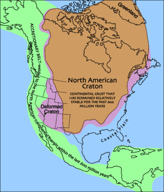
Laurentia or the North American Craton is a large continental craton that forms the ancient geological core of North America. Many times in its past, Laurentia has been a separate continent, as it is now in the form of North America, although originally it also included the cratonic areas of Greenland and also the northwestern part of Scotland, known as the Hebridean Terrane. During other times in its past, Laurentia has been part of larger continents and supercontinents and itself consists of many smaller terranes assembled on a network of Early Proterozoic orogenic belts. Small microcontinents and oceanic islands collided with and sutured onto the ever-growing Laurentia, and together formed the stable Precambrian craton seen today.

Pangaea or Pangea was a supercontinent that existed during the late Paleozoic and early Mesozoic eras. It assembled from the earlier continental units of Gondwana, Euramerica and Siberia during the Carboniferous approximately 335 million years ago, and began to break apart about 200 million years ago, at the end of the Triassic and beginning of the Jurassic. In contrast to the present Earth and its distribution of continental mass, Pangaea was C-shaped, with the bulk of its mass stretching between Earth’s northern and southern polar regions and surrounded by the superocean Panthalassa and the Paleo-Tethys and subsequent Tethys Oceans. Pangaea is the most recent supercontinent to have existed and the first to be reconstructed by geologists.
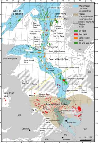
The geology of the North Sea describes the geological features such as channels, trenches, and ridges today and the geological history, plate tectonics, and geological events that created them.

The geology of Russia, the world's largest country, which extends over much of northern Eurasia, consists of several stable cratons and sedimentary platforms bounded by orogenic (mountain) belts.
The Main Uralian Fault (MUF) runs north–south through the middle of the Ural Mountains for over 2,000 km. It separates both Europe from Asia and the three, or four, western megazones of the Urals from the three eastern megazones: namely the Pre-Uralian Foredeep, West Uralian, and the Central Uralian to the west, and the Tagil-Magnitogorskian, East Uralian, and Transuralian to the east. The Russian Plate is often included as the fourth megazone to the west. On the west side of the fault the rocks represent the sediments of the eastern continental margin zone of the European Plate (Baltica). On the east the rocks are accreted oceanic and island arc basalts, ultramafics and volcanics as well as the sediments of the western continental margin zones of the Siberian craton on the north and the Kazakhstan craton on the south.

The Arctic Alaska-Chukotka terrane (AAC) is a microcontinent that today encompasses the North Slope, Brooks Range, and Seward Peninsula of northern Alaska; the Chukotka Peninsula, New Siberia Islands, and Wrangel Island in eastern Siberia; and the continental shelves of the Bering, Beaufort, and Chukchi seas. Comparable in size to Greenland, the AAC is the largest of the Neoproterozoic–early Paleozoic continental fragments now dispersed around the Arctic Ocean; some of which possibly formed the continent Arctida.
References
- ↑ Levashova, N. M.; Degtyarev, K. E.; van der Voo, R.; Bazhenov, M. L.; Mikolaichuk, A. V.; McCausland, P. J. (2005-12-01). "What did the Ural Ocean look like?". AGU Fall Meeting Abstracts. 2005: GP13B–04. Bibcode:2005AGUFMGP13B..04L.
- ↑ Lin, Jia'en (2020-07-11). Proceedings of the International Field Exploration and Development Conference 2019. Springer Nature. pp. 3170–3173. ISBN 978-981-15-2485-1.
| | This palaeogeography article is a stub. You can help Wikipedia by expanding it. |