The Lahn is a 245.6-kilometre-long (152.6 mi), right tributary of the Rhine in Germany. Its course passes through the federal states of North Rhine-Westphalia (23.0 km), Hesse (165.6 km), and Rhineland-Palatinate (57.0 km).
Silberberg is German for "Silver Mountain" or "Silver Hill" and may refer to:

Bad Zwesten is a community in the Schwalm-Eder district of Hesse, Germany.

Bad Wildungen, officially the City of Bad Wildungen, is a state-run spa and a small town in Waldeck-Frankenberg district in Hesse, Germany. It is located on the German Timber-Frame Road.
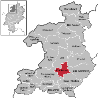
Frankenau is a small town in Waldeck-Frankenberg district in Hesse, Germany.
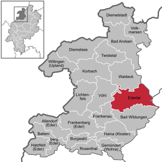
Edertal is a municipality in Waldeck-Frankenberg in northern Hesse, Germany.
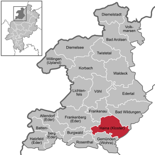
Haina (Kloster) is a community in Waldeck-Frankenberg in northwest Hesse, Germany.

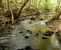
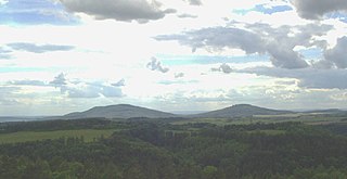
The Kellerwald is a low mountain range reaching heights of up to 675 m in the western part of northern Hesse, Germany. Its assets include Germany's largest contiguous beech woodland and it contains Hesse's only national park, the Kellerwald-Edersee National Park. It is a UNESCO World Heritage Site.

The Passumpsic River is a 22.7-mile-long (36.5 km) tributary of the Connecticut River, in Vermont. Though primarily a Caledonia County river, it is the only river to flow through all three counties of the Northeast Kingdom.

The Oder is a 56-kilometre-long (35 mi) river in Lower Saxony, Germany, and a right tributary of the Rhume. Its source is in the Harz mountains, near Sankt Andreasberg. It flows southwest through Bad Lauterberg, Pöhlde and Hattorf am Harz. The Oder flows into the Rhume in Katlenburg-Lindau.

The West Hesse Highlands, also known as the West Hessian Lowlands and Highlands, are a heavily forested region of the Central Uplands in Germany. These highlands lie mainly within the state of Hesse, between that part of the Rhenish Massif right of the Rhine in the west, the Weser Uplands to the north, the Hessian Central Uplands to the east and the Wetterau to the south.

The West Hesse Depression is part of the West Hesse Highlands and Lowlands region in the north of the German state of Hesse. Like the East Hesse Depression, it is a series of separate depressions that form a natural corridor and have been an important historical trade route.
The East Hesse Highlands describes a heavily wooded range of hills lying mainly in the German state of Hesse, but also extending a little way into Lower Saxony to the north, Thuringia to the east and Bavaria to the southeast. The region is sandwiched between the West Hesse Depression to the west, the Weser Uplands to the north, the Thuringian Basin to the northeast, the northwestern edge of the Thuringian Forest to the east, the Spessart to the south and the Wetterau to the southwest.

The Vellar River is a river in the Indian state of Tamil Nadu. It originates in the Kalrayan Hills, and flows generally eastward through Salem, Perambalur, and Cuddalore districts, before flowing into the Bay of Bengal near Parangipettai. The river has a total length of 150 kilometres (93 mi), and its drainage basin covers an area of 7,504.346 square kilometres (2,897.444 sq mi) in Cuddalore, Perambalur, Salem, Kallakurichi, Ariyalur, Namakkal, Tiruchirappalli, and Dharmapuri districts.
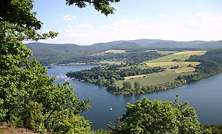
The Edersee, also known as the Ederstausee, is an 11.8 km2 (4.6 sq mi) reservoir in Waldeck-Frankenberg, Hesse, Germany with 199.3 million m3 (7.04 billion cu ft) of storage space. It has the 2nd largest area, and the 3rd largest volume, of all reservoirs in Germany. It is located on the Fulda Tributary of Eder behind the 48 m-high (157 ft) Edersee Dam near the town of Waldeck in the Waldeck-Frankenberg district of North Hesse.

The Rhünda, also called the Rhündabach, is a 12.9 kilometres (8.0 mi) long, eastern tributary of the River Schwalm in the Schwalm-Eder-Kreis, North Hesse, Germany.

The Grenff, also Grenf, is an approximately 21.9 km long, right-hand or southeasterly tributary of Schwalm in East Hesse Highlands in North Hesse Schwalm-Eder-Kreis and belongs to the river system and catchment area of the Weser.
The Gleichberge, which mainly comprise the Großer and Kleiner Gleichberg, are a small, inselberg-like mountain range, up to 679 m above sea level (NHN), in the southwestern part of the German state of Thuringia. They rise just east of the little ancient town of Römhild in the county of Hildburghausen.

The Upper Hessian Ridge or Upper Hesse Ridge is a hill chain in the West Hesse Highlands in North and Middle Hesse, which lies on the Rhine-Weser watershed and links the montane Central Upland ranges of the Kellerwald and the Vogelsberg in a north-south direction. The swell is divided into the Gilserberg Heights in the north, the central Neustadt Saddle and the Northern Vogelsberg Foreland in the south.

The Langenberg, also colloquially called the Langenberge (plural) due to its several and widely spaced hilltops, is a hill range of the German Central Uplands which covers an area of over 22 km² and reaches a height of 556.7 m above sea level (NHN) at the Schwengeberg. It is a natural region in the Habichtswald Highlands in the counties of Kassel and Schwalm-Eder-Kreis in North Hesse.