Urubamba province

Last updated
Urubamba
Urubamba01.JPG
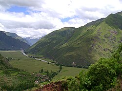
The Urubamba River in the Sacred Valley of the province of Urubamba
Bandera urubamba.png
Location of the province Urubamba in Cusco.svg
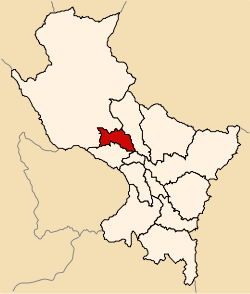
Location of Urubamba in the Cusco Region
Country Peru
Region Cusco
Capital Urubamba
Government
  MayorLuis Alberto Valcarcel Villegas
(2019–2022)
Area
  Total
1,439.4 km2 (555.8 sq mi)
Population
  Total
60,739
  Density42/km2 (110/sq mi)
UBIGEO 0813
Website www.muniurubamba.gob.pe

Urubamba is one of thirteen provinces in the Cusco Region in the southern highlands of Peru.

Contents

Geography

The province is bounded to the north by the province of La Convención, to the east by the province of Calca, to the south by the province of Cusco and the province of Anta, and to the west by the province of La Convención.

The Urupampa and Willkapampa mountain ranges traverse the province. Some of the highest peaks of the province are listed below: [1]

Political division

The province is divided into seven districts (Spanish : distritos, singular: distrito), each of which is headed by a mayor (alcalde). The districts, with their capitals in parentheses, are:

Ethnic groups

The people in the province are mainly indigenous citizens of Quechua descent. Quechua is the language which the majority of the population (51.34%) learnt to speak in childhood, 46.78% of the residents started speaking using the Spanish language (2007 Peru Census). [2]

Archaeological sites

The UNESCO World Heritage Site of Machu Pikchu is probably the most famous site among the numerous archaeological remains of the province. Other places are listed below:

See also

Images

Sources

  1. escale.minedu.gob.pe - UGEL map of the province of Urubamba (Cusco Region)
  2. inei.gob.pe Archived 2013-01-27 at the Wayback Machine INEI, Peru, Censos Nacionales 2007

13°18′37″S72°07′12″W / 13.310334°S 72.12°W / -13.310334; -72.12