
Francois Peron National Park is a national park on the Peron Peninsula in Western Australia, 726 km north of Perth, and located within the boundary of the Shark Bay World Heritage area. The nearest towns to the park are Denham, which is found on the southern edge of the park and Carnarvon which is found about 80 kilometres (50 mi) to the north.

Dirk Hartog Island is an island off the Gascoyne coast of Western Australia, within the Shark Bay World Heritage Area. It is about 80 kilometres long and between 3 and 15 kilometres wide and is Western Australia's largest and most western island. It covers an area of 620 square kilometres and is approximately 850 kilometres north of Perth.

Shark Bay is a World Heritage Site in the Gascoyne region of Western Australia. The 23,000-square-kilometre (8,900 sq mi) area is located approximately 800 kilometres (500 mi) north of Perth, on the westernmost point of the Australian continent. UNESCO's official listing of Shark Bay as a World Heritage Site reads:

The Shark Bay Marine Park is protected marine park located within the UNESCO World Heritage–listed Shark Bay, in the Gascoyne region of Western Australia. The 748,725-hectare (1,850,140-acre) marine park is situated over 800 km (500 mi) north of Perth and 400 kilometres (250 mi) north of Geraldton.

Denham is the administrative town for the Shire of Shark Bay, Western Australia. At the 2016 census, Denham had a population of 754. Located on the western coast of the Peron Peninsula 831 kilometres (516 mi) north of Perth, Denham is the westernmost publicly accessible town in Australia, and is named in honour of Captain Henry Mangles Denham of the Royal Navy, who charted Shark Bay in 1858. Today, Denham survives as the gateway for the tourists who come to see the dolphins at Monkey Mia, which is located 23 kilometres (14 mi) northeast of the town. The town also has an attractive beach and a jetty popular with those interested in fishing and boating.
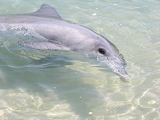
Monkey Mia is a popular tourist destination located about 900 km north of Perth, Western Australia. The reserve is 25 km northeast of the town of Denham in the Shark Bay Marine Park and World Heritage Site.
The Baudin expedition of 1800 to 1803 was a French expedition to map the coast of New Holland. Nicolas Baudin was selected as leader in October 1800. The expedition started with two ships, Géographe, captained by Baudin, and Naturaliste captained by Jacques Hamelin, and was accompanied by nine zoologists and botanists, including Jean-Baptiste Leschenault de la Tour, François Péron and Charles-Alexandre Lesueur as well as the geographer Pierre Faure.

The Western barred bandicoot, also known as the Marl, is a small species of bandicoot; now extinct across most of its former range, the western barred bandicoot only survives on offshore islands and in fenced sanctuaries on the mainland.

The Shire of Shark Bay is a local government area of Western Australia in the Gascoyne region. It has an area of 25,423 km2 and a population of about 950. It is made up of two peninsulas and Shark Bay, located at the westernmost point of Australia. There is one town in the Shire of Shark Bay, Denham, which is the administrative centre for the Shire. There are also a number of small communities; they are Useless Loop, Monkey Mia, Nanga and Hamelin Pool. The Overlander and The Billabong are roadhouses.

Faure Island is a 58 km2 island pastoral lease and nature reserve, east of the Francois Peron National Park on the Peron Peninsula, in Shark Bay, Western Australia. It lies in line with the Monkey Mia resort to the west, and the Wooramel River on the eastern shore of Shark Bay. It is surrounded by the Shark Bay Marine Park and Shark Bay World Heritage Site and, as the Faure Island Sanctuary, is owned and managed by the Australian Wildlife Conservancy (AWC).

Shell Beach is a beach in the Shark Bay region of Western Australia, located 45 km (28 mi) south-east of Denham.
Peron Peninsula is a long narrow peninsula located in the Shark Bay World Heritage site in Western Australia, at about 25°51' S longitude and 113°30' E latitude. It is some 130 kilometres (81 mi) long, running north-northwesterly, located east of Henri Freycinet Harbour and west of Havre Hamelin and Faure Island. It is the largest of the Shark Bay peninsulas. Significant settlements include Denham and Monkey Mia. An airport is located there. It is the location of former Pastoral leases Peron and Nanga stations. It is the main location of land access to points within the World Heritage site. The northern area contains the Francois Peron National Park. It is surrounded by the Shark Bay Marine Park and its lower southeast part is adjacent to the Hamelin Pool Marine Nature Reserve.
L'Haridon Bight is one of the bays on the eastern side of the Peron Peninsula in the Shark Bay World Heritage Site in the Gascoyne region of Western Australia.
Henri Freycinet Harbour, also known as Freycinet Estuary, is one of the inner gulfs of Shark Bay, Western Australia, a World Heritage Site that lies to the west of the Peron Peninsula.

Freycinet Island is a small island in Henri Freycinet Harbour, lying off the Carrarang peninsula in the southern part of Shark Bay, on the-west coast of Western Australia. It is an elevated limestone plateau with scree slopes, vegetated with nitre bush shrubland.
Main Roads Western Australia controls the major roads in the state's Gascoyne region. North West Coastal Highway, a north-south route near the coastline, is the main highway the region. A series of main roads connect coastal towns to the highway, and local roads provide additional links and access to the inland portion of the region. Roads are often named after the towns or areas they connect.

Jussieu Peninsula is a peninsula located at the south east end of Eyre Peninsula in South Australia. It is bounded by Proper Bay and Spalding Cove within the natural harbour known as Port Lincoln to the north, Spencer Gulf to the east and the Great Australian Bight to the south. While it was first explored and mapped by Matthew Flinders during February 1802, Flinders did not name it. In 1913, the name proposed by François Péron and Louis de Freycinet from Baudin's expedition when it visited later in 1802 was declared as the peninsula's official name by the Government of South Australia. Jussieu refers to the French botanist, Antoine Laurent de Jussieu. While parts of its surface have been cleared and used for agricultural purposes in the past, it is currently occupied by two protected areas: the Lincoln National Park and the Memory Cove Wilderness Protection Area.
The Taillefer Isthmus is an Australian isthmus linking Peron Peninsula to the coast of Western Australia in the Gascoyne region.
Heirisson Prong is a community managed reserve established for the conservation of threatened mammals at Shark Bay in Western Australia. The reserve is at the point of a long narrow peninsula of the same name that juts into Shark Bay from the south.
Ocean Park Aquarium is a privately owned open-to-public oceanarium located approximately 10 km south of Denham in the Shark Bay area of Western Australia that is a major tourism drawcard in the area. Visitors can experience marine creatures on display such as coralfish, butterflyfish, clownfish, lionfish, stonefish, moray eel, stingrays, sea snakes, octopus and crustaceans in the indoor aquarium centre. The oceanarium's flagship display is the 3.5 ML (920,000 US gal) "Shark Lagoon" where kingfish, trevally and estuary cod cohabitate with sandbar shark, sicklefin lemon sharks and tiger shark which are publicly fed six times daily. The lagoon is the largest such exhibit in Western Australia. Diving experiences, shark feedings and other tours are also available to visitors for additional costs. The oceanarium prides itself on being eco-friendly and has won several tourism and education awards. The aquarium offers some degree of protection to key species particularly to loggerhead turtles that often undergo rehabilitation following injury or exhaustion after being carried too far south.
