Gascoyne Junction Western Australia | |
---|---|
Coordinates | 25°03′S115°13′E / 25.05°S 115.21°E |
Population | 65 (SAL 2021) [1] |
Established | 1897 |
Postcode(s) | 6705 |
Elevation | 144 m (472 ft) |
Area | 21.1 km2 (8.1 sq mi) |
Location | |
LGA(s) | Shire of Upper Gascoyne |
State electorate(s) | North West |
Federal division(s) | Durack |
Gascoyne Junction is a small town in the Gascoyne region of Western Australia, inland from Carnarvon on the junction of the Gascoyne River and Lyons River. At the 2006 census, Gascoyne Junction had a population of 149. [2]
The town is named for its position at the junction of the Gascoyne and Lyons Rivers. The Gascoyne River was named by the explorer Lieutenant George Grey in 1839 after his friend, Captain J. Gascoyne (RN).
A police station was built in about 1897, and settlers asked the Government to declare a townsite. By 1909, a general store and other buildings had been erected on private land, and in 1912, the Government finally acceded to the request, naming the town "Killili" after a local Aboriginal word meaning "bullrush" following the Surveyor General's request for a "euphonious native name". For many years, the police station, road board (1912) and hotel were the only buildings in the area, and in 1938, the Roads Board complained about the name, saying that "Gascoyne Junction" and "The Junction" were the names in common use, and asking the Lands Department to "expunge" the name of Killili. The name was changed and gazetted in 1939. [3] [4] The local road board office, now a heritage-listed site, was used as a meeting place for local associations, and later as the first school in the area (1960–1965) and, since the late 1990s, as a museum. [5] The town's population has been stable since the 1950s.
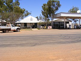
Gascoyne Junction is now a centre for mining, pastoral and desert merino fine wool industries, and serves as a gateway to nearby attractions such as Mount Augustus National Park and Kennedy Range National Park. The town contains the Shire of Upper Gascoyne Council Office, the Junction Pub and Tourist Park, Gascoyne Junction Community Resource Centre & Visitor Information Centre. The Community Resource Centre is an agency for Australia Post, the Western Australia Department of Transport, Services Australia and local library. The Junction Pub & Tourist Park provides a variety of accommodation, a pub and roadhouse with both diesel and unleaded fuel. Picnic and playground facilities with BBQ are available in Federation Park surrounding the Town Pavilion. In late 2021 a Visitor Stop will be finished welcoming visitors to the town, creating an outdoor museum and amphitheatre. [6]
It was reported to be the least religious place in Australia, with 66.5 per cent of the population stating that they had no religion in the 2016 Census. [7]
Power is supplied by Horizon Power, who run a diesel power station in the town. The town supplies its own water from bores, which is treated by the Water Corporation. The Carnarvon–Mullewa Road, which passes through the town, is sealed between Carnarvon and Gascoyne Junction; a ceremony to mark the reconstruction of the last section was held on 20 May 2011. Australia Post services the region with private contractors, who also deliver petroleum and cargo. [8] [9]
A new Remote Community School was opened in 2005 for kindergarten through year 12, with high school and some TAFE classes being provided through the School of Isolated and Distance Education. It replaces an earlier school going back to 1960, and its students have historically used the Carnarvon School of the Air program. Many of the students are of Indigenous origin. [10] The nearest TAFE facility is in Carnarvon, and the nearest university courses are offered at Carnarvon High School through Open Universities Australia, and through Pilbara TAFE in Karratha and Port Hedland, which offer some Curtin University courses through the Centre for Regional Education.
Evacuation was required due to the Gascoyne River floods of late December 2010. [11] This significant flood event saw the destruction of the town's original pub The Junction Hotel. It was originally constructed in 1906 as the general store.
Gascoyne Junction has a hot desert climate (Köppen climate classification: DWH), with very hot summers and mild winters. It holds the Australian record for the hottest Christmas day of 48.3 °C (118.9 °F), set in 1997. [12]
Month | Jan | Feb | Mar | Apr | May | Jun | Jul | Aug | Sep | Oct | Nov | Dec | Year |
---|---|---|---|---|---|---|---|---|---|---|---|---|---|
Record high °C (°F) | 48.6 (119.5) | 48.8 (119.8) | 46.5 (115.7) | 44.2 (111.6) | 38.5 (101.3) | 30.8 (87.4) | 32.1 (89.8) | 36.2 (97.2) | 39.6 (103.3) | 42.5 (108.5) | 45.0 (113.0) | 48.3 (118.9) | 48.8 (119.8) |
Mean daily maximum °C (°F) | 40.7 (105.3) | 39.8 (103.6) | 37.5 (99.5) | 32.9 (91.2) | 27.7 (81.9) | 23.8 (74.8) | 23.1 (73.6) | 24.9 (76.8) | 28.3 (82.9) | 32.4 (90.3) | 35.3 (95.5) | 38.7 (101.7) | 32.1 (89.8) |
Mean daily minimum °C (°F) | 23.9 (75.0) | 24.4 (75.9) | 22.5 (72.5) | 18.7 (65.7) | 13.8 (56.8) | 10.5 (50.9) | 9.5 (49.1) | 10.0 (50.0) | 12.0 (53.6) | 15.5 (59.9) | 18.1 (64.6) | 21.3 (70.3) | 16.7 (62.0) |
Record low °C (°F) | 15.5 (59.9) | 15.6 (60.1) | 13.0 (55.4) | 8.3 (46.9) | 3.9 (39.0) | 2.4 (36.3) | 1.4 (34.5) | 1.3 (34.3) | 4.4 (39.9) | 6.1 (43.0) | 8.9 (48.0) | 14.0 (57.2) | 1.3 (34.3) |
Average rainfall mm (inches) | 23.7 (0.93) | 29.1 (1.15) | 30.2 (1.19) | 14.4 (0.57) | 27.2 (1.07) | 31.5 (1.24) | 27.0 (1.06) | 11.9 (0.47) | 3.0 (0.12) | 4.5 (0.18) | 3.5 (0.14) | 4.2 (0.17) | 210.2 (8.29) |
Average rainy days | 2.3 | 2.7 | 2.2 | 1.6 | 2.8 | 3.6 | 3.3 | 2.1 | 0.7 | 0.7 | 0.6 | 0.6 | 23.2 |
Average relative humidity (%) (at 3pm) | 20 | 24 | 24 | 29 | 34 | 42 | 40 | 33 | 25 | 21 | 20 | 18 | 28 |
Source: Bureau of Meteorology [13] |
Norseman is a town located in the Goldfields-Esperance region of Western Australia along the Coolgardie-Esperance Highway, 726 kilometres (451 mi) east of Perth and 278 metres (912 ft) above sea level. It is also the starting point of the Eyre Highway, and the last major town in Western Australia before the South Australian border 720 kilometres (447 mi) to the east. At the 2021 census, Norseman had a population of 562, of which 17% were Australian Aboriginal.
Carnarvon is a coastal town situated approximately 900 kilometres (560 mi) north of Perth, in Western Australia. It lies at the mouth of the Gascoyne River on the Indian Ocean. The popular Shark Bay world heritage area lies to the south of the town and the Ningaloo Reef and the popular tourist town of Exmouth lie to the north. Mungullah Aboriginal Community was formerly in the town however it has moved east of the town.
The Gascoyne region is one of the nine administrative regions of Western Australia. It is located in the northwest of Western Australia, and consists of the local government areas of Carnarvon, Exmouth, Shark Bay and Upper Gascoyne. The Gascoyne has about 600 km (370 mi) of Indian Ocean coastline; extends inland about 500 km (310 mi); and has an area of 135,073.8 km2 (52,152.3 sq mi), including islands.
Collie is a town in the South West region of Western Australia, 213 kilometres (132 mi) south of the state capital, Perth, and 59 kilometres (37 mi) inland from the regional city and port of Bunbury. It is near the junction of the Collie and Harris Rivers, in the middle of dense jarrah forest and the only coalfields in Western Australia. At the 2021 census, Collie had a population of 7,599.
North West Coastal Highway is a generally north–south Western Australian highway which links the coastal city of Geraldton with the town of Port Hedland. The 1,300-kilometre-long (808 mi) road, constructed as a sealed two-lane single carriageway, travels through remote and largely arid landscapes. Carnarvon is the only large settlement on the highway, and is an oasis within the harsh surrounding environment. The entire highway is allocated National Route 1, part of Australia's Highway 1, and parts of the highway are included in tourist routes Batavia Coast Tourist Way and Cossack Tourist Way. Economically, North West Coastal Highway is an important link to the Mid West, Gascoyne and Pilbara regions, supporting the agricultural, pastoral, fishing, and tourism industries, as well as mining and offshore oil and gas production.
Morawa is a town in the Mid West region of Western Australia. It is located within the Shire of Morawa, approximately 370 kilometres (230 mi) north of the state capital Perth, on the railway line between Wongan Hills and Mullewa.
Mount Barker is a town and locality on Albany Highway and the administrative centre of the Shire of Plantagenet in the Great Southern region of Western Australia. At the 2021 census, Mount Barker had a population of 2,855.
Yalgoo is a town in the Mid West region, 499 kilometres (310 mi) north-north-east of Perth, Western Australia and 118 kilometres (73 mi) east-north-east of Mullewa. Yalgoo is in the local government area of the Shire of Yalgoo.
Coral Bay is a small coastal settlement located 1,200 kilometres (750 mi) north of Perth, in the Shire of Carnarvon in the Gascoyne region of Western Australia.
Lake Grace is a town in the eastern Wheatbelt region of Western Australia, 345 kilometres (214 mi) from Perth along State Route 107 between Wagin and Ravensthorpe. It is the main town in the Shire of Lake Grace. At the 2016 census, Lake Grace had a population of 507.
Brunswick Junction is a town in the South West of Western Australia, situated along the South Western Highway between Harvey and Bunbury. It had a population of 772 people at the 2016 census, down from 797 at the 2006 census.
Darkan is a town in the Wheatbelt region of Western Australia, between Collie and the Albany Highway on the Coalfields Highway. It is also the seat of the Shire of West Arthur. At the 2016 census, Darkan had a population of 403.
Brookton is a town in the Wheatbelt region of Western Australia, 138 kilometres (86 mi) from the state capital, Perth via the Brookton Highway where it crosses the Great Southern Highway. The town is on the Great Southern railway line. It is within, and is the seat of government for, the Shire of Brookton. At the 2016 census, Brookton had a population of 975.
The Shire of Upper Gascoyne is a local government area in the Gascoyne region of Western Australia, inland from Carnarvon and about 1,000 kilometres (620 mi) north of the state capital, Perth. The Shire has an area of 57,939 square kilometres (22,370 sq mi), much of which is uninhabited land or sparsely vegetated sheep station country, and its seat of government is the small town of Gascoyne Junction. It has a population of 170, 56% of whom identify as Aboriginal.
Tropical Cyclone Steve was a tropical cyclone that affected northern Australia from 27 February 2000 until 11 March 2000. Cyclone Steve was noted for its longevity and traversal of northern and western Australia. It impacted on regions of northern Queensland, the Northern Territory and Western Australia before clearing to the south of the continent. Steve is the first known Australian cyclone to make four distinct landfalls in the country.
Preston Beach is a small town located in the Peel region of Western Australia just off the Forrest Highway, between Mandurah and Bunbury in the Yalgorup National Park.
Kukerin is a small town in the Wheatbelt region of Western Australia, 302 kilometres (188 mi) south-east of Perth between Dumbleyung and Lake Grace just off Dumbleyung Lake Grace Road on State Route 107. The town itself is small but services a considerable agricultural region in the eastern Shire of Dumbleyung. At the 2021 census, Kukerin and its surrounding areas had a population of 55.
The Shire of Murchison is a 49,500 km² local government area (LGA), within the Murchison sub-region, in the Mid West region of Western Australia. Encompassing most of the Murchison and East Murchison goldfields, the shire is named after the Murchison River. It is Australia's least-populated LGA and the only one without an official town. Five sparsely-populated rural localities, with a collective population of 101, comprise the entire shire. The shire offices, located 300 kilometres (186 mi) northeast of Geraldton, are the focal point of Murchison Settlement, a small part of the Murchison locality.
The 2010 Gascoyne River flood was regarded as the most severe flood to take place along the Gascoyne River in Western Australia on record. Triggered by record-breaking rainfall, amounting to over 6,000 percent of the monthly mean, 313.6 mm (12.35 in) and 5 mm (0.20 in) respectively, in just four days, the floods caused widespread damage in the region. By 17 December, the river began to rise in response to the heavy rains, eventually exceeding its banks within two days. Water levels reached record values at three stations along the river, cresting at 15.53 m (51.0 ft) near Fishy Pool. Evacuation orders were issued for several towns affected by rising waters. The most substantial impact was felt in Carnarvon where entire homes were washed away. Following the disaster, emergency supplies and funds were distributed to affected residents to aid them in restoring their livelihoods. Though no people died in the event, an estimated two thousand head of cattle perished and damage was estimated at A$100 million.
The Shire of Gascoyne-Minilya was a local government area in Western Australia.